Project Statement:
Agua is a water infrastructure
park which uses the multiple processes of water as a
way of revealing the landscape identity of its site
in the Mexico City Basin. The current lack of connection
to the cycles and flows of water is leading to a severe
water crisis. This park proposes a place which maximizes
opportunities for water processes to spur public awareness,
create meaningful experiences and support local economic
and ecologic viability.
Project Narrative:
INTRODUCTION:
This proposal for a 300 acre park responds
to the combined intensity of development pressure and
water crisis in the fringes of the Mexico City Metropolitan
Area, the second largest megacity in the world. The
park works within the planned development of a new urban
corridor in the Zumpango region north of Mexico City,
which intends to house an incoming population of one
million new residents. The developer’s proposal
calls for a traditional, closed, chemical based water
treatment plant and an adjacent, vaguely defined expanse
of “open space”. We propose an alternative
to this monolithic approach, hybridizing this infrastructure
into resources for public space, ecological habitat
and economic stimulus to bolster an existing town and
integrate an influx of new residents.
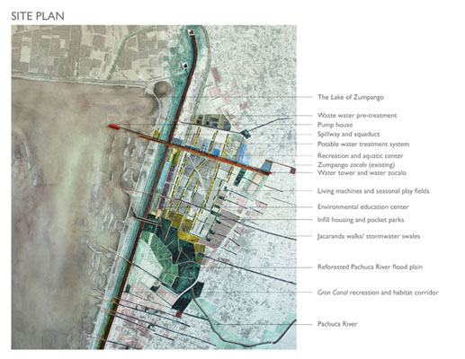
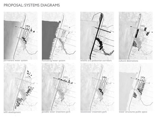
PROJECT ELEMENTS:
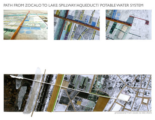
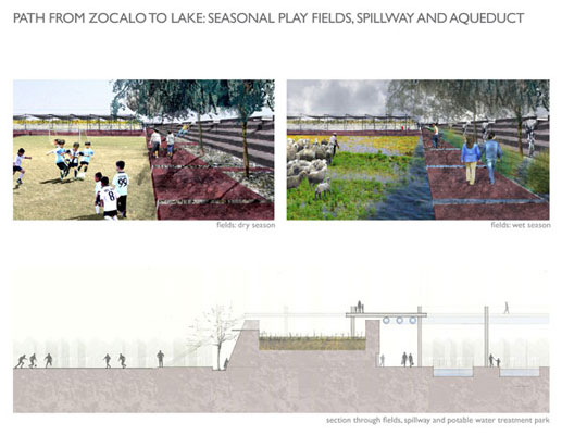
A spillway draws floodwater from the lake
toward the town, allowing it to safely flood seasonal
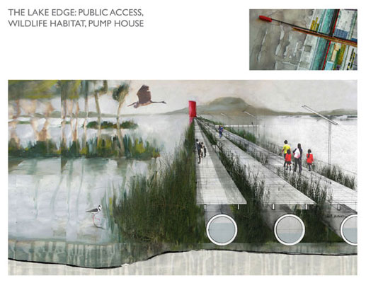
play fields and irrigate crops. A public processional
from the town zocalo to a pump house in the
lake celebrates the sequence of water treatment that
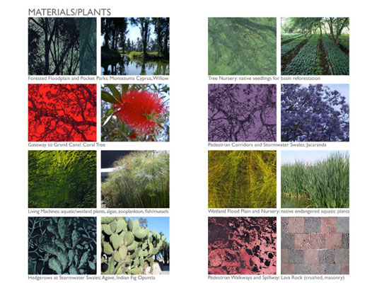
transforms lake water into potable water supply. Living
machines and wetland systems treat 32 mg/d of wastewater,
while also forming an armature for recreation and agricultural
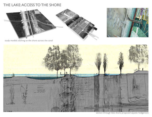
fields. Aquatic hedgerows make a more ecologically complex
shoreline for the lake, while, on the city side, pocket
parks create thresholds between existing neighborhoods,
new infill housing, and the park. Jacaranda hedgerows
mark lateral pathways for stormwater and pedestrian
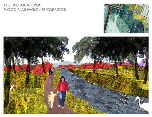
access across the canal to the lake. The Pachuca River
gains a wide, dense floodplain corridor.
THE SITE: ASSETS AND OPPORTUNITIES:
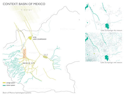
Basin of Mexico: A landscape of
duality: The landscape identity of this arid
place is inseparable from its oscillation between dual
characters. It is half a parched place with subtle traces
of seasonal wetness, waiting for the rain. In this dry
season, the rain comes suddenly, sweeping through the
valley in powerful storms. During these months green
colors become latent, leaving muted shades of sand.
Month by month the rains return. Wetness becomes dependable,
a daily event, leaving behind watercourses and pools,
rendering the soil softer, allowing crops to grow. The
city’s hydraulic endeavors over the course of
its history have addressed this dual character as a
dangerous problem, using huge infrastructural feats
to fight its threatening floods and droughts. In this
proposal, we recognize this dramatic flux as critical
to the Basin's health and identity. The lake, reformed
as a cultural, ecological system, will reconnect inhabitants
to the cycles of water upon which they depend.
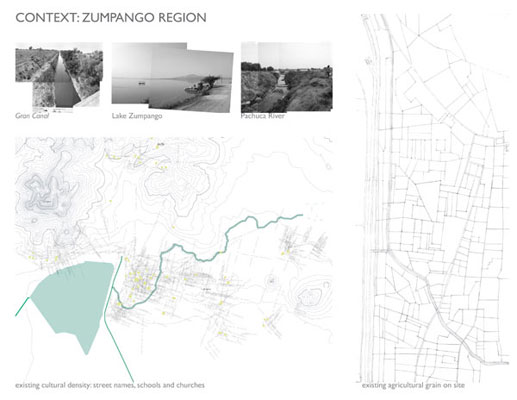
The Town: Historic City / Fouled Reputation: The town of Zumpango has a vibrant, historic center, yet it has lost nearly all connection to the lake that spurred its original settlement and offered it a name. In the Federal District of Mexico City, many residents know little of its active zocalo and expansive lake, associating it instead with the course of the sewage-laden Gran Canal.
The Lake: Remnant / Tank: Lake Zumpango links the area to the Basin of Mexico’s unique history, as it is one of the last three remnant lakes of the once powerful lacustrine system. The lake has been named a “Water Sanctuary” by the government, but steps have not been taken to define or investigate this status. Rather, the lake is better known for its role as a massive piece of infrastructure, a flood-control “tank.” While the lake provides a habitat for diverse flocks of migrating birds, its impenetrable edges raise questions of access, visibility, and missed opportunities. And yet the people find ways to overcome these barriers, to precariously occupy the lake and its edges.
The Gran Canal: Barrier to the Lake / Connection to the Basin: Multiple linear barriers currently separate the town from the lake. The Gran Canal is the key culprit. The canal, a ten-meter deep ravine, was heralded on the day of its opening as Mexico City’s savior, emptying waste and floodwaters from the basin. The deep channel carries the sewage of Mexico City north through Zumpango, running parallel to the eastern edge of the lake, defining an extreme, un-crossable boundary. The blackwater is dropped into two grand “water boxes” at the northeast corner of the lake, which direct the effluent to the agricultural fields of Hidalgo, the food source of the region. We see the canal as another missed opportunity, a monument in its own right, connecting the city, if now negatively, to the water system of the entire basin.
The Pachuca River: Eroded Arroyo / Potential Corridor: The Pachuca River emerges at the summit of Mt. Pachuca and runs its course through the agricultural fields east of Zumpango. The seasonal watercourse has been described as the sewer line of the lands that flank its eroded banks. When it reaches Zumpango it is channeled in a concrete bed, dismissed from the life of the city and released into the fissure of the canal.
DESIGN INTENTIONS:
- Connect the new and proposed city to the lake edge.
- Celebrate the flood control function of the lake, creating public engagement with both the infrastructural role and the seasonal fluctuations of the local water system. Direct floodwaters to support irrigation for intensive productivity.
- Use public space as a way to connect the existing city of Zumpango and its residents with their neighbors arriving to the new urban corridor.
- Increase the complexity of the lake edge to create diverse wildlife and human habitats.
- Provide opportunities for citizen connection to wastewater treatment processes within an experiential, productive, shared landscape.
- Provide collective recreational opportunities to reinforce the identity of the city, both existing and new.
- Increase the lake’s local and regional significance by creating a destination along its shores.
- Strengthen the ecology of the lake as aquatic habitat, the Pachuca and the Gran Canal as wildlife corridors.
- Use an armature of hedgerows to channel, cleanse and infiltrate stormwater while also creating access routes between local neighborhoods, the park and the lake.
- Provide economic opportunities for production based on the resources of water, and tourism.
- Integrate facilities for public use: schools, environmental education centers.
Provide potable water to the city, making its processes of treatment visible with a procession from the center of Zumpango to the lake.
|