PROJECT STATEMENT: New Orleans has suffered the slow loss of maritime activity due to port consolidation and rapid, comprehensive loss of civic stability due to Hurricane Katrina. Paradoxically, the hurricane heightened public understanding that the riverfront is in fact the “high” ground and ripe for possible redevelopment. The landscape architects were equal collaborators with a core design team hired by the New Orleans Building Corporation to reposition the riverfront as a singular, continuous ensemble of international prominence.
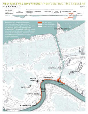
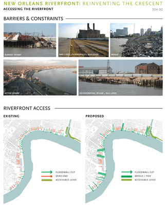
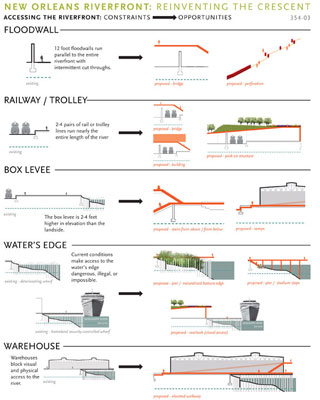
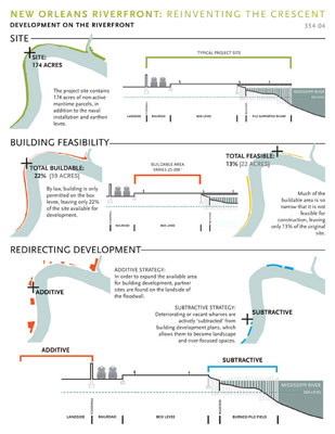
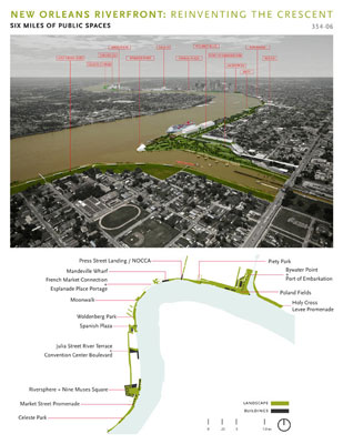
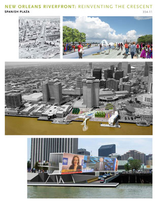
PROJECT NARRATIVE: The sinuous, east bank riverfront encompasses a full range of riverfront typologies: from vacant, derelict and burned wharves to Homeland Security-restricted cruise ship terminals and shipping warehouses; ageing ferry terminals and a sprawling US Naval logistics facility; all punctuated by a festival marketplace and the Audubon Aquarium. Canal Street, the main vehicular corridor, arrives at an overly congested Spanish Plaza, and the French Quarter skirts the riverfront, but actually getting to the river is made difficult by massive floodwalls, street car and heavy rail tracks, and the levee itself. These same critical infrastructure components shape highly restrictive building envelopes, and render the majority of the riverfront un-developable with few notable exceptions. The once sprawling Port of New Orleans has consolidated into a smaller and more secure footprint, rendering numerous wharves and warehouses as vacant surplus. The city and the port signed a cooperative agreement to coordinate redevelopment of 174 acres of non-active maritime parcels for public use. Through assessment of governing regulations and technical limitations, both federal and local, the build-able area decreases to 39 acres, with an even smaller footprint of 22 acres available for practical construction. In effect, the redevelopment strategy quickly becomes a series of discontinuous nodes distributed along a six mile length of riverfront. The concept approach quickly shifted from a building redevelopment plan to a 152 acre riverfront landscape plan.
Reinventing the Crescent was sparked by Hurricane Katrina and an unparalleled opportunity to reevaluate the languishing waterfront and to supplement New Orleans’ unique character, unusual street grid, and historic architecture with visionary yet practical and sustainable design. In the post-Katrina era, the Mississippi and its banks must serve new, equally crucial purposes. As the city continues to evolve, there is an evident need for a strategic entrepreneurial outlook. The development of new economies and new neighborhoods will influence cherished and established neighborhoods. This new development has the charge to not only reinvent the riverfront, but reconnect the existing neighborhoods to the river through a diverse public landscape imbued with additional cultural destinations.
Administration
The New Orleans Building Corporation (NOBC) is a public benefit corporation established by the city council to spur economic and cultural redevelopment of vacant or underutilized city properties. The NOBC is the point corporation for the city to hire consultants and fund construction projects along the riverfront. Parallel city efforts to revise the zoning code and neighborhood-focused planning processes have occurred and continue.
Goals & Objectives
Four goals address altering the status quo relationship of New Orleans to the Mississippi River: that of maritime infrastructure effectively restricting connection between the two.
1. Negotiate the physical barriers to public access at the Mississippi River
2. Create continuous linear access and a network of great green spaces along water’s edge
3. Create gathering places and moments of distinct character encouraging civic activity and foster community energy
4. Build new architectural icons or landmarks that offer an authentic 21st Century design face for New Orleans
Five additional goals address economic and civic goals geared toward recovery and long term prosperity.
5. Encourage beautiful, sustainable places to live near river’s edge
6. Increase municipal revenue by $40 million annually by expanding the property tax base
7. Stimulate economic growth by providing proper infrastructure
8. Create approximately 4,500 new, permanent jobs and thousands more temporary construction jobs
9. Trigger $3 billion in new private investment near the riverfront
The nine goals are an “IF-Then” proposition: IF the riverfront plan is implemented, Then economic growth will be realized.
Environmental
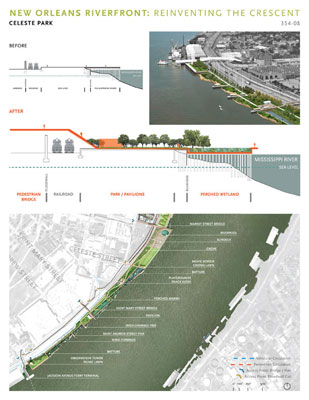
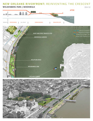
The concept emphasizes consolidation of mixed use development along existing and expanding street car lines. Architectural strategies focused on cooling and water conservation according to LEED, while assuming expansive green roofs to counter the massive existing convention center roof. With so much of the riverfront infrastructure derelict and unsafe, we recognize that the entire budget could be spent removing existing components with no funding left for a landscape budget. To counter this, we propose to leave a majority of the deteriorating wharves in place, particularly where fires have ravaged their wood decking and piles. The concept anticipates a suspension of Corps dredging adjacent to these structures which will accelerate the accumulation of sedimentation and growth of volunteer vegetation along the batture (river sedimentation and volunteer vegetation), incrementally transforming the riverfront from fully armored to partially vegetated. Tulane University/Xavier Center for Bioenvironmental Research is a steering committee member, working with the design team to locate their research-focused RiverSphere institute on the riverfront, complemented with a public landscape of demonstration wetlands and gardens in addition to alternative energy river turbines.
Analysis
The design team compiled maps and aerials, utilizing recent Katrina data and documentation, viewed the entire length by boat to better understand the water edge, and walked the site repeatedly for first hand technical assessment of the existing structure for demolition, rehabilitation or adaptive reuse. We incorporated initiatives from the UNOP planning process, the City’s Riverfront Vision 2004 and other preceding studies. We diagrammatically tested various strategies for development and landscape, and digitally inserted proposals into photographs for public presentation, demonstrating before and after scenarios.
Design Process
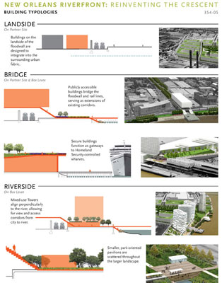
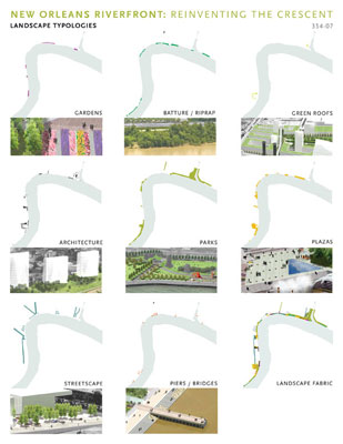
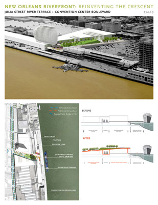
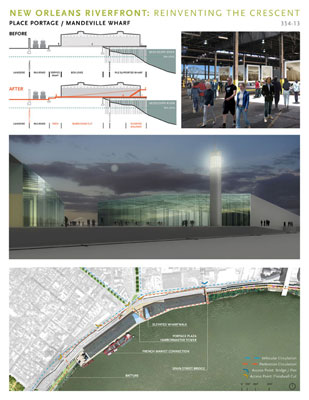
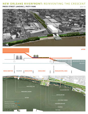
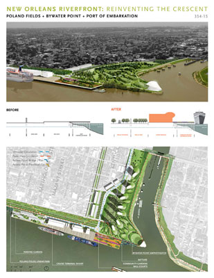
The Reinventing the Crescent proposes a radical transformation—converting six miles of Riverfront from a concrete zone of physical and visual barriers to an accessible and green public landscape. As a single entity, the new riverfront will connect the city of New Orleans to the Mississippi River at an unprecedented scale. This new public landscape knits the fabric of the city to the river’s edge, along a continuous corridor. A diversity of proposed landscapes will coexist, with public parks anchoring opposite ends of the project, while smaller, neighborhood-oriented parks are periodically inserted along the project’s length. These parks contain a range of destinations including wetlands, terraces, amphitheaters, sport courts and cafes. Urban plazas are strategically located at intersections of major perpendicular corridors connecting deep into the city, to celebrate the city’s cultural history while also creating energetic new spaces adjacent to new development. Native batture will be expanded to create naturalized edges where wharves have been or will be removed. The wild appearance of the batture is often juxtaposed against more formal gardens lining the continuous river walk at higher ground. Sustainable streetscapes and paths provide efficient circulation and also shaded, green corridors passing through the city. Finally, a series of pedestrian piers and bridges will carry people over floodwalls and train tracks and ultimately to view out across the expansive Mississippi River itself.
Implementation
On 9 January 2008, the NOBC Board, including Mayor Ray Nagin and members of the City Council, endorsed the plan. They also authorized $127 million in funding for phase one, allocated to jump start design work and construction primarily of landscape components. Phases two and three are targeted to conclude by 2018, to coincide with the 300th anniversary of New Orleans, with a total public cost of $294 million. The initial public investment in phase one constitutes the “IF” expenditure, demonstrating a public commitment to improve the riverfront. This will be followed by a “THEN” expenditure of private investment responding to the governmental investment, leading to sustained revenue generating activities for the riverfront, anticipated as a mix of commercial, residential, educational, and cultural. A third stage will follow public and private investment responding to and building upon the two preceding growth investments.
Economics
The State of Louisiana is anticipated to shoulder 55% of the cost, with local government funding 16%. The Federal government would finance 23% through research and levee-related activities, with the remaining 6% assigned to private and non-profit investment. Private investment alone is expected to approach $3.5 billion through 2024, annually reducing governmental debt through new jobs and taxes, entices visitors to extend their stay in New Orleans. If just 8% of pre-Katrina visitors added one additional night to their stay, nearly $500 million in direct spending is generated.
Reinventing the Crescent is far more comprehensive and ambitious than merely improving the existing tourist facilities. The most impressive feature of Reinventing the Crescent is far less easy to quantify but will likely have the most profound effect on the future of the city. The aesthetic improvements and increased quality of life around this development will invigorate an essential area of the city – the neighborhoods adjacent to the proposed project account for over 50% of New Orleans employment, and 40% of the business units while generating over 60% of the payroll throughout the city. Improving the attractiveness and appeal of the riverfront is essential to attracting new citizens and economies as well as keeping the residents interested in making New Orleans and Louisiana a better place to live. Even if the projected private investment is never realized, as unlikely as that actually is, this is a prudent, acceptable, and essential public investment.
Options
The design team generated four diagrammatic conceptual approaches. The Existing approach left the majority of existing components in place and adjusted them only slightly to improve public access. The Subtractive approach removed essentially any wharf or structure that was derelict or had been damaged by Katrina or the aftermath, allowing for maximum reversion to an un-maintained, ‘wild,’ batture landscape. The Additive approach envisioned a dramatic improvement of parcels with accentuated development opportunities by including contiguous ‘partner’ parcels outside the study area. The Hybrid approach constituted a blend of each of the preceding approaches where parcels were assessed individually in terms of condition and proximity to residential neighborhood populations. Ultimately, the Hybrid approach evolved into the final concept where a lengthy stretch of derelict wharves were selectively deconstructed for expanded batture, while at the other end of the spectrum, a soon-to-close Naval installation outside the study boundary was identified for multiple tower residential development. The development potential, physical constraints and regulatory restrictions on each individual parcel made a uniform strategy unworkable. The result is a diverse concept genuinely rooted in the context of the individual neighborhoods, whether purely industrial, densely residential, or tourist dependent.
Public Process
The six month project included a monthly public presentation during which assumptions, programming, and evolving concepts were presented for public comment. Constructive criticism and concerns were registered, with each Powerpoint presentation posted to the NOBC website for distribution and study. Additional smaller scale neighborhood meetings were held with particular groups to openly discuss desires and compatibility issues with regard to adjacent historic neighborhoods. The New Orleans-based Audubon Institute and the local chapter of the Trust for Public Lands participated in the formulation of the concept through the steering committee, pledging their non-profit financial resources to realize components of the plan.
Summary
Reinventing the Crescent has served to refocus attention on the long ignored New Orleans riverfront, recalibrating individual planning efforts to think about the riverfront as a unifying component of recovery. The thrust of the design concept and supporting economics is that for the cherished historic New Orleans neighborhoods to survive with a reduced population and declining industry, new development and new public landscape will be a key component to attract and retain visitors and residents alike. Reinventing the Crescent questioned the technical restrictions assigned to flood control structures, rail lines, and wharves, integrating each into a public landscape rich in composition, programming and character, embracing both the uniquely historic and forward-looking creative culture of New Orleans.
 |
|
PROJECT RESOURCES |
|
|
Landscape Architecture:
Hargreaves Associates
Architecture:
TEN Arquitectos
Urban Design Coordination:
Chan Krieger Sieniewicz
Architect / Project Management:
Eskew+Dumez+Ripple
Documentation of Existing Conditions:
St. Martin Brown Associates
Cultural Strategies:
Carole BeBelle / Ashe Cultural Center
|
|
|
|
Civil Engineering & Utilities: Infrastructure
Kulkarni Consultants
Maritime Infrastructure & Transportation Interface:
Moffat & Nichol
Regulatory Mapping:
Julie Brown AIA
Community Outreach:
Robinson Et al.
Economics:
James Richardson
|
|
|
 |
|