Project Statement:
The project exposes the essence of The
Sea of Galilee area that is made up of layers of reality,
history, and myth, presenting the space as a multicultural
landscape and creating a new place for tourism, which
relates to its environment, from both the aspect of
its physical existence and its existence in people's
consciousness.
Project Narrative:
Project motivation and approach
The project creates a new space for tourism on the Sea
of Galilee coast, which refers to its environment, from
the aspect of both its physical existence as well as
its existence in people’s consciousness. It is
in this way that the project strives to create a dialogue
between the environment and the water line.
The Sea of Galilee area constitutes a
focal point attracting numerous visitors and tourists
from Israel and abroad. This is Israel's only lake and
its major source of water, as well as constituting an
area of great importance in Jewish tradition and one
of the most important holy places in Christian tradition.
The Sea of Galilee and its environs are located in an
open natural landscape, barely changed since the Roman
era.
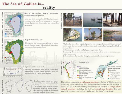
Currently, most of the formally arranged
locations for leisure and recreation activities are
concentrated along the water, which overloads the shoreline
and does not allow the general public to enjoy the wide
range of landscape and cultural assets in the area.
The dynamics of the changing water level
in the Sea of Galilee, as result of an amount of rains
and the pumping, also affect the look of the shoreline
and our attitude toward it. The expected difference
between the highest and lowest water level is six meters.
The significance of the changes in the water line on
the shore is expressed in the shifting shoreline, which
may be 60-100 meters on the steep shores, and 500-800
meters on shallow shores.
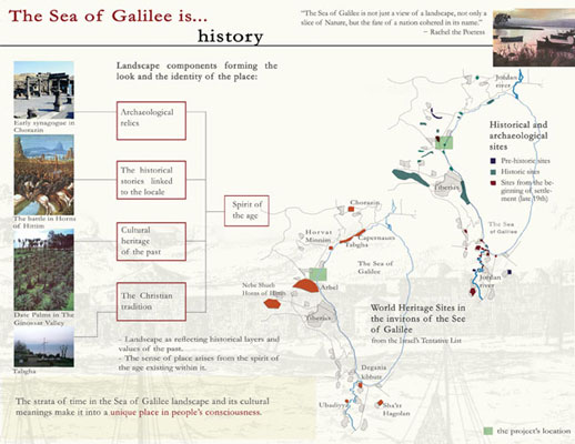
The many archaeological relics in the
area, the historical stories linked to the locale and
the cultural heritage of the past are an inseparable
part of the landscape and significant components in
creating its identity. The essence of The Sea of Galilee
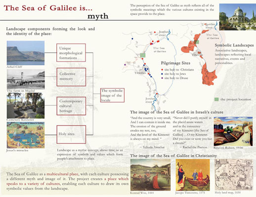
area is made up of three layers: reality, history and
myth, the last of which embodies all of the symbolic
meanings of the Sea of Galilee environs. This is why
the project's major idea is the exposure of the history
and myth layers along with the reality layer for the
presentation of the space as a multicultural place.
The area contains pilgrimage sites holy to Jews, Christians
and Druze. The image of the Sea of Galilee changes from
person to person and from culture to culture, therefore,
the project creates a place which speaks to a variety
of cultures, enabling each culture to draw its own symbolic
values from the landscape.
The project proposes a new planning approach
to the Sea of Galilee region, an approach which will
preserve and emphasize the existing landscape values,
so that the space around the Sea of Galilee will be
perceived and will function as a single whole cultural
landscape (including the Sea) and not only as a shoreline.
This will lessen the pressure on the shores and enrich
the visitor's experience.
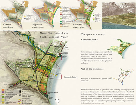
The Project focuses on the Ginossar Valley
area on the northwest shore of the Sea of Galilee, with
the following goals:
— Creation of a new space for
tourism, which refers to its environment, from the
aspect of both its physical existence and its existence
in people’s consciousness, and not only to the
water line.
— Linking the different sites, landscapes, narratives,
and traditions about the area to present them as a
single cultural landscape unit to create a new tourism
experience which is much broader than is currently
perceived and not limited only to the shore.
— Since water level variability
is part of the Sea of Galilee's uniqueness, this project
exposes a wide range of characteristics of the different
levels, and uses this to create a range of opportunities
for tourism development.
Environmental, cultural and historical
data and analysis methods
Because the project exists simultaneously
in reality and in the national and religious consciousness,
I have examined the space simultaneously from its physical
and cognitive aspects. The cognitive space is composed
of the visitors’ symbols and images reflecting
their perception of the Sea of Galilee. Through questionnaires
and interviews with tourists and visitors, I examined
the image of the Sea of Galilee in people’s consciousness,
the images generated by the Sea, and which space is
perceived as the Sea of Galilee. Pilgrim maps of the
Holy Land, representations of the Sea of Galilee in
Israeli and Christian cultural sources, paintings of
New Testament scenes, and other items, were examined.
The cognitive maps that Israelis were asked to draw
show that they recognize only a very narrow section
of the area surrounding the Sea of Galilee. On all of
the maps, the most outstanding element is the road around
the Sea of Galilee, quite close to the shoreline, which
cuts the Sea off from its physical and perceptual environs.
Other material collected include physical
data, proposed recreation spots and their location,
studying the character of the tourism in the area, and
extensive information about the local history and narratives
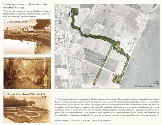
associated with the place. Important historical information
included old aerial photographs, old photographs of
settlements, orchards and natural landscapes which assisted
in the identification of landscape elements that have
been preserved, and which hint at its historical heritage.
Maps of the conflicts between development schemes and
landscape values demonstrate that the western Sea of
Galilee area is under a greater threat than its eastern
side. In addition, maps of the disturbed areas show
that the western side is much more affected by human
activity than the eastern side, which still maintains
a continuum of open, natural areas.
It is important to note that the southern
section of the Ginossar Valley is the only section in
the Sea of Galilee environs defined on regional and
local level planning schemes as designated for guesthouses,
and many development schemes are already applicable
to this section. These plans are likely to block off
public access to the water, and the construction that
may cover the entire shoreline area is likely to damage
the unique identity of the Ginossar Valley.
Site selection
After an analysis of the processes of
the Sea of Galilee environs, and understanding its elements,
the project focuses on the Ginossar Valley area northwest
of the Sea. This is agricultural land, currently standing
up to the pressures of heavy tourist development. In
addition, it contains cultural and landscape values
of the highest importance for preservation in order
to preserve the identity of the locale. The Ginossar
Valley has a variety of cultural meanings which reflect
various traditions. In addition to its important role
in the history of Israel, the Valley has a very high
pilgrimage value, as most of the stories of the miracles
and travels of Jesus are associated with this area.
The selected site challenged me to find
a proper balance between preservation and development
as well as the opportunity to create an emotional tie
between people and locale through integrating culture-religious-nature-landscape
into one creative work.
Planning strategy
The understanding that it is impossible
to keep pursuing the water level and base the development
of lodging and recreation facilities on the water line
only, along with the need to bridge the gap between
the image of the Sea of Galilee and the actual place,
led me to conclude that the project should expand the
area designated for tourism and recreation without limiting
it primarily to the shore area, as is the current situation.
The project encourages development of a wide range of
lodging and recreation facilities based on the wide
variety of landscape and historical assets existing
in the environs of the Sea of Galilee.
Based on all of the conclusions arising
from the analysis, I proposed two development alternatives
for the entire western side of the Sea of Galilee, in
which the Ginossar Valley is located. Planning the chosen
section would be a direct result of a holistic look
at the entire region. The alternative of theme spaces
emphasizes the cultural identity of the various spaces
through exposure of the existing cultural and religious
values connected to the site. This option is based on
the creation of very close ties between the sites belonging
to the same theme space so that it is perceived in people's
consciousness as an entire entity and as place. The
second option, in contrast, emphasizes the linear spaces
perpendicular to the Sea of Galilee, which embody a
range of natural and landscape values. These spaces
will function as recreation attractions to people from
various cultures, and will act as the pathway for activity
or an attractive hike connecting the guesthouses located
in the rear and the Sea.
Based on the two options, I proposed a
Master Plan for the northwest Sea of Galilee area in
the center of which lies the Ginossar Valley. The plan
emphasizes the tourism development in the rear strip
and reinforces the tie between the rear space and the
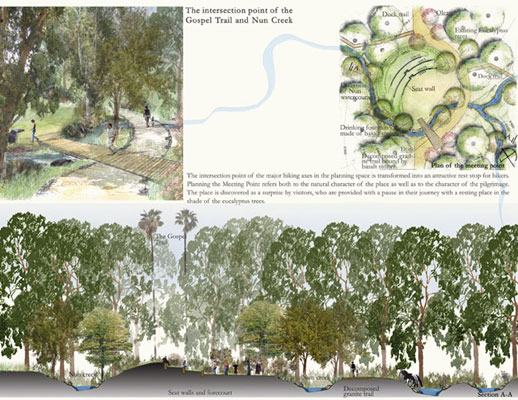
coastline. In like manner, the design proposes the “Gospel
Trail” to link the spaces, interlacing values
of culture, religion, nature and landscape all along
its length.
In future planning schemes, the entire
Migdal coastline area is designated for hotels in such
a way as to disperse the construction in an almost uniform
way across the entire area. Economic activities are
indeed likely to conserve the agricultural landscape,
and therefore, the project proposes a development scheme
which integrates tourism development within the currently
existing agricultural space by building in concentrated
areas and leaving more extensive open spaces. In addition,
integration of a variety of open spaces in the new fabric
will attract vacationers.
Project design
The current project attempts to reinforce
the sense of place arising from the tension between
myth and reality through the creation of a dialogue
between the landscape components that hint at the myth
and the past of the Sea of Galilee and the new fabric.
The design of the space as a weave of landscapes, historical
and recreation sites integrated with various traffic
axes within the space, each emphasizing a different
asset of the Sea of Galilee - these are the tools creating
an experience of place.
In addition to the agricultural landscape
with its fruit gardens, three components of the landscape
hinting at the heritage of the past and which provided
the foundation for the project design are the Nun Spring,
used to irrigate the Valley in the past; the alle` of
Washingtonia palms dating from the 1920s; and the Villa
Melchett and its historical garden. These are the components
that are building the locale’s identity, therefore,
serving as anchors in the spatial planning, and receiving
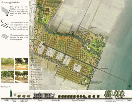
a renewed function. Thus also the spring and Villa Melchett
constitute two points of interest between which the
new fabric is built. The pedestrian link between the
rear space and the coastline takes place along the axis
of the Nun Creek. The project proposes to raise the
highway crossing the Valley to enable continuity of
the fabric and access to the shoreline on the natural
axis. The additional design principles are the reinforcement
of the axes perpendicular to the water line and emphasizing
them in a different way, and the designing of the areas
between the axes as the connecting fabric.
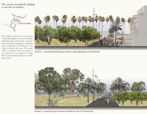
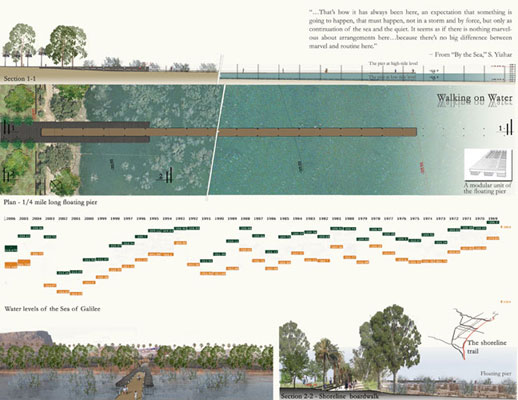
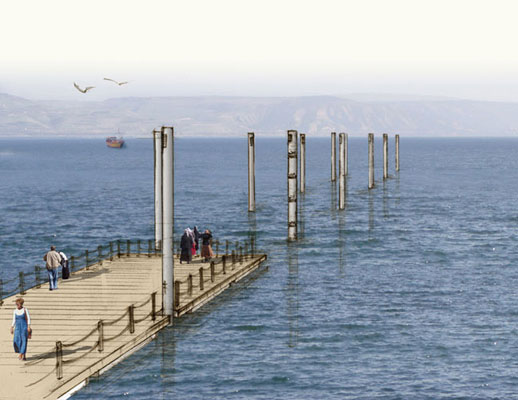
The floating pier beginning at the maximum
water level (-208.9m.) and ending at the minimum water
level (-215.00m.) illustrates the dramatic nature of
the change in water level. Together with the shoreline
boardwalk, it constitutes a kind of monument to those
water levels, which have become an Israeli national
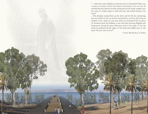
myth. In the Christian narrative, it was here that Jesus
walked on water in the area between Magdala and Capernaum.
The walking onto the floating pier is a simile for walking
on water, and is likely to be a near-mystical experience
for pilgrims visiting Israel on a tour in the footsteps
of Jesus.
Implementation
Because the Sea of Galilee region cuts
across the areas of several different local and regional
councils, each of which wishes to handle the territory
within its own jurisdiction, there is a need to assimilate
holistic analysis and approach methods on the level
of an overall national outline scheme for the coastline.
The Migdal Municipality Local Council and private developers
are most likely to be interested in specific planning
for the coastline, based on an understanding of the
economic advantage that such a project would generate.
The Migdal region is only one example
of implementation of the planning approach to the Sea
of Galilee coast. Regional planning will create an outline
of development areas to the rear of the water line and
the unique points for the designer’s intervention,
which will work together to create a unique space for
tourism integrating culture, religion, nature and landscape.
|