Project Statement
Charleston Waterfront Park established an important precedent
for preserving the water’s edge for public use
by all through partnership between local leadership
and a landscape architect, who gives form to civic aspirations.
The innovative design integrates significant sustainable
and urban design ideas with the landscape architecture.
The park remains a catalyst for investment in the city,
creating far more value than private development. The
park is a beloved symbol of the city’s transformation.
Project Narrative
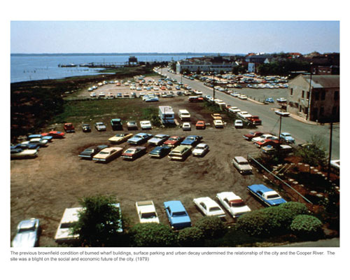
As is the case in many cities, Charleston’s
waterfront, the Cooper River, suffered from an industrial
history of use followed by abandonment.
Charleston’s older port facilities became obsolete
and the upland activities migrated away. The marshland
that existed before industry intervened was ruined.
The original surrounding environment
of adjacent neighborhoods, which had grown up around
the early port economy, are among the most historic
in the city. By the early 1980’s these areas were
languishing, however, and the waterfront itself had
been given over to surface parking.
The original intent was
to establish the waterfront as a public space and to
stimulate economic growth to turn around the declining
neighborhood and launch a larger city regeneration.
Before any work could begin on the waterfront, sites
for new parking structures were identified and built
to accommodate necessary parking displaced from the
waterfront. Conceiving of the site as both a neighborhood
park and a public park, Mayor Riley lead the design
team on a day long tour of Charleston so that the team
could understand the flavor of the neighborhood and
city at large. The local materials, design, culture,
and way of life influenced every decision.
“The park constitutes
a major civic contribution, that its popularity
with all segments of the city has exceeded expectations
and that, altogether, ‘it is an extraordinary
piece of work’.”
- The Waterfront Center Awards Jury, 1992
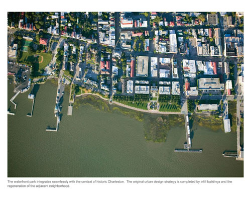
The graceful parkland along
Charleston’s Cooper River visible today belies
the fundamental design challenges of
this important transformation. The site lies on former
marshland with unstable soils; hurricanes batter this
side of the peninsula; the elevation of the site was
considerably below the flood level; derelict piles and
contaminated soils created polluted and unattractive
waters; surface parking was the dominant use; blocks
of Condor Street would have to be removed to truly reconnect
the people to the waterfront; and surrounding neighborhoods
and the downtown were in heavy decline.
Because new paving and other
site structures would settle on the unstable marsh soils,
the design team crafted a strategy to preload the soils
and wick out water. This multi-year process required
patience but ensured that the available funding was
sufficient to carry out the park improvements. High
winds and tides needed to be considered in the design
and layout of all park elements from the bulkhead to
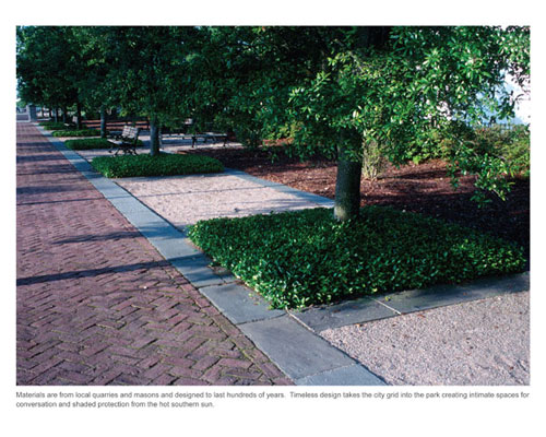
the furnishings. Project construction and materials
were designed to last hundreds of years.
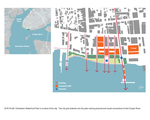
Reconnecting the city and
people to the waterfront required connecting the human
systems of the city and the natural systems of the waterfront.
This greatly changed the original surrounding
environment of the neighborhood. The city grid
extends into the park making physical and visual connections
to the Cooper River. This framework creates site lines
for landmarks and active areas at the termini of primary
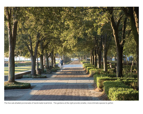
streets. Shaded by tree canopy, quiet garden rooms of
varied design connect to the city edge became extensions
of the urban form.
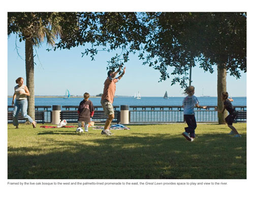
The shaded urban park opens up to the gracious lawn
overlooking the river and the formality of the city
grid gives way to a more organic organization of space
based on the water’s edge. The large public lawn
frames the center fountain which brings water into the
park strengthening the visual land water connection.
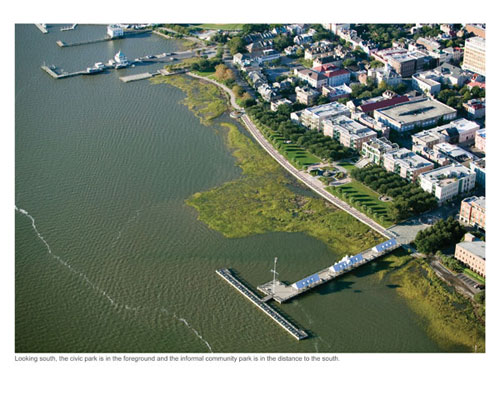
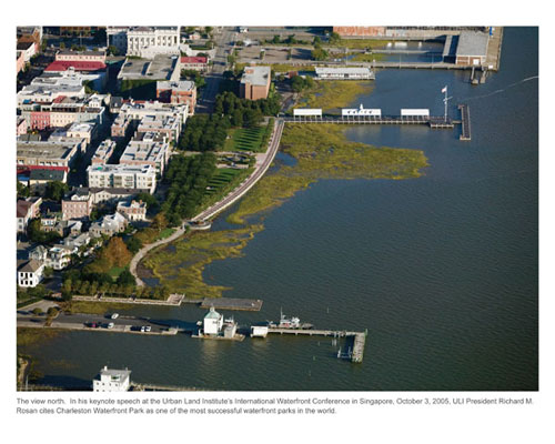
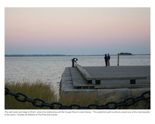
The 1,200 foot palmetto lined esplanade follows the
natural water line ensuring public access to the water’s
edge. Restored salt marshes sweep out into the river
from the esplanade edge, creating valuable habitat and
a rich visual experience, while keeping the memory of
the former port with the pattern of pilings and inevitable
deposition at the mouth of the river.
The aspiration to improve
the community context based on Charleston’s
southern heritage and future rebirth was deeply shared
by the mayor, community, and the design firm. Reaching
out to the community which consists of old and young,
black and white, wealthy and poor, was very important
for success.
Exemplified by the hiring
the local traditional iron worker Philip Simons to create
artwork for the park gateway, project goals included
integrating Charleston’s past and future, reaching
out to all groups represented in the community, such
as African Americans and the elderly, and stimulating
the local economy.
“It is now a glorious
part of the public realm and it is enjoyed by local
and regional residents and tourists. It is a very democratic
place, as it should be.” - Joseph P. Riley, Jr.,
Mayor of Charleston, South Carolina
Social
concerns were a major driving force in the design of
the park. Great care was taken to create a true public
space for everyone, not a few. Instead of the originally
proposed yacht tie up, the head of the new 365-foot
pier was designed for recreational fishing, thereby
making it available to everyone regardless of wealth.
The long pier also allows people to experience the deep
water beyond the salt marsh. Lighting was kept to a
minimum so that in the evening the stars would be easily
seen. Also of great concern was the environment. The
Charleston Waterfront Park needed to be sustainable
in every way, environmentally, economically, and socially.
At every level, the park design demonstrates sensitivity
to the environment. Sustainable solutions extend from
the engineering ideas to economic development to the
restoration of salt marsh that offer habitat, cleanse
pollutants, and buffer the land from the force of coastal
storms. Committed to preserving and enhancing the salt
marsh habitat that was gradually reclaiming the derelict
port with its accumulated silts, the area has been mitigated
and a robust river habitat now flourishes. This unique
estuarine environment reveals the area’s marine
ecology and wildlife while serving as a stunning element
that unifies the entire park.
Since
the park opened, property values in the neighborhood
have risen and tourism is up. Many successful renovation
and infill projects now line the blocks near the park,
as outlined in the design firm's urban plan that preceded
the waterfront design. It is considered a favorite amenity
by residents and a must see by tourists.
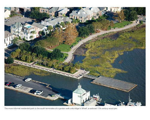
With real concern for sustainability and preservation,
the 17th century Adger’s Wharf pier was restored
and was rebuilt in the original footprint with the original
granite which was fished out of the river and reused.
The pier was reconstructed using log cribbing construction
of native palmetto trees to last for many generations.
Charleston
Waterfront Park has had tremendous impact on the public
realm, influencing and shaping the civic realm of American
cities and elevating the role of landscape architecture.
Although Charleston is a relatively small city, the
Mayor’s philosophy of civic beauty and his pride
in Charleston Waterfront Park has carried the message
across the country over the course of this generation.
Both Mayor Riley and the design firm have received multiple
national awards for the waterfront and its local and
national impact. Charleston Waterfront Park is still
cited among the worlds great innovative waterfront successes.
Significantly
impacting the profession and practice of landscape architecture,
the park was a breakthrough on many fronts, setting
the standard for design values that are taken for granted
today. The design of the park is indicative of thoughtful
research into a community and culture to create a park
that resonates with local residents and endures over
time as an authentic experience. The success of the
park rests on the engaged leadership of the local constituency
that can express aspirations and the landscape architect
who can express these aspirations in design through
form, materials and sustainability.
The
park is successful in demonstrating the role of open
space in urban regeneration. Rather than exploit the
value of the 13 acres for private development, the park
has played an important role in improving the economic
status of the downtown as a whole and the entire district
surrounding the park.
Charleston
Waterfront Park has become a beloved destination for
people of all ages. The design has stood the test of
time, as the park’s popularity continues unabated.
SELECTED AWARDS
FOR CHARLESTON WATERFRONT PARK - ASLA, Honor
Award, 1999 | Presidential Design Awards, Federal Design
Achievement Award, 1991 | BSLA, Design Award, 1991 |
The Waterfront Center, Top Honor Award, “Excellence
on the Waterfront” Awards, 1992 | The Waterfront
Center, Honor Award, “Excellence on the Waterfront”
Awards, 1990 | American Association of Nurserymen, National
Landscape Award, 1993
 |
|
Project
Resources |
|
|
Master Planning, Urban Design, Landscape Architecture,
Civil Engineering:
Sasaki Associates, Inc.
Local Landscape Architect:
Edward Pinckney Associates, Ltd.
Electrical Engineers:
Holladay, Coleman & Associates
Structural Engineer:
David Carsen
|
|
|
|
Geotechnical
Engineers:
LAW & Associates, Inc.
Contractor:
Ruscon Construction Company, Inc |
|
|
 |
|