Project Statement
Penn Connects – A Vision for the
Future, outlines the growth of the University of Pennsylvania
and represents a strategic use of contemporary planning,
urban and landscape design. It provides a model for
integrating campus and the surrounding urban fabric
to create a visionary framework for public realm improvements
and campus expansion. The outcome is a dynamic mixed-use
urban district that reclaims industrial sites and replaces
transportation related tracts along the Schuylkill River
corridor to a vibrant gateway between Center City and
University City.
Narrative Summary:
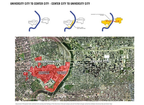
In April 2007, the University of Pennsylvania will acquire
24 acres of land along the Schuylkill River in West
Philadelphia--land which currently separates the Penn
campus from the river and from Center City Philadelphia.
Generations of Philadelphians have thought of this district
as the literal gateway to the city and the universities.
At present the area consists of a vast working infrastructure—a
bustling neo-classical railway station, elevated rail
lines rising 60 feet on massive steel and stone supports,
numerous bridges carrying both vehicles and pedestrians
and connecting to highways on both sides, a vast postal
processing facility, and about 14 acres of surface parking.
Activity takes place not just at all hours but at multiple
levels – trains passing above, cars speeding by,
and the odd boat plying the river.
The land acquisition, including
other University-owned parcels located along the Schuylkill
River, will provide over 42 acres of land for future
development in what is known as the east campus area.
It will enable Penn, for the first time in its history,
to reclaim and design a brownfield into a new gateway
to the campus from Center City, to establish a physical
presence along the Schuylkill River, and to establish
new connections with the surrounding urban context.
The area acquired presents several design challenges
including: major transportation corridors that segment
and define the boundaries of the land area; irregular
and fragmented development parcels; land parcels which
are inaccessible from the existing road network; elevation
differences in the road network, including bridges over
the Schuylkill River; the 100-year floodplain of the
river; and incorporation of the iconic stadium and sports
arena, Franklin Field and the Palestra, in a sensitive
and appropriate manner.
In anticipation of the acquisition,
the University engaged in a year long planning process
to develop a vision for integrating the acquired land
into the campus environment. The planning process was
guided by the Campus Development Planning Committee
(CDPC) and involved multiple consultations with members
of the campus community, and public representatives which
included evening forums with faculty, staff, students,
and the public to review progress on the project and
the emerging recommendations of the plan. The proposed
Vision Plan goes beyond determining how best to utilize
the acquired land. It addresses the planning and design
opportunities for the land in the context of the entire
campus, in the context of the surrounding University
City district, and in the context of the mission of
the University as guided by President Amy Gutmann’s
Penn Compact. The Penn Compact is based on three principles:
1) Increased access to education; 2) Integration of
knowledge from different disciplines and professional
perspectives in research and teaching; and 3) Engagement
at a local and global level to advance the central values
of democracy: life, liberty, opportunity, and mutual
respect.
GOALS OF THE STUDY
The planning process commenced
in June 2005 under the direction and guidance of the
Campus Development and Planning Committee (CDPC) appointed
by President Gutmann. The charge issued to the CDPC
by President Gutmann provided the key goals for study:
- To articulate a long-term vision
for the development of the campus consonant with the
Penn Compact
- To recommend optimal uses for
development sites on the acquired parcels, taking
into consideration financial models and/or fundraising
opportunities for each project
- To outline a feasible timetable
and process for overseeing the implementation of the
plan and ensure it is integrated with the capital
planning process
- To develop well-structured plans
for the development of the campus that take account
of the University’s highest priorities, and
that are consistent with the following principles:
- Planning should be carried out
in the context of the entire campus and be driven
by University-wide priorities
- Undergraduate education should remain on the core
campus
- Penn should create an aesthetically appealing mixed-use,
around-the-clock, urban environment with
strong east/west links between the campus and Center
City
- Development should be phased by zones and identify
land-banking opportunities to preserve
options for future needs
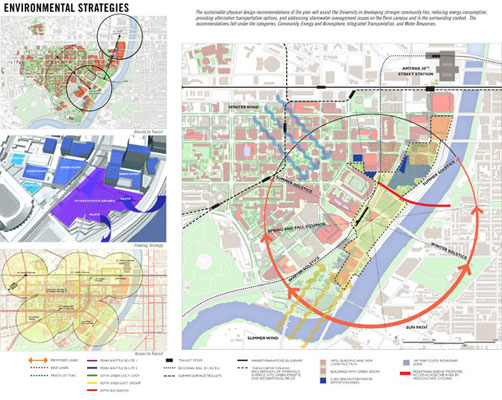
PLANNING, ENVIRONMENTAL,
AND DESIGN ISSUES
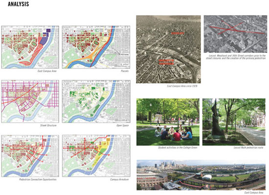
The east campus area presents a
number of development opportunities and constraints
that are addressed in the Vision Plan:
Iconic Structures – the east campus
area includes Franklin Field, Penn’s football
stadium, and the Palestra, Penn’s basketball arena.
Both structures are major landmarks and provide several
opportunities for creating new public gathering spaces.
Transportation corridors – a series
of transportation corridors traverse the east campus
area, listed from west to east as follows: the SEPTA
regional transit line connecting 30th Street Station
and the Airport; the Highline freight railway, which
is elevated some 60 feet above the ground plain on a
combination of stone and steel supporting elements;
the northeast rail corridor of AMTRAK; and Interstate
76. Combined, these corridors segment the east campus
land into several disconnected parcels, many of which
are difficult to develop as a result of irregular and
triangular configurations and the lack of direct access
from the roadway network. Further, they limit opportunities
for ground level north/south circulation through the
east campus area.
100 Year floodplain of the Schuylkill
River – the Schuylkill River floodplain covers
several acres of the east campus area, further limiting
the development potential of the land, and resulting
in the need to elevate much of the proposed development
on parking structures.
Bridge and surface road network
– the existing roads serving the east campus area
occur at the level of the Walnut and South Street Bridges,
which cross the Schuylkill River; and the surface roads
beneath the bridges, which include Lower Walnut Street
and Lower 31st Street.
PROJECT METHODOLOGY
Penn engaged in a year long planning process to develop
a vision for integrating the acquired land into the
campus environment. The process was guided by the Campus
Development Planning Committee (CDPC) and involved multiple
consultations with members of the campus community and
public representatives. Data and planning information
was provided by the University’s staff of professional
landscape architects, planners, and architects. A total
of six development options were developed for integrating
the acquired land for the highest and best purposes.
Each option was evaluated utilizing criteria for sustainability,
design, operations, implementation and cost. Based on
the comments received, three options were selected
for further exploration ultimately leading to the selection
of the concept that inspired the master plan. The landscape
architects were engaged in the design direction for
the public realm including streetscapes, parkland, and
pedestrian routes for the entire campus. In subsequent
phases, the firm was engaged in the design development
process for the urban park and sports fields proposed
for the acquired land along the Schuylkill River corridor.
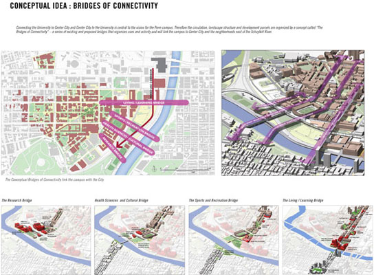
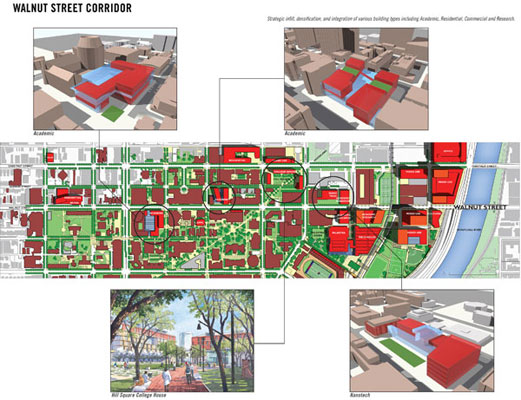
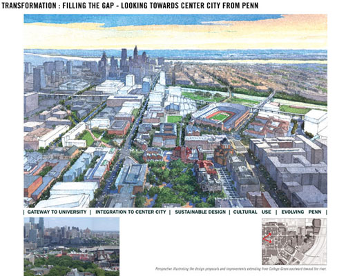
CAMPUS VISION
Connecting the University to Center City and Center
City to the University is central to the vision for
the Penn campus. The Vision Plan provides guidance for
the east campus area as well as several other infill
and redevelopment sites along the Walnut Street corridor
and in the established core of the Penn campus.
The circulation, landscape structure
and development opportunity sites of the Vision Plan
are organized by “The Bridges of Connectivity”
– a series of existing and proposed bridges that
link the campus to Center City and the neighborhoods
east of the Schuylkill River. Conceptually, the bridges
are viewed as armatures for major physical improvements.
Each bridge integrates the east campus lands with the
core campus and Center City to create a flexible framework
for accommodating current and future development needs.
Each bridge thematically organizes uses and activities:
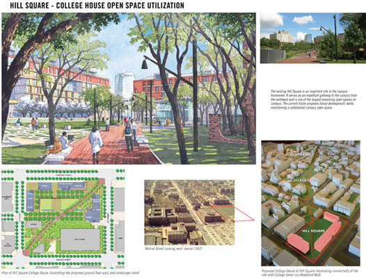
- The Living/Learning Bridge
– the Walnut Street corridor is transformed
in the plan through a combination of infill and new
development to create a new gateway to the campus
from Center City. It accommodates a mix of academic,
research, residential, cultural, and support amenities
that address programmatic needs and contribute to
the overall quality of the pedestrian experience.
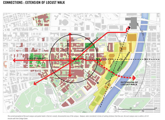
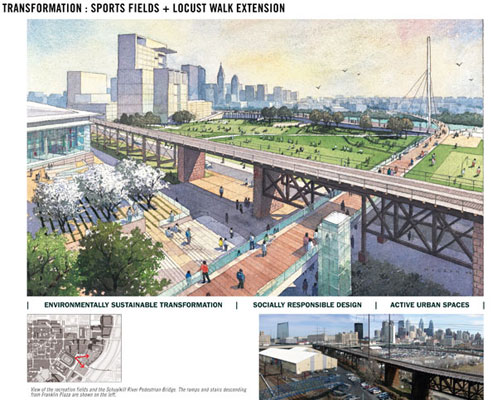
- The Sports and Recreation Bridge
– a new pedestrian bridge over the Schuylkill
is envisioned as a continuation of Locust Walk, which
will be extended eastward to engage two major new
public gathering spaces adjacent to the Palestra and
Franklin Field: Palestra Green and Franklin Plaza.
A concentration of new sports and recreation facilities
will flank the bridge, including a renovated Palestra,
a new field house, and several new sports fields constructed
on the east campus/postal lands.
- The Cultural and Health
Sciences Bridge – the South Street
Bridge is envisioned as the cultural and sports gateway
to the campus. The planned reconstruction of the bridge
by the City provides the opportunity to line the street
with new uses related to the cultural functions of
the Museum of Archaeology and Anthropology and provide
better connections to the adjacent Medical District.
A combination of streetscape improvements and new
uses, including small scale cultural facilities, amenities,
and sports fields, will transform the pedestrian experience
along the reconstructed bridge.
- The Research Bridge
– a new pedestrian bridge is proposed to connect
Penn’s Medical District with east campus lands
to accommodate new medical and research uses over
the long term. The bridge will be coordinated with
a new green space, Museum Plaza, designed to provide
public space in this dense area of the campus, a direct
and visible pedestrian route to University City transit
station, and a visual connection to the river.
CIVIC STRUCTURE
The proposed civic structure of the east campus area
is based on a new framework of open space and circulation
routes which collectively link the land to the core
campus and the surrounding urban context. Major new
public space proposed in conjunction with the pedestrian
circulation network includes:
- Palestra Green, located to the west of
the Palestra, serves as the gateway to the east campus,
is envisioned as a new public space providing passive
recreation opportunities, a gathering space for major
events, and a foreground landscape for the iconic west
façade of the Palestra.
- Franklin Promenade and Plaza,
located to the north of the stadium, the Franklin
Promenade is envisioned as the linkage space between
Palestra Green and Franklin Plaza. It will be flanked
by new fitness and recreation uses incorporated into
the arcade of Franklin Field. Franklin Plaza extends
the public space over the SEPTA line to provide access
to the sports and recreation proposed for the east
campus area.
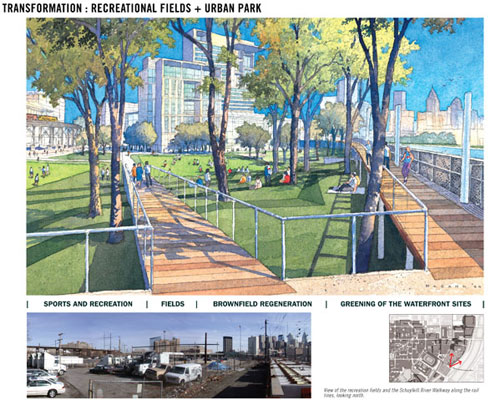
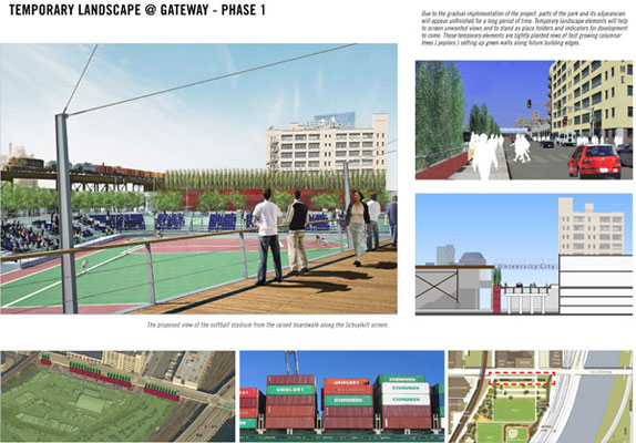
- Sports and Recreation
Fields – the sports and recreation
fields are central to the civic and public space framework
for the east campus area. They are located in a park
environment featuring a series of sculptural landforms
and berms that provide visual and acoustical separation
from the rail lines and I-76. The landforms include
inlets that allow water from the river to flood the
sports and recreation fields during storm surges.
- Museum Green, located
to the south of the Museum, is intended to provide
open space in this densely developed area.
- Plaza over I-76
- a new plaza is proposed over I-76 in the medical
/research expansion district to provide a riverfront
overlook.
The recently completed outcome of
the research and planning process, ‘Penn
Connects: A Vision for the Future’ addresses
the planning and design opportunities for the land and
a flexible phasing strategy to assist the university
in incrementally implementing the vision over the next
thirty years or longer. The Vision plan defines a public
realm of streets, parks, connections, and new buildings
enhancing the presence of the University and the City.
It offers a flexible, pragmatic approach and provides
the initial framework for creating an integrated, mixed-use,
urban district, blurring the perceived boundaries of
Center City and University City.
|