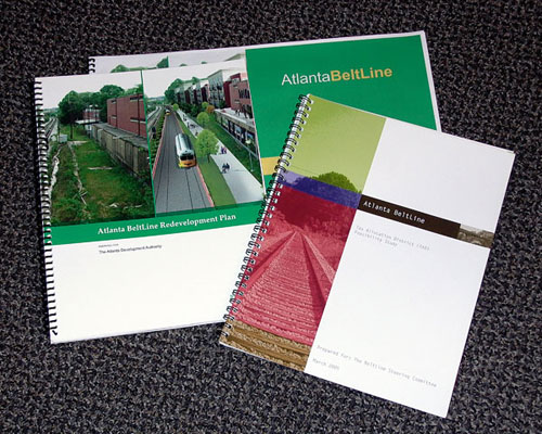
Project Statement
The BeltLine would combine greenspace,
transit, and development along four historic railroad
segments that encircle the urban core of Atlanta. A
Feasibility Study determined that a Tax Allocation District
(TAD) was a feasible financing mechanism. The Redevelopment
Plan then laid out a vision to preserve historic assets,
create parks and trails, and build neighborhood-friendly
transit. In the Fall of 2005, the Atlanta City Council,
Atlanta Public School Board and Fulton County Commission
approved the BeltLine Tax Allocation District. For the
next 25 years, this Georgia ASLA Award winning project
will have major implications for the City of Atlanta.
Narrative Summary:
“We can define the kind of community we will be
in 20-30-40 years…greenspace, walkability, transit,
new intown development. It will, with its full implementation,
take us to the next level of great American cities.”
Mayor Shirley Franklin,
July 12, 2005
Project’s Goals
and Objectives: The BeltLine is one of those
rare projects that has the extraordinary potential to
transform the City of Atlanta. Over the previous two
decades, the metro region has grown as quickly as any
major metropolitan area in recent U.S. history. But
the region’s growth has come primarily in the
form of widely spread, disconnected pockets of development.
Increasingly, residents and businesses throughout the
region experience the negative consequences of such
unplanned growth—long commutes, poor air quality,
auto dependency, and limited public space. Moreover,
this sprawl has led to uneven economic activity. While
the region has experienced unprecedented growth and
job creation, many areas within the city of Atlanta
have suffered from urban flight and disinvestment.
The city of Atlanta is expected
to grow by another 150,000 residents by 2030, while
the region will expand from 3.7 to 6 million people.
However, not all of Atlanta’s communities have
participated fully in the region’s unprecedented
growth. Many core neighborhoods, particularly in the
south and west, continue to suffer from economic disinvestment.
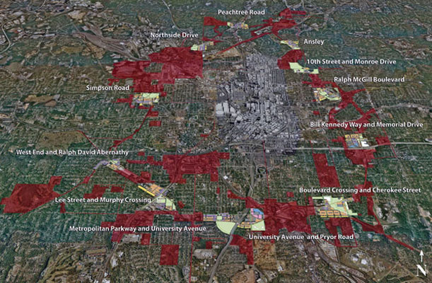
The BeltLine Redevelopment
Plan combines greenspace, trails, transit, economic
revitalization, and new development along 22 miles of
historic rail segments that encircle the urban core.
These rail rights-of-way and nearby properties form
the footing (or foundation) of an unrivaled network
of distinctive buildings, public spaces, and convenient
transportation links that could join over 45 historic
neighborhoods and many prominent institutions. By attracting
and organizing some of the region’s future growth
around public amenities and mobility choices close to
the inner core of Atlanta, the BeltLine seeks to reverse
the long-standing pattern of regional sprawl and create
a more vibrant and livable city for all residents.
As a truly sustainable new
model of urban growth, the BeltLine combines many interrelated
elements of planning and urban design. The project will
preserve the historic structures that reflect Atlanta’s
origins as the rail and industrial hub of the southeast.
It will add nearly 1,300 acres of new greenspace, ranging
from grand parks to intimate plazas and gathering spaces,
and 33 miles of connected trails and greenways. The
Beltline will build neighborhood-friendly transit, clean
up brownfields and re-use neglected industrial properties,
and spark quality mixed-use growth and workforce housing
in all parts of the city.
Environmental and
Social Data Analysis/Methods of Analysis: The
BeltLine Redevelopment Plan proposes to achieve these
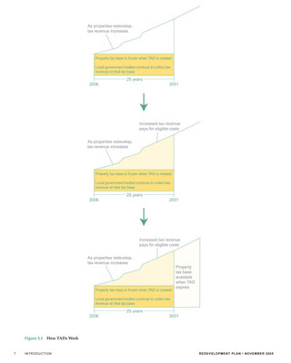
goals through a Tax Allocation District (TAD). More
commonly referred to as a Tax Increment Financing District
in other states, the TAD is a special financing mechanism
that allows local governments in Georgia to use increased
property taxes from new projects to issue bonds that
will, in turn, fund specifically designated redevelopment
activities in that district. In the case of the BeltLine
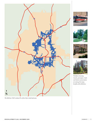
Redevelopment Area, the TAD includes the 22 mile rail
corridor and its mostly industrial adjacent property,
equaling about 6,500 acres (or eight percent) of the
city’s total land area.
The Redevelopment Plan is
the statutorially required product of the Redevelopment
Powers Law, which enables the formation of a TAD. The
document lays out the physical boundaries of the TAD,
the vision for redevelopment in the area, the funding
capacity, and priorities for action. Perhaps more critically,
the BeltLine Redevelopment Plan is an expression of
a broad public discussion of land use, greenspace, transportation,
housing, equity, and overall quality of life in the
city.
The plan analyzed development
districts that will include:
- Parks—over 1,200 acres of new
or expanded parks, as well as improvements to over
700 acres of existing parks;
- Trails—33 miles of continuous
trails connecting 40 parks, including 11 miles connecting
to parks not adjacent to the BeltLine;
- Transit—22-mile transit system
connecting to the larger regional transit network,
including MARTA and the proposed Peachtree-Auburn
Streetcar;
- Jobs—more than 30,000 permanent
jobs and 48,000 year-long construction jobs;
- Workforce housing—5,600 new
workforce housing units;
- Streets—new and renovated streets
and intersections including 31 miles of new streetscapes
connecting neighborhoods and parks to the BeltLine;
- Environmental remediation—clean-up
of sites with environmental issues;
- Neighborhood preservation—preservation
of existing single-family neighborhoods by providing
appropriate transitions to higher-density uses;
- Tax base—an estimated $20 billion
increase in tax base over 25 years; and
- Industrial base—preservation
of viable light industry.
How Options were Considered/Involvement
of Interested Parties: The Redevelopment Plan
sought to gather public feedback and build broad community
consensus for an overall vision of the BeltLine and
its extraordinary opportunity. In many ways, the Redevelopment
Plan and the accompanying public involvement and planning
were as close as Atlanta has ever come to a city-wide
examination of land use, development, greenspace, and
transportation issues.
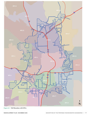
The public planning process in Atlanta
revolves around a series of 24 neighborhood planning
units or NPUs. Recognizing the diversity of the BeltLine,
the team aggregated the individual NPUs into four main
geographic areas based on similar social, economic,
and neighborhood issues. During an intensive six-month
process beginning in May of 2005, the planning team
conducted an aggressive and comprehensive campaign to
engage all stakeholders and interested parties. In May,
June, and July residents attended a series of workshops
designed to orient them to the BeltLine planning process,
explain the complexities of TAD financing, and identify
their concerns about land use, transportation, parks,
and economic development in their communities. Facilitators
assigned participants to small groups that examined
various issues and proposed goals, priorities, and concepts.
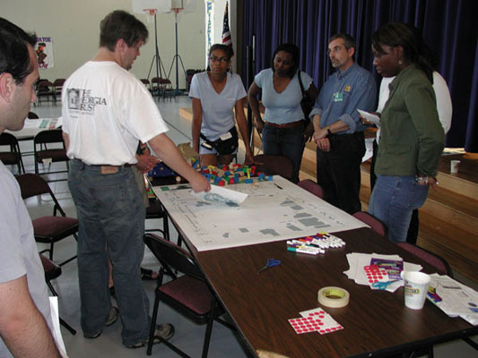
To create a hands-on and readily accessible experience,
facilitators asked participants to draw on maps and
place building blocks on base maps to create scale-appropriate
models of development. The feedback from these workshops
became a critical part of the vision as articulated
in the Redevelopment Plan and Development Guidelines.
The team relied on other innovative techniques
to convey complex information to the public and generate
meaningful dialogue, including: two 12-minute videos
that traced the background of the BeltLine, established
goals and priorities, and laid out steps for future
action; and a series of narrated bus tours along the
corridor to highlight the individual development and
greenspace opportunities in each of the four NPU areas.
To receive specific input from the public on draft materials,
the team also met with neighborhood groups and NPUs
on a small group basis as part of scheduled office hours.
The variety of public involvement forums allowed for
comments ranging from broad concerns over quality of
life to specific input on recommended projects.
Along with wide public involvement, the
team collaborated extensively with government, regional,
private, and non-profit stakeholders, including the
City of Atlanta, the Atlanta Regional Commission, the
Metropolitan Atlanta Rapid Transit Authority (MARTA), the Trust
for Public Land, the PATH Foundation, and a specially
created BeltLine coordination entity—the BeltLine
Partnership. The BeltLine Partnership, for example,
convened a panel of experts from the fields of development,
workforce housing, planning, design and architecture,
market research, greenspace, and community improvement
to review preliminary recommendations and refine assumptions.
Overall, the planning team participated in more than
80 total individual meetings involving more than 1,600
participants during the six-month effort. The resulting
document truly constitutes a shared vision for the future
of Atlanta.
How Design was used in the Process:
The Redevelopment Plan uses design to create a broad
framework for integrated land use, greenspace, trails,
parks, and critical transit and pedestrian links throughout
the BeltLine corridor. The framework promotes consistency
with several overarching land planning principles, including:
creating active mixed-uses all along the corridor; introducing
more intense land uses in key areas to support transit
demand; establishing suitable transitions from development
to nearby single-family residential areas; enhancing
access with a series of new streets, trails, and streetscapes;
and encouraging connected greenspaces to capitalize
on existing natural amenities and to frame new residential
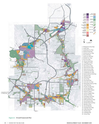
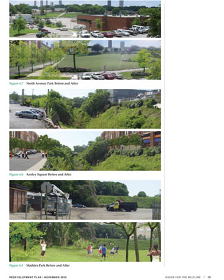
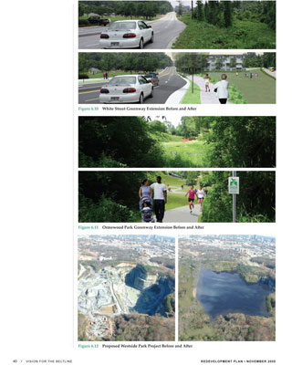
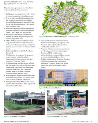
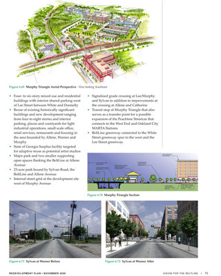
opportunities. The Redevelopment Plan is a highly graphic
document intended to convey the desired character of
the BeltLine through a series of Geographic Information
System–based maps, conceptual maps of the overall
vision, before and after simulations of park and development
opportunities, and a series of aerial sketches and site
plans for 12 prototypical activity centers spread evenly
across the BeltLine. The accompanying Development Guidelines
illustrate the desired relationships of buildings to
the public realm, connectivity and greenspace standards,
transitions to single-family neighborhoods, and preservation
of the corridor’s very unique historic and industrial
character.
Project Implementation/Administration
+ Monitoring: In October, the planning team
completed the Redevelopment Plan and the document began
a process of formal legislative consideration before
the three participating government entities—the
Atlanta City Council, the Atlanta Public School Board,
and the Fulton County Commission. By December 21, 2005,
all three jurisdictions adopted the plan, putting into
place a formal financing mechanism that is anticipated
to raise as much as $1.7 billion over the next 25 years.
The BeltLine TAD funds will be generated
by new growth in the tax base within the defined TAD
Redevelopment Area. Based on this growth, and as private
development begins, bonds will be sold and the proceeds
will be used to fund a portion of the total cost for
acquiring land and building parks, trails, transit, and
other government projects. (The bonds are secured by
the anticipated growth of the tax base within the TAD;
the taxpayers of the City of Atlanta will not be obligated
to repay the bonds.) The remaining portion of the project
costs is expected to be funded through various philanthropic
and federal sources.
Already many business and non-profit groups
are coming together to begin implementation of the BeltLine.
The Trust for Public Land and the PATH Foundation are
planning, acquiring, and locating new parks and paths.
MARTA is working on the desirable mode for transit.
Under the umbrella of the BeltLine Partnership, implementation
and fundraising are beginning to take shape. The implementation of the BeltLine will continue to
be a community-based effort with plans for ongoing neighborhood
participation, special advisory committees created to
guide policy for areas such as affordable housing, a
proactive historic preservation plan to protect key
resources, and the development of quality of life indicators
to monitor progress.
This Redevelopment Plan describes
one of the most exciting, but complex projects in Atlanta’s
history. As the BeltLine will take 25 years to implement
fully, this Plan provides a framework for moving forward.
It outlines the major public infrastructure projects
that comprise the BeltLine project. It outlines the
type and scope of development that is consistent with
good planning practices. It demonstrates the feasibility
of the TAD to create a majority of the necessary funding
(based on the proposed development). But the Plan also
anticipates the need for continued public dialogue and
decision-making about issues as diverse as the timing
of bond issuances; the design and development of parks
and trails; the exact route of the public transit system;
more detailed land use plans; and a host of other critical
issues. It has taken hundreds of meetings and conversations
within the Atlanta community to get to this point, and
there will be many more public meetings and plans over
the next 25 years discussing implementation. The Redevelopment
Plan is the necessary first step on the long road to
making the BeltLine vision a reality. The BeltLine—by
attracting and organizing some of the region’s
future growth around parks, transit, and trails located
in the inner core of Atlanta—will change this
pattern of regional sprawl and lead to a vibrant and
livable Atlanta with an enhanced quality of life for
all city residents.
 |
|
Project
Resources |
|
|
Planning:
Stanford Harvey, AICP, Urban Collage, Inc.
Transportation Planning:
John J. Funny, Grice & Associates,
Inc.
Tax Allocation/Financial
Feasibility:
Rick Padgett, Huntley Partners
Legal:
David C. Kirk, Troutman Sanders LLP
|
|
|
|
Design:
Ryan Gravel, Gravel, Inc.
Watercolor Renderings:
Rebekah Adkins, Savannah College of Art
and Design
Video Production:
Donata Renfrow
|
|
|
 |
|