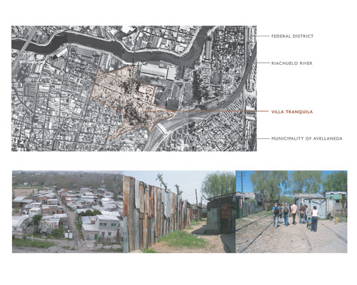
The site of our project is a squatter settlement known as "Villa Tranquila," which
occupies 60 acres in the municipality of Avellaneda, near the center of the
city of Buenos Aires, Argentina. Villa Tranquila is home to 7000 people, almost all of whom are living illegally in
self-constructed, substandard housing. This villa represents only 1% of the
total population living in shantytowns within the greater metropolitan area of
Buenos Aires.
Our study of Villa Tranquila encompassed research and a week-long studio trip,
during which we were escorted through the community by leaders of the villa who
had already formed a relationship with members of the municipality doing work
inside. Since the villa is governed internally (police do not enter the settlement), this protected visit afforded
us a unique opportunity to speak with residents and to observe site conditions. In our analysis, we explored the existing
social and environmental conditions to gain an understanding of proposed
municipal and locally improvised solutions to the problems of sanitation,
security, connectivity, shelter, and open space. The goal of our project is to produce a set of landscape
strategies that could be employed both by the individuals in the community and
by the municipality to direct the growth and development of Villa Tranquila,
creating a precedent for other squatter settlements in the city.
Background
Although it is known as an "emergency" settlement, Villa Tranquila has existed for
almost 100 years. The community lies on the banks of the Riachuelo, a river
known to the city as "dead" because of its toxic levels of contamination from
local industry. The villa's population has fluctuated in concert with the volatile politics and economy of the
country, and has most recently experienced a massive influx of individuals left
homeless by the economic crash of 2001. Many of the villa's residents were historically employed at the nearby
industrial and manufacturing plants along the Riachuelo, but as industry has
moved out of the city, more than 50% of the villa's residents have become
unemployed. A plant formerly operated by Unilever remains abandoned on the edge of the community.
The extent of physical and social volatility for the residents of Villa Tranquila has prompted
the municipal government of Avellaneda to initiate a revitalization program for
the settlement. The municipality has already begun to implement a program that removes
precarious housing, fills in flooded areas, and constructs new housing on the
fill. The municipality's plan proposes to cut the city grid through the fabric of the villa, with sidewalks and new
pipes for running water and sewers following the new streets. It also proposes revitalizing the Unilever factory
as a community center and reopening the defunct rail line that runs through the
settlement, reconnecting the villa with the central district of the city.
We find several major flaws in the municipality's plan for the future of Villa Tranquila. Members of the community that we spoke with
expressed distrust in the project because it relies entirely on the municipal
government for its implementation. Having experienced a long history of projects being abandoned when a new
party comes into office, residents were reluctant to believe that the
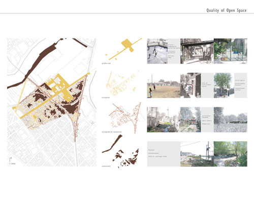
municipality's plan would come to fruition. Furthermore, we believe the plan does not respond to the existing fabric
of the villa, which reflects the types of open spaces that function and are valued
by this community; rather it superimposes the city grid and open space typologies
that are not of the place. Most significantly to our project, the municipality has not taken an informed
watershed approach to the realities of topography and water on the site.
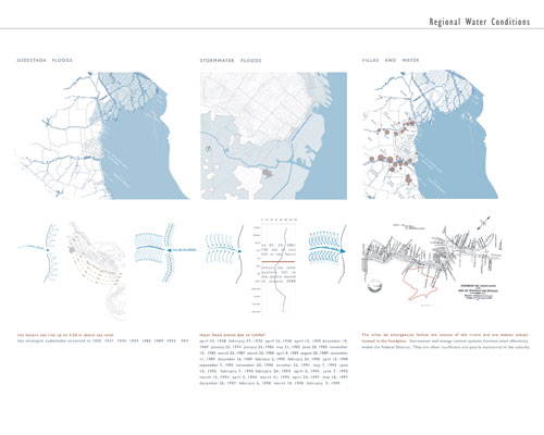
A Watershed Approach
Many
of the health and quality of life issues in Villa Tranquila are integrally tied
to water. In the villa's current condition, sewage is carried through open channels, potable water is
contaminated and trash is dumped in common spaces. Stormwater mixed with sewage and trash floods homes and public
spaces, resulting in attitudes which devalue water and lead to further
degradation of common space. Buenos Aires suffers a particular type of storm known as a "sudestada," which sends a
wall of water upriver, drastically flooding the city every several years. More frequently, Buenos Aires receives
intense, heavy rainfall, flooding the city within hours. Because the Riachuelo's edge is higher in
elevation than the villa, when flooding occurs, water is unable to drain back
into the river. As density in the villa has increased, areas which are only barely habitable have increasingly been
occupied, such as constantly wet areas and wedges of land between train tracks. The municipality has begun filling some
flooded areas to build new housing, but this has caused flooding up to 4' in older
areas of the villa that were previously dry.
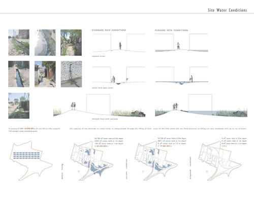
Our project proposes the complimentary use of non-formal and
institutional solutions to address the problems of contaminated potable water,
stormwater and river flood control, sewage removal, and trash disposal. This strategy creates a network of drainage
and open space that is locally maintained. The generation of this open space network will improve living
conditions, generate opportunities for local business and employment and increase
connectivity within the villa and to Avellaneda and the Federal District. By directing the flow of stormwater, program
can be introduced to previously flooded and unused land, creating the opportunity for villa residents to reclaim and value those spaces. Spaces initially reclaimed for a specific
purpose, such as a shared clean water tap, may change their function over time
and become part of a greater network of social spaces. Ideally the villa would eventually become
integrated into the city; however, if the government were unable to provide
formal infrastructure to the settlement, the residents would have a series of
internally sustainable landscape strategies that would vastly improve the
conditions of the settlement.
Emergency Long Term Strategies
Historically, the Federal District of Buenos Aires utilized
a system of "open construction" to control stormwater, using public open space
as an integral part of the drainage network.
The city acknowledged the limitations of its institutional system and
planned for public open space to double as a stormwater overflow system. Because the fabric of the villa does not
lend itself to traditional infrastructure and the capacity of the municipal
infrastructure is currently inadequate, we propose that some of the non-formal
solutions continue into the long term, becoming an integral part of the villa's
infrastructural network.
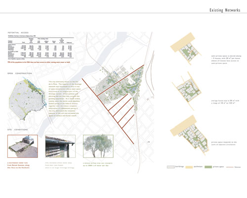
We analyzed existing relationships among houses, roads,
public space, and private space as a basis both for our approach to intervening
in the existing fabric of the villa and for designing new villa fabric. Not only did we consider the existing
housing, but also the potential growth of the villa population in the
future. Our strategy is therefore two fold: phases one through three propose the development of an open space system
for areas of the villa where the condition of the housing is amenable to
upgrade, while phases three through five propose a system for the siting of new
housing which is sensitive to watershed issues and which is integrally connected
to the upgraded areas. It is our intention to propose an open space system with
a measure of flexibility to accommodate multiple programmatic needs in
different parts of the villa. It is a phased approach from short-term, low-tech insertions to longer-term,
infrastructural changes.
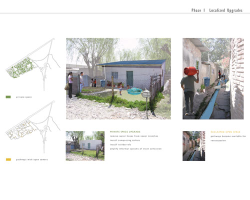
Phase One: Localized Upgrades
In phase one, composting toilets are installed locally so
that sewage no longer runs through the pathways and contaminates potable water
hoses and public spaces. Rain barrels
are also installed at each home to collect stormwater for washing dishes and
watering plants. The informal system of
trash collection is amplified.
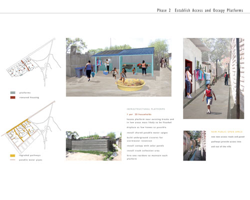
Phase Two: Establish Access and Occupy Platforms
In phase two, plazas are strategically opened in low areas that are most likely to be flooded, such
that the open space network can double as stormwater overflow system. Beneath each platform, a cistern will be
installed to hold stormwater, heated by solar energy, for such uses as fire protection,
cleaning, laundry and cottage industries. One resident will be hired to
maintain each plaza. Platforms are inserted such that there is one for approximately every 25 houses. We determined this number based on existing
conceptions of "neighborhood" size within the villa made evident by upgrades
such as smaller pieces of paved pathways.
New access roads are opened where possible to provide
strategic access into and out of the villa. Roofs on houses are upgraded and pitched to drain towards the pathways. Pathways are graded and paved to direct
stormwater to the cisterns, and pipes are laid for potable water beneath the
paths. Trash collection areas and clean potable water taps will be installed at each platform. Small-scale program (daycare, clubs, kiosks,
playgrounds, cottage industries) can develop through time based on the
localized needs of the residents. Because of the consolidation of water, some of the smaller, lower areas
of the villa will no longer collect standing water, providing additional spaces
for housing and program.
Phase Three: Create Drainage Network for Existing and New Villa Fabric
In phase three, a swale system is constructed to connect the
platforms in the existing fabric creating a linked open space system. These swales collect and hold additional
stormwater, draining eventually to larger swales along the train tracks. This will be accomplished by removing as few
homes as possible and without taking away any home's access to private
space. The enlargement of the open space system will enable the drainage of standing water and the consequential clean-up
of existing lowlands to make them available for larger scale program (soccer
fields, community buildings on stilts such as a training center, a center for
older residents etc.). Because these areas remain low, new program will be built with the assumption that it will
flood, accommodating overflow stormwater during major storm events.
In the areas to be developed with new villa fabric, houses
that are immediately along the railways are removed in stages such that new
housing is always constructed before people are displaced. The residents removed first will be
immediately housed in the municipality housing that is already being
constructed in the eastern part of the Unilever site.
A drainage system will be constructed to enable previously
standing water to flow. Large swales, planted with young willows that rapidly transpire stormwater, are built
alongside the train tracks, doubling as a protective measure to separate the
housing and walkways from the tracks. A circulation system moves along the swales and widens at strategic points to
create semi-public spaces used for socialization, economic generation, and
localized services, such as garbage collection. This new drainage system will
allow the flooded areas to be reclaimed by the villa as space for housing, open
space, and program. When it reaches the main street, water collected by the swales will be piped to an on-site water
treatment facility to be treated for use as potable water in the villa. This facility both promotes the idea of
local sustainability for the villa and provides job opportunities for its
residents.
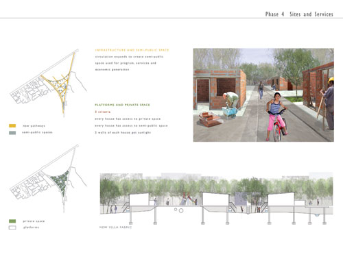
Phase Four: Sites and Services
In phase four, garbage will be removed from the lowlands and
vegetation will be selectively removed, maintaining canopy willow trees to
shade private spaces and transpire water. Existing pathways will be extended perpendicular to the main street. Soil
cut from the swales will be used to create raised berms so that in major rain
events when the spaces do briefly flood, the villa's roads, homes, and social
spaces are not inundated. Breaks in the berms allow water to flow to the major swales.
Sewage and potable water pipes will be laid under the pathways to
service the future housing. Widened pathways will also become opportunities for active program such as sports
fields, daycare, markets, clubs, and kiosks. Public spaces are connected to
create a greater greenway drainage system. Boardwalks above the drainage channels connect the berm pathways, to the
greater open space system.
New housing will then be constructed along the new
pathways. The scale and configuration of existing fabric and our proposed upgrades inform the design of the new
housing. Houses will be elevated on stilts such that their front doors meet the raised berm pathways, but their
back doors step down to private spaces shared by four to six homes, as in the
consolidated areas. Each house will have a rain cistern to collect stormwater so that it can be re-used.
Phase Five: Growth of the Villa
As the villa grows and municipal
infrastructure is (potentially) introduced over time, the platforms first
established as centers for basic services take on multiple programmatic functions,
such as playgrounds, marketplaces, and cottage industry locations, as
determined by the needs and interests of residents in their surrounding
neighborhoods.
|