Our studio project concerns New Orleans. We address the problems
revealed after Hurricane Katrina hit New Orleans in August 2005. More precisely
the questions we try to answer are: Is the current ecological balance of water
and dry land sustainable in New Orleans and if not can it ever be? What went
wrong and when as New Orleans kept expanding? In which ways can we make New
Orleans a sustainable environment that can treat phenomena such as Hurricane Katrina
and Mississippi floods as natural, and not as a disaster?
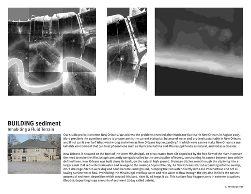
New Orleans is situated on the bank of the lower Mississippi, an
area created from silt deposited by the free flow of the river. However the
need to make the Mississippi constantly navigational led to the construction of
levees, constraining its course between two strictly defined lines. New Orleans
was built along its bank, on the natural high ground. Drainage ditches went
through the city tying into a larger canal that redirected rainwater and sewage
to the swamps beyond the city. As New Orleans started expanding into the swamp,
more drainage ditches were dug and soon became underground, pumping the rain
water directly into Lake Ponchartrain and not allowing surface water flow.
Prohibiting the Mississippi overflow water and rain water to flow through the
city also inhibits the natural process of sediment deposition which created
this land, rises it, ad keeps it up. This surface flow happens only in extreme
occasions (floods), depositing huge amounts of sediment (today called debris).
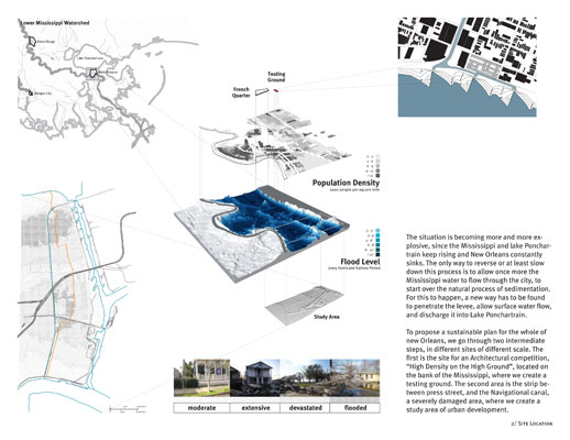
The situation is becoming more and more explosive, since the
Mississippi and lake Ponchartrain keep rising and New Orleans constantly sinks.
The only way to reverse or at least slow down this process is to allow once
more the Mississippi water to flow through the city, to start over the natural
process of sedimentation. For this to happen, a new way has to be found to
penetrate the levee, allow surface water flow, and discharge it into Lake
Ponchartrain.
NEW ORLEANS
Our aim is to build canals through New Orleans that connect the
Mississippi to Lake Ponchartrain. These canals will discharge water throughout
their course into the bowl of New Orleans (created between the levees of the
Mississippi and those of lake Ponchartrain), and it will drain tidally into the
lake.
To propose a sustainable plan for the whole of New Orleans, we go through two intermediate
steps, in different sites of different scale. The first is the site for the
Architectural competition, "High Density on the High Ground", located on the
bank of the Mississippi, where we create a testing ground. The second area is
the strip between Press Street, and the Navigational canal, a severely damaged
area, where we create a study area of urban development.
THE TESTING GROUNG
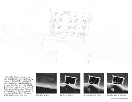
In the site for the Architectural competition, "High Density on
the High Ground", located on the bank of the Mississippi, we create a testing
ground that allows the water from the river to enter it tidally. On this site
we place a research center of Tulane University to measure the amount of silt
deposited by the river, according to the amounts of water let in, the seasons
of the year, the level of the river.
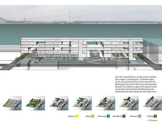
On top of the testing ground we place a cat-walk that
concentrates all public activities (retail, communal, entertainment) as well as
parking space. Over the catwalk there is a high density residential complex,
consisting of 1-3 bedroom apartments. All apartments have a view towards the
Mississippi river and at least two sides exposed. All public circulation is
open air facing the north, and on the south towards the Mississippi are located
private open spaces for each apartment.
THE STUDY AREA
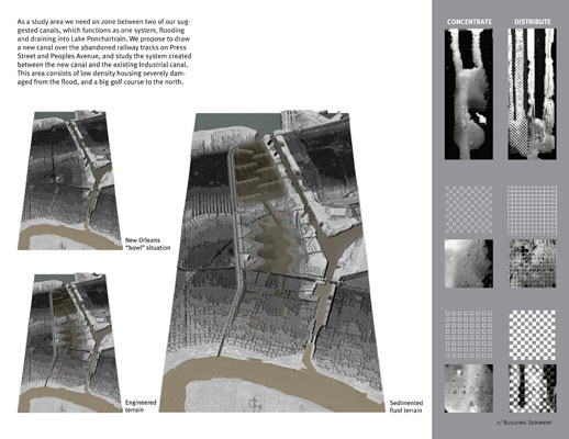
As a study area we need a zone between two of our suggested
canals, which functions as one system, flooding and draining into Lake
Ponchartrain. We propose to draw a new canal over the abandoned railway tracks
on Press Street and Peoples Avenue, and study the system created between the new
canal and the existing Industrial canal. This area consists of low density
housing severely damaged from the flood, and a big golf course to the north.
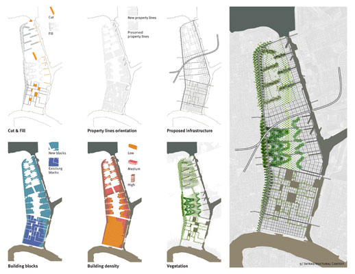
There are 3 different ways of discharging water into the city:
-
Between Lake Ponchartrain
and the Gentilly Ridge, a wet, constantly rising high-ground is built, and a
wetland that fills, and drains tidally into the Mississippi.
-
Between the Gentilly Ridge
and the existing high-ground, we propose to construct mounds along the canal,
and discharge water between them, creating a wetland constantly nourished with
sediment from the Mississippi.
-
Through
the existing high ground, we propose to dig canals into the existing fabric,
and locate open spaces where water can concentrate.
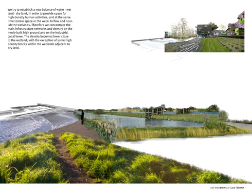
We try to establish a
new balance of water - wet land - dry land, in order to provide space for high
density human activities, and at the same time restore space or the water to
flow and nourish the wetlands. Therefore we concentrate the main infrastructure
networks and density on the newly built high ground and on the industrial canal
levee. The density becomes lower close to the wetland, with the exception of
some high density blocks within the wetlands adjacent to dry land.
|