Introduction
"Two Islands Park" is an evolving park displaying changes in
the landscape through artificial and natural methods. The park aims to educate
visitors about contamination, to support the surrounding region's leisure
activities, and to revitalize the region by remediating the landscape into a
local amenity. The park utilizes remediation strategies as tools to relate the
social and ecological aspect of remediation with the local region.
Location and Context
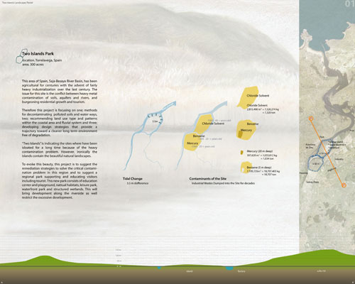
The site of "Two Islands Park" is located in the Saja-Besaya River Basin estuary
approximately forty-five minutes away from Bilbao Spain. Historically an
agricultural region, the advent of heavy industrialization created severe metal
contamination. Today, this contamination conflicts with bourgeoning residential
growth and tourism interests.
Although
conceptually divided into two islands, "Two Islands Park" is a 300 acre site
consisting of one island and the surrounding area within the upstream region of
the Saja-Besaya River Basin. Current land use is a mixture of agricultural,
industrial, residential zones. Waste dumping by local industries created the
site's major problem of mercury, chloride solvent and benzene contamination
within the soil and water. The contamination prevents any exploration of the
island's beautiful landscape layers. Asturiana de Zinc, a sulfur dioxide factory
located within the site, will suspend industrial production in 2010. With the
factory's closure, design strategies are necessary to provide new land use and
associated remediation strategies.
Main Issues and Concept
Remediation strategies are first discussed in order to
rehabilitate the land to support new activities and to develop the region's
potential to transform into local attraction. The park aims to educate visitors
about contamination issues and to provide visitors with amenities and active recreation
programs. Vestiges such as artifacts from the remediation process will educate
visitors about contamination, while newly introduced land use will illustrate
the resulting benefits of decontamination. Providing vital open space for the
public draws increased numbers of people to the waterfront and will create the
potential for development opportunities that enrich the environment of the
local residents.
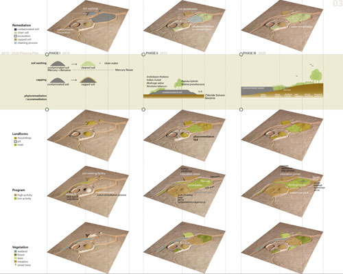
Remediation Strategies
Both the site's land and water require decontamination
before public use can occur. Three methods remediate mercury, benzene, and
chloride solvent out of the contaminated soil: soil washing, capping, and
phytoremediation or ecoremediation. Current research states that only
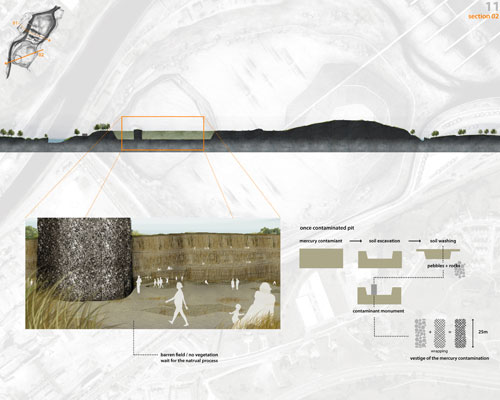
mechanical processes like soil washing are able to remediate mercury.
Therefore, the first remediation strategy introduces this technique to extract
mercury as well as benzene from the contaminated earth. The Asturiana de Zinc
factory building transforms into a soil washing facility after the factory's
closure. The second remediation strategy for benzene and mercury is to cap the
contaminated earth into hills and landforms. The third remediation strategy
consists of phytoremediation and ecoremediation. This method will clean
chloride solvent from the soil slowly but ecologically in order to settle the
soil and create a natural habitat for wildlife. After the soil is remediated,
wetland technology also cleans the contaminated river through a slow but
ecological process.
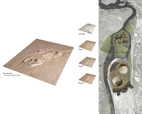
Phase Planning
The phased plan begins in 2010 when the Asturiana de Zinc
factory will close. The park's design and programs will develop over three
phases of five years each. The components of each phase are determined by the
chronological characteristics of the remediation strategies.
Phase I:
The soil washing process relocates the contaminated soil around the site. The
majority of contaminated soil will be cleaned thro ugh the soil washing
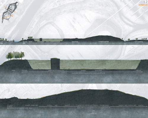
facility while the remaining soil is preserved to create the Contaminant Hill
monument in a later phase. Rock blocks create eco-friendly paths along the
riverside that firmly structure the wetlands adjacent to the river. An entrance
area on the east side of the site will allow visitors to see and understand the
remediation process.
Phase II: Cleaned soil is transported from the soil washing facility
to the wildlife habitat in northern part of the island. Ecoremediation enriches
the soil to create a stable natural system. The southern part of the island
will undergo a phytoremediation process that will take approximately five years
to clean the area. The soil washing facility is reprogrammed into the education
center with a renovated once more with a gallery, visitor's center, and museum.
The Mercury Excavation Pit and the Contaminant Hill, vestiges of the contamination,
open to the public. Highly active sports such as rock climbing and BMX biking
are introduced into the southern part's field. Linear landforms create BMX
tracks that symbolize the soil-drops that developed from trucks during the
transport process. Bike paths along the riverside and a sports field in the
northern part of the site are also constructed within the second phase.
Phase III: Phytoremediation forms patterns that provide the basis for
the road systems within the island. After the phytoremediation, flat terrains
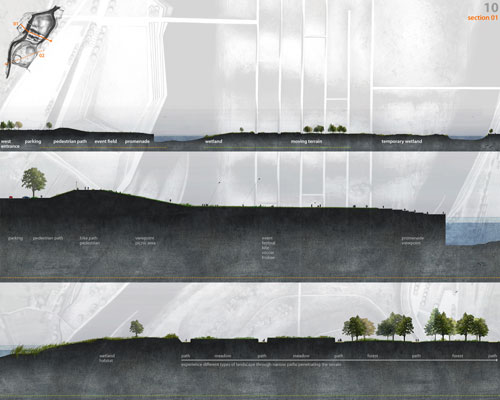
are altered into wavy terrains to augment the presence of tidal changes in the
site. Depending on the 3.5m tidal differences, wetlands emerge and disappear
within the wavy terrain. This emergence and disappearance, called moving terrains,
creates diverse landscapes while naturally cleaning the water. Adjacent areas
to the island will support the local residents through active programs that
draw people to the waterfront. Thicker strips of green spaces and street trees
implemented in this phase will emphasize the pedestrian pathways.
Program
Two main entrances, located at the east and west of the
site, serve vehicles while the sub-entrance, located below the east main
entrance, serves people and bikes. The island's surrounding city context
contains more active programs than the island itself such as education of
contamination and remediation in museum and gallery, festivals and events, kite
flying, frisbee, soccer, baseball, children's playground, picnicing,
experiencing the contaminants of the site, rock climbing, and BMX biking. These
programs will occur within an education center, children's playground, play
lawn, promenade, contaminants experience field, and athletics field. This
surrounding area provides an active waterfront park typically found in major
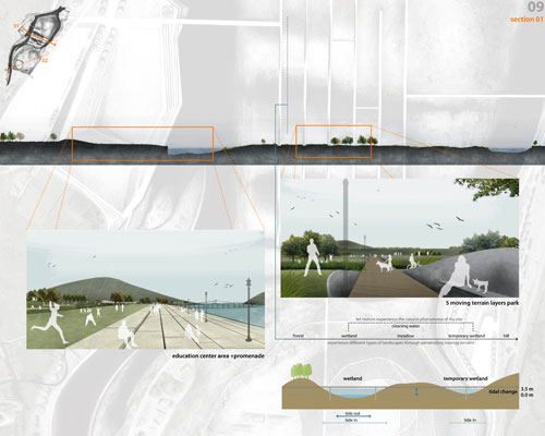
cities. In the island, the Moving Terrain Park serves as a transition area
between the active parks area in the southern section and the wildlife habitat
in the northern section. The Moving Terrain Park allows for walking and playing
on the meadows and wetlands while physical access to the wildlife habitat is
prohibited.
|