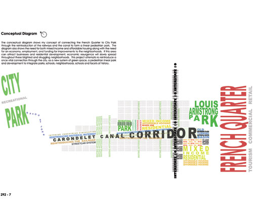
In order to understand the goals and objectives of this project,
one must first discover the past and grasp the effects of history on this
once flourishing landscape. This project reintroduces a once vital connection
through the city as a new corridor that will integrate the surrounding neighborhoods,
parks, schools and facets of history. This area has struggled but is ready
for rebirth. The human and social tragedy that followed Hurricane Katrina
brought social and economic disparity to the forefront of American news, awareness,
and conversation. The corridor will establish a backbone for development
and a spark for economic resurgence.
A Brief History of the Carondelet
Canal
The Carondelet Canal, also referred to as the Old Basin Canal,
was an operational New Orleans canal from 1794 to 1938. In 1794, under Spanish
authority, New Orleans Governor Francisco Luis Hector, Baron de Carondelet,
announced the plan to excavate a canal and construction of the waterway followed.
The canal was to be 1.6 miles long and stretch from Bayou St. John to the
back edge of New Orleans in the Treme neighborhood. A shallow, narrow version
of the canal was completed by the end of 1794 and at that time, the canal
was barely navigable, littered with roots and Cypress stumps. In the following
two years, the canal was widened and deepened and made suitable for small
vessels. In 1797, Governor Carondelet was transferred and by the time of
the American takeover of the city in 1803, the canal fell into disrepair and
deteriorated quickly.
After the Louisiana Purchase, James Pitot worked extensively
to promote improvements to the canal. Beginning in 1805, the Orleans Navigation
Company revitalized the canal and bayou. By the mid-1800s, 70 to 80 vessels
could be found navigating the canal on any given day. At the terminus of
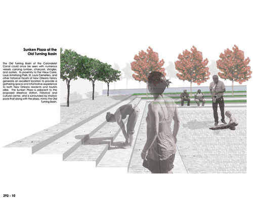
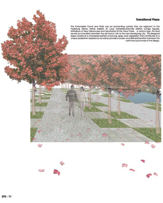
the canal, an 80,000 square foot turning basin was used as a landing depot
for vessels carrying oysters, lumber, charcoal and other building materials.
Warehouses began to line the canal and its importance matured. In the 1830s,
a competing New Basin Canal was constructed. By the time of the Civil War,
the New Basin Canal was doing more than twice the business of the Carondelet
Canal. The canal slowly lost its luster but was still economically important
in the early 1900s due to the oyster business. After the first World War,
use of the canal declined even more and in 1927, New Orleans' first major
canal was declared unnavigable. It was filled by 1938, but remnants of the
canal remained apparent, forming an open swath of concrete and overgrown vegetation
through otherwise densely populated neighborhoods, still making an imprint
upon the geography of the modern city.
A Brief History of Faubourg Treme
At one time, Treme was prosperous and diverse, both ethnically
and culturally. The community is one of our country's oldest African American
neighborhoods and is significant to history as one of the initial communities
to openly house "free people of color." In the days of segregation, Treme
residents were forced to initiate a self-sustaining system of infrastructure,
creating businesses, schools, churches, and forms of social aid. Social Aid
and Jazz Clubs had their members donate to a combined fund so that when economic
struggles existed, residents would have immediate access to economic means
for survival. It can be said that the culture of the Creole people and the
"free persons of color" is rooted deeply in Treme.
In 1730, Fort St. Ferdinand and Fort St. John were established
in what is now Treme. Chevalier Charles de Morand constructed the city's
first brickyard and plantation. By 1780, Claude Treme had acquired most of
the Morand estate. The land was given great value in 1794 when the Spanish
Governor of Louisiana, Baron de Carondelet, announced plans to create a canal
that would connect Bayou St. John to the city. By 1883, Treme had expanded
quickly and there were very few undeveloped lots in the area. Residents settled
into many double shotgun houses and Creole cottages. The community prospered
and produced many of New Orleans' most historically significant landmarks.
Today, poverty infests Treme. The community struggles to overcome
the effect of a series of city and federal projects that have left economic
wounds and emotional scars. "The Treme District in New Orleans is right
next to the French Quarter, within walking distance of Bourbon Street. But
unlike the French Quarter, Treme doesn't have thousands of drunks pouring
money and resources into the community. No, Treme is the neighborhood all
the drunks pass through on their way back to their hotel room, clutching their
purses a little closer and drinks just a little tighter. It's where the only
benefits of Mardi Gras come in the form of drunks pissing on your front steps
or puking their twenty-dollar dinner in your stair well. It's where travel
agencies tell rich tourists they can experience real authentic gumbo and in
the same breath warn against walking the neighborhood at night." - Susana
Adame
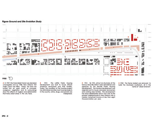
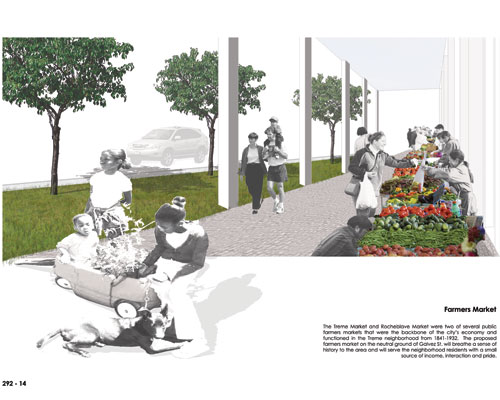
Treme Market
The Treme Market and Rocheblave Market
were two of several public farmers markets that were
the backbone of the city's economy. They functioned
in the Treme neighborhood from 1841 to 1932. The
Treme Market was located on the neutral ground of
Orleans Avenue between Marais and North Robertson
Streets and extended over Villere Street. The market
was built in the 1830s and existed until 1932 when
it was demolished to build the Municipal Auditorium.
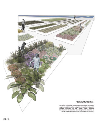
The Lafitte and Iberville Public
Housing Developments
In 1941, the Lafitte Public Housing
Development was built to house African American servicemen
and their families. Today, the condition of the housing
development has diminished and like many housing developments
in the country, it has been infiltrated with crime,
drugs, and poverty. In that same year, all but six
structures of the famous Storyville District were
demolished and replaced by the Iberville Public Housing
Development. This development was originally built
to house Caucasian servicemen and working class families.
The development has since deteriorated and is now
one of the poorest neighborhoods in New Orleans with
a median household income of less than eight thousand
dollars per year.
Louis Armstrong Park, Municipal
Auditorium, and the Theatre of Performing Arts
In the 1960s, the Louis Armstrong Park
and Theatre of Performing Arts were built. Many see
this as an inviting and beautifully landscaped space.
The Treme residents however see a deep wound and the
open scar it left behind. Forty years ago, thirteen
square blocks of houses, stores and jazz and social
clubs were destroyed to make way for the park, theatre,
and cultural center.
Claiborne Avenue and Interstate
10
The neutral ground of Claiborne Avenue
was previously beautiful and park-like. It was ten
blocks long, 100 feet wide and covered about fourteen
acres. The neutral ground was lined with four rows
of mature Live Oaks that totaled about 250 trees.
People would gather, talk, and "embrace each other
in the daily rituals of life." Claiborne Avenue was
lined with businesses and residences and was the center
of culture and economy for African American New Orleanians.
It was arguably the most prosperous African American
business district in the country. In 1966, the Live
Oaks in the neutral ground were cut down, businesses
and residences were demolished, and the prosperous
business district was ignored to make way for Interstate
10. Massive concrete pillars replaced the mature
Live Oaks; the sounds of cars replaced daily conversations.
This construction had perhaps the greatest negative
influence in a series of events suffered by this area
in the past century, bisecting Treme and further diminishing
the desirability of the neighborhood, resulting in
more abandoned properties. Treme has never recovered.
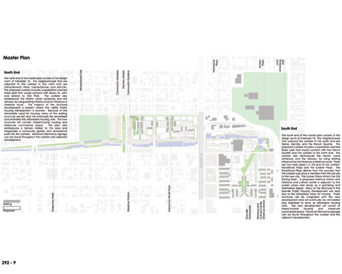
Site Selection
The site of the project is the abandoned
and filled skeleton of the former Carondelet Canal
(Old Basin Canal) that stretches 1.6 miles from Bayou
St. John to the French Quarter. It is a site deeply
rooted in the history of the New Orleans landscape
that is now only a swath of concrete, overgrown vegetation,
and abandoned properties. This swath presents a unique
opportunity to link the French Quarter with City Park,
provide a backbone for economic resurgence, and establish
a corridor that would integrate schools, neighborhoods,
and whispers of history told along the corridor.
The principal challenge of this project
is that all responsibilities, including site selection,
inventory, analysis, and design were previously undefined
and solely an individual assessment. This site was
uniquely challenging in that the deep history and
residents' social and economic struggles and needs
must be embraced while attempting to provide a post-Katrina
New Orleans with a site specific example of how urban
infill can promote positive growth and rebirth to
a city whose future is unknown.
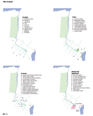
Social Data and Analysis Methods
The needs of this project resulted in
a strong fusion of historical research, site inventory
and analysis, and social and economic census studies.
The data and analysis collected was both on a city-scale
and a corridor scale. I researched the historical
significance of the specific site and all its surrounding
neighborhoods extensively, building a strong foundation
of knowledge that helped to shape and define spaces
and incorporated elements of the past landscape into
the site plan. Site inventory including schools,
churches, parks, and historic districts were defined
using existing GIS data provided by the New Orleans
City Planning Commission. Demographic, social, and
economic data was analyzed and provided by the 2000
U.S. Census. Although the data has been drastically
altered in the aftermath of Hurricane Katrina, the
pre-disaster data offered a basis for the aspects
of inequality, neglect, and struggles that these impoverished
New Orleanians faced in the recent past and continue
to experience. Reports and data produced by organizations
such as the Bring New Orleans Back Commission, Louisiana
Speaks, and FEMA were examined and considered throughout
the course of this project. I also depended on the
knowledge of many individuals including interviewed
residents of the Treme' neighborhood and the City
of New Orleans. I spent many hours walking and driving
the site, speaking with residents, taking detailed
inventory, and photographing the site.
Implementation
The Carondelet Canal
Corridor project would be constructed in a series of
phases determined by the needs of the neighborhoods
residents, and the city. A commitment to funding all
phases would be necessary to ensure that the project
is not abandoned or the vision is only partly accomplished.
The involved parties would include the City Planning
Commission and post-Katrina created organizations.
Residents would need to be involved in the planning
from the beginning stages to ensure that needs and desires
are met. Funding from the city, state and federal governments
would also be essential for the substantial project
to be realized. Priority would be given in Phase One
to the immediate need for housing that would initially
include the selection of minimally damaged structures,
renovation of structures, and the resulting resurrection
of a safe and sustainable environment in the existing
public housing developments. Phase Two would involve
the construction of the physical corridor that would
include the reintroduction of the waterway and railways
for New Orleans street car and pedestrian circulation.
The linear park would begin to connect the French Quarter
with City Park while beginning to provide a backbone
to all future development of the site. Ideally, Phases
One and Two would overlap, helping to resolve the city's
immediate needs and distinguishing a foundation for
the future development of the comprehensive project.
Phase Three would begin to implement the urban infill
needed to spark the economic growth that the area and
city desires. Development would include pockets of
mixed-use retail and commercial space along with mixed-income
and affordable housing units. The identified structures
incorporated in Phase One would be selectively re-established
and divided into affordable housing units for residents
with the required avoidance of gentrification. An essential
quality of the project's success is realizing that full
completion is several years away. Implementation in
a phasing program would provide the corridor with individual,
self-sustainable "communities" within the project as
a whole. This approach provides the opportunity to
establish significant social and economic change in
a timeframe that is as immediate as possible and strengthens
as the project progresses.
In Closing
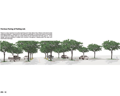
Drainage and shipping canals have been
part of New Orleans' urban fabric for centuries.
In 1794, excavation began for a drainage canal that
by 1817 would be the city's key commercial waterway:
Carondelet Canal. At the turn of the twentieth century,
the Carondelet Canal still served as a local industrial
corridor through the enchanting cityscape which comprised
the French Quarter, Treme Market, Storyville District,
St. Louis Cemeteries, Congo Square and the expanding
Creole Faubourgs such as Treme that were directly
associated with the development and evolution of
jazz.
By 1938, after years of decay and under
use, the canal was filled. Remnants of the canal
remained apparent, forming an open swath of concrete,
unkempt vegetation, and blighted properties through
otherwise densely populated neighborhoods. The canal
helped connect the old city of New Orleans to the
new developing city and provided a link to the rest
of the world for well over a century, and still makes
an imprint upon the geography of the modern city.
This project reintroduces a once vital
connection through the city-the waterway and railway-connecting
City Park and the French Quarter with a new system
of green space and boulevards, integrating neighborhoods,
parks, schools, and the rich history of the city.
This approach to urban infill and redevelopment combines
a need and desire for economic resurgence and the
recognition that the canal system is deeply rooted
in New Orleans history. The corridor extends 1.6
miles from the French Quarter northwestward to Bayou
St. John, offering a strong physical tie to the city's
cultural landscape history, where vacant land and
boarded up structures will be adapted to new and multiple
uses to serve the contemporary needs of a yearning
city on the edge of rebirth.