The Problem
The Pacific Northwest’s population, like other regions around the world, is predicted to double within the next century. New homes, transportation, and industry will impose enormous pressure upon ecological, aesthetic, and recreational resources of the region. These pressures will potentially erode the highly-valued intrinsic components of the region’s landscape that will be needed to serve a burgeoning population, degrade the most sensitive ecological systems, and damage our most prized regional beauties. While regulatory-induced conservation efforts are working haphazardly towards the protection of a landscape’s ecological health, there is no consideration being taken towards the protection of a landscape’s scenic character.
In Webster’s Dictionary, the word intrinsic means: “belonging to the real nature of a thing; inherent; essential.” Nature means: “the essential character of a thing; quality or qualities that make something what it is; essence.” Nature in all languages simply means “what is.” ILARIS© (the Intrinsic Landscape Aesthetic Resource Information System) was designed to capture the inherent characteristic landscape forms that define a region’s scenic character, assess the scenic value and cultural heritage of a region, and capture which of these features are most prized by the public. In essence, ILARIS© is a pioneering approach capable of giving a voice to the intrinsic landscape and capturing the spirit of place; allowing communities and conservation groups to better protect our regional landscape treasures.
Relationships
In an effort to inform both conservation-based non-governmental organizations and public agencies about conservation priorities within Puget Sound, it was determined that regulatory-induced protection measures and current conservation analysis models were not capturing nor communicating the essence of a landscape. A huge opportunity to facilitate conservation protection measures was being lost. Both private and public landowners did not understand how to assess nor communicate the value of regional landscape entities nor in what capacity they contributed to the overall scenic character of their communities.
Typical ecosystem based approaches to regional conservation efforts in the Pacific Northwest tended to weight areas that were already less affected by development and growth pressures. Areas such as the San Juan Islands, with progressive protection strategies already in place, were still being identified as high-value landscapes needing protection while areas within the Central and South Sound (where the majority of the population within the region is located) were not. What was lacking was an ability to understand and communicate the supply and magnitude of landscape features that represent each unique region or sub-region within Puget Sound.
Method of Inquiry
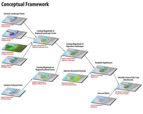
The ILARIS© model was developed to rapidly assess and communicate the intrinsic characteristic landscape forms that define a region’s scenic character, assess the scenic value and cultural heritage of a region, and capture which of these features are most prized by the public.
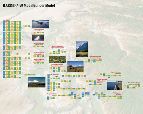
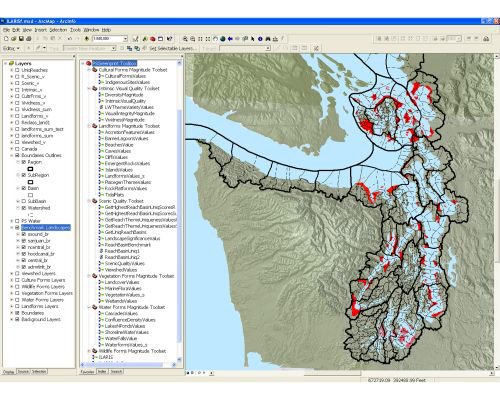
ILARIS© is an ArcGIS ModelBuilder model that consists of 40 sub-models and 3 Python scripts, with over 60 input data layers. All of the sub-models area responsible for capturing the presence, quantity, and size of different intrinsic landscape forms, for measuring the visual diversity, visual integrity, and intrinsic aesthetic quality, as well as the effect of the viewshed, and the relative uniqueness of these signature landscape features in each reach basin analysis unit. Also, the entire model is designed to facilitate the capture of public opinion on the value of these landscape features.
The ILARIS© model allows for rapid assessment because the analysis methodology is built into the modeling process, leaving only two aspects that need to be completed: 1) the spatial framework of regions, subregions, watersheds, sub-watersheds, and basins that contain the landscape forms and 2) the catalog of landscape forms.
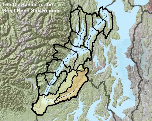
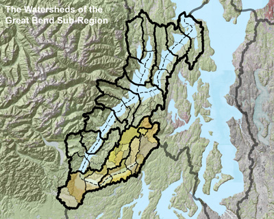
The spatial framework is defined by the regime of systemic hydrographic units of any landscape. Using ArcHydro, a GIS-based hydrology and watershed model developed at the Center for Research in Water Resources at the University of Texas at Austin, very small tessellations (“mosaic tiles”) of watershed catchments are aggregated to form units of minimum distinctive intrinsic character at different levels of scale. Each of these small catchment areas is a fundamental unit ecologically and visually, and in small aggregations constitute each of the basin units in the study area. The boundaries of these basin units are then compared to Omernik’s Ecoregions, Fenneman’s Physiographic Regions, State Watershed Resource Inventory Areas, and to the National Hydrography Dataset’s classification structural boundaries. The purpose of comparing the basin units to these land classification spatial structures is to make sure the basin units can work with and inform these other classification methods. By doing so, results generated by ILARIS© can be integrated to other conservation models that use these national spatial classification structures.
The second task required to implement ILARIS© is to determine which landscape features and forms are to be cataloged. There are five categories of landscape formations that define the intrinsic character of a place, 1) Land Forms (i.e., Mountains, Cliffs, Drumlins), 2) Water Forms (i.e., Lakes, Streams, Oxbow Lakes, Springs), 3) Vegetation Forms (i.e. Madrona Stands, Eelgrass Beds, Pine Forests), 4) Wildlife Forms (i.e. Sea Lion Haulouts, Orca Whale Sightings, Bald Eagle Nests) and, 5) Cultural Forms (i.e. Historic Landmarks, Cultural Landmarks, Indigenous Cultural Landscapes). All five of these categories supply a landscape with the spatial distribution of the landscape formations that are inherent to a region. ILARIS© serves to identify these signature landscapes and calculate the supply and magnitude of intrinsic landscape forms.
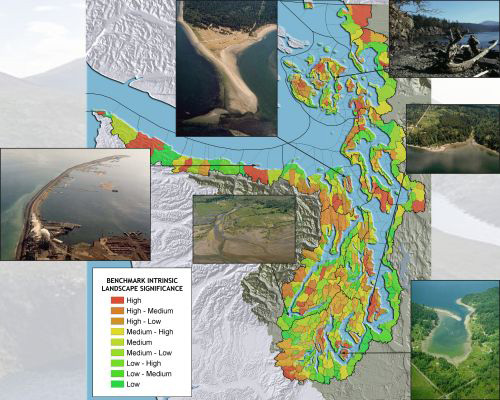
Viewsheds are also an important factor in the methodology behind ILARIS©. The viewshed magnitude of a selected set of forms (such as mountain faces) is calculated to assess which basins can “see” a large number of the intrinsic landscape forms. The supply and magnitude of the landscape formations and the contribution of cumulative viewshed magnitude within a region identifies areas with a high landscape significance value.
The last analysis aspect of ILARIS© is the determination of which intrinsic landscape forms are rare or unique in their sub-regions and regions. To calculate the rarity level, a determination is made as to whether a landscape form is found only in its basin unit. The model identifies which basin units in its region contain a rare instance of that landscape form. The uniqueness values sub model also produces a table recording why a basin unit is considered rare or unique.
Results
Results of initial ILARIS©-based implementations show that once communities better understand the intrinsic character of a place they are more willing to adopt conservation strategies to protect them. Only a few people understand the scientific-based analyses typically used to identify areas to be conserved while most do not. This lack of understanding leads to reluctance and unwillingness to help steward conservation efforts. Since ILARIS© can capture and communicate the voice of the landscape, as well as capture what people value within the landscape, the model can truly facilitate landscape-level conservation plans that protect the intrinsic character of a region.
Conclusions
As our population burgeons, it is imperative that we employ effective and rapid methods to protect our landscape treasures and safeguard ecological, aesthetic, and recreational resources. With ILARIS©, landscape architects can now provide this leadership, better communicate the value of our regional landscapes, and craft visionary and community-based implementable plans that identify the most important places to protect. Landscape architects can help communities understand the character of the local and regional landscape and facilitate stewardship strategies that will engage current and future generations of land stewards.
|