Landscape in Evolution: Creating a Resilient Nomadic Landscape from Bottom up in Hulunbuir
HONOR
Analysis and Planning
Hulunbuir, Inner Mongolia, China | Team: Jingyi Liu, Student Affiliate ASLA; Menghan Zhang, Student Affiliate ASLA; Juelin Zhou, Student Affiliate ASLA; Mingrui Wang, Student Affiliate ASLA; Nating Li, Student Affiliate ASLA; Erji Shang, Student Affiliate ASLA | Faculty Advisor: Qing Lin
Beijing Forestry University
Landscape In Evolution
Creating a Resilient Nomadic Landscape from Bottom up in Hulunbuir
Photo Credit: Jingyi Liu
Media: Please submit high-resolution image requests to images@asla.org.
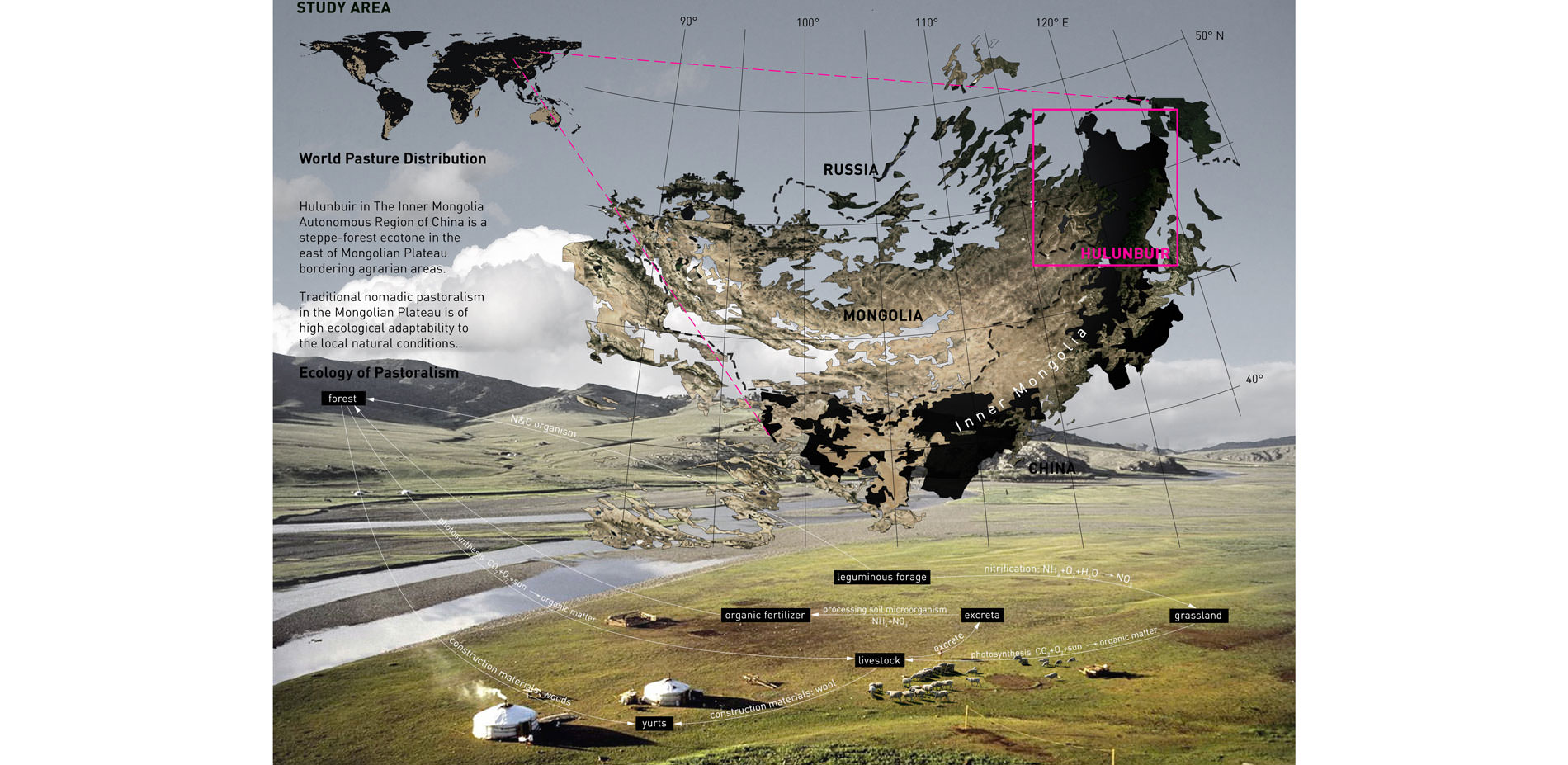
STUDY AREA: World Pasture Distribution
Traditional nomadic pastoralism in the Mongolian Plateu is of high ecological adaptability to the local natural conditions.
Photo Credit: Jingyi Liu
Media: Please submit high-resolution image requests to images@asla.org.
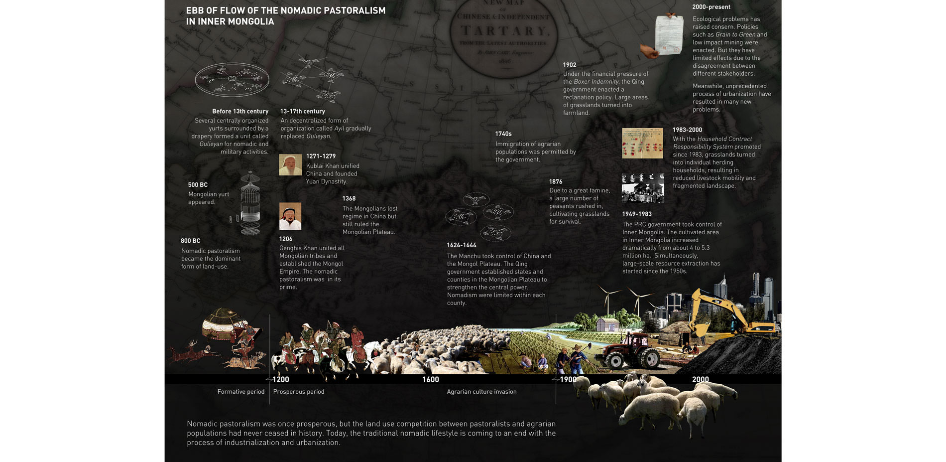
EBB OF Flow of The Nomadic pastoralism in inner Mongolia
Nomadic pastoralism was once prosperous, but the land use competition between pastoralists and agrarian populations had never ceased in history. Today, the traditional nomadic lifestyle is coming to an end with the process of industrialization and urbanization.
Photo Credit: Jingyi Liu
Media: Please submit high-resolution image requests to images@asla.org.
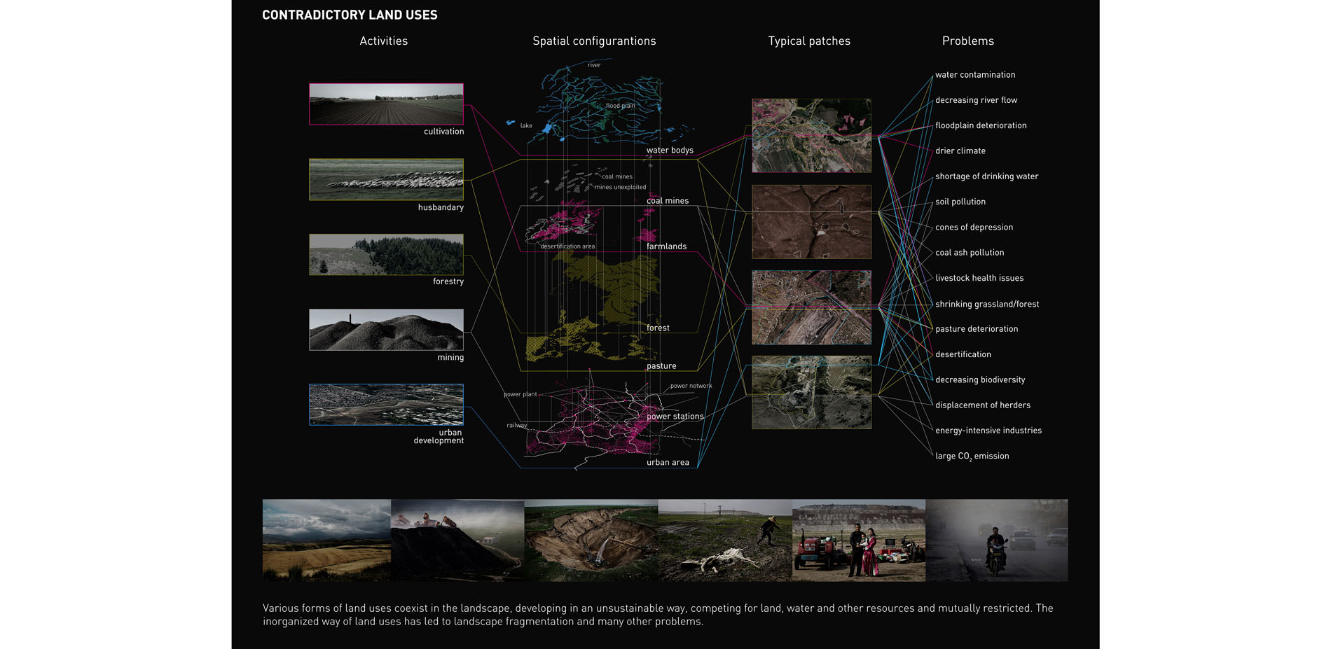
Contradictory Land Uses
Various forms of land uses coexist in the landscape, developing in an unsustainable way, completing for land, water and other resources and mutually restricted. The unorganized way of land uses had led to landscape fragmentation and many other problems.
Photo Credit: Jingyi Liu
Media: Please submit high-resolution image requests to images@asla.org.
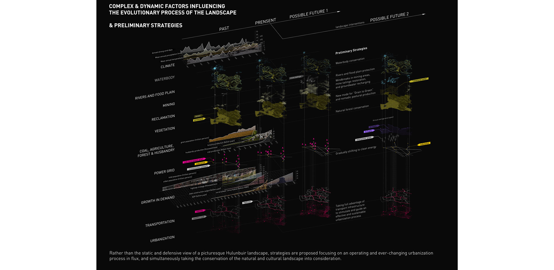
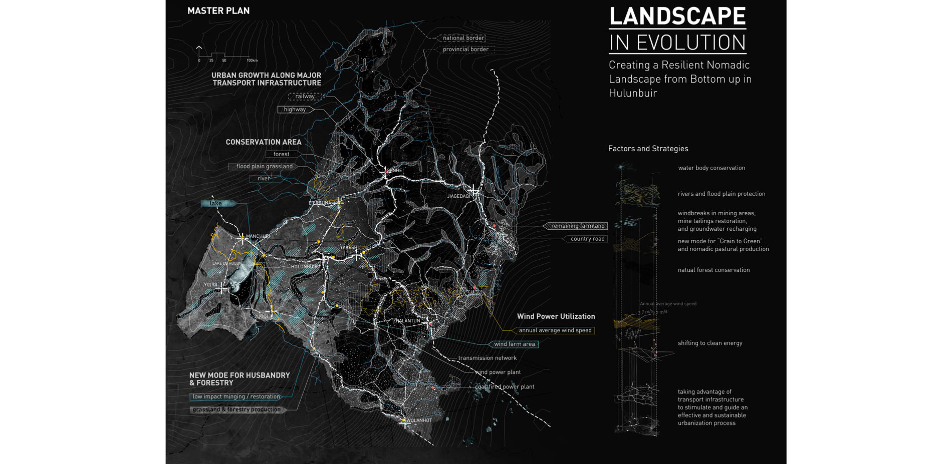
Complex & Dynamic Factors Influencing the evolutionary process of the landscape & preliminary strategies
Rather than the static and defensive view of a picturesque Hulunbuir landscape, strategies are proposed focusing on an operating and ever-changing urbanization process in flux, and simultaneously taking the conversation of the natural and cultural landscape into consideration.
Photo Credit: Jingyi Liu
Media: Please submit high-resolution image requests to images@asla.org.
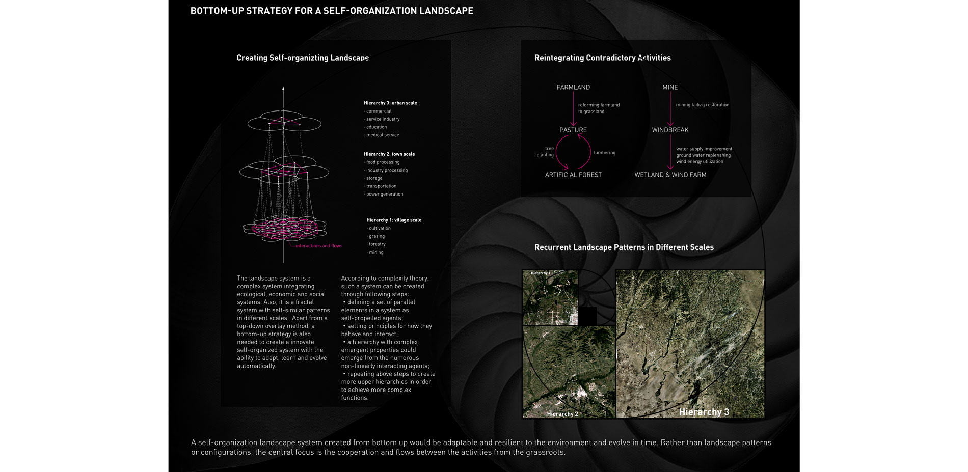
Bottom-up strategy for a self-organization landscape
A self-organization landscape system created from bottom up would be adaptable and resilient to the environment and evolve in time. Rather than landscape patterns or configurations, the central focus is the cooperation and flows between the activities from the grassroots.
Photo Credit: Jingyi Liu
Media: Please submit high-resolution image requests to images@asla.org.
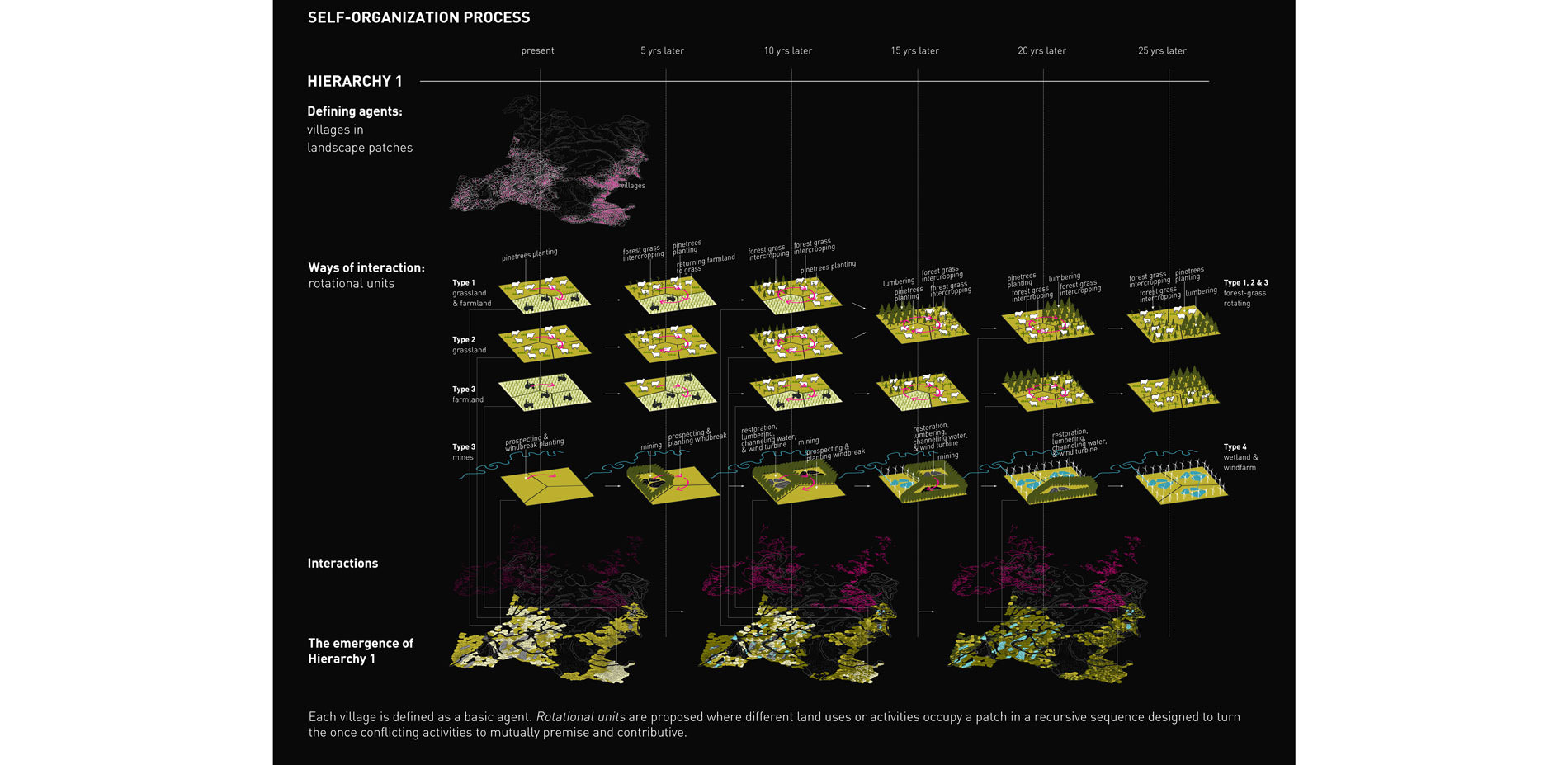
Self-organization process
Each village is defined as a basic agent. Rotational units are proposed where different land uses or activities occupy a patch in a recursive sequence designed to turn the once conflicting activities to mutually premise and contributive.
Photo Credit: Jingyi Liu
Media: Please submit high-resolution image requests to images@asla.org.
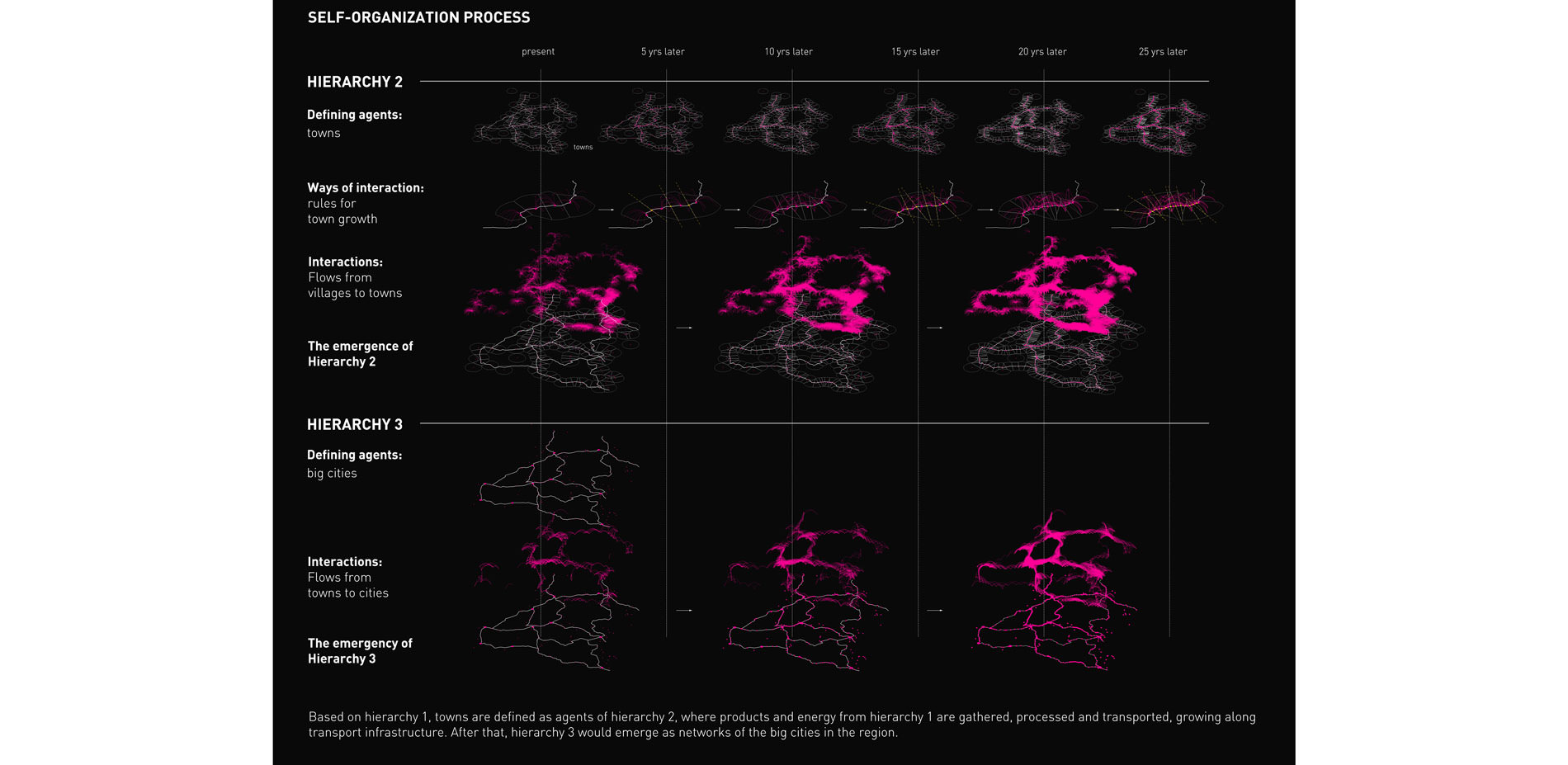
Self-organization process
Based on hierarchy 1, towns are defined as agents of hierarchy 2, where products and energy from hierarchy 1 are gathered, processed and transported, growing along transport infrastructure. After that, hierarchy 3 would emerge as networks of the big cities in the region.
Photo Credit: Jingyi Liu
Media: Please submit high-resolution image requests to images@asla.org.
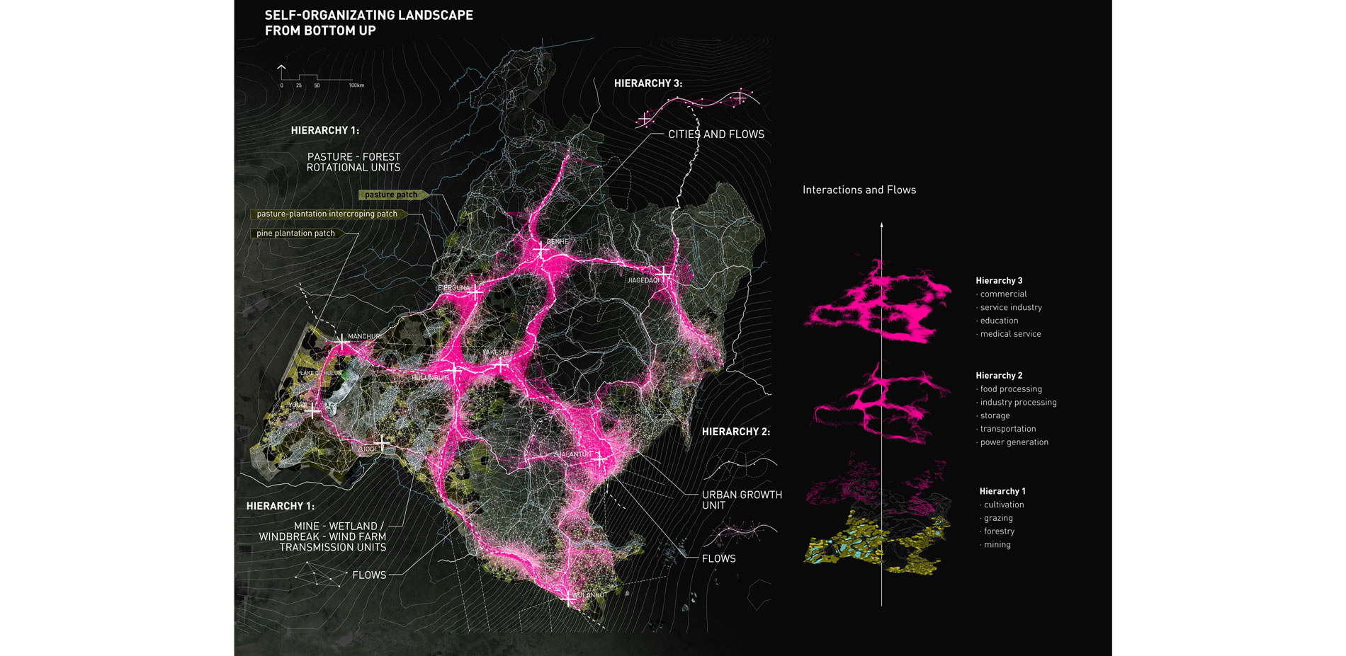
Self-organizating landscape from bottom up
Photo Credit: Jingyi Liu
Media: Please submit high-resolution image requests to images@asla.org.
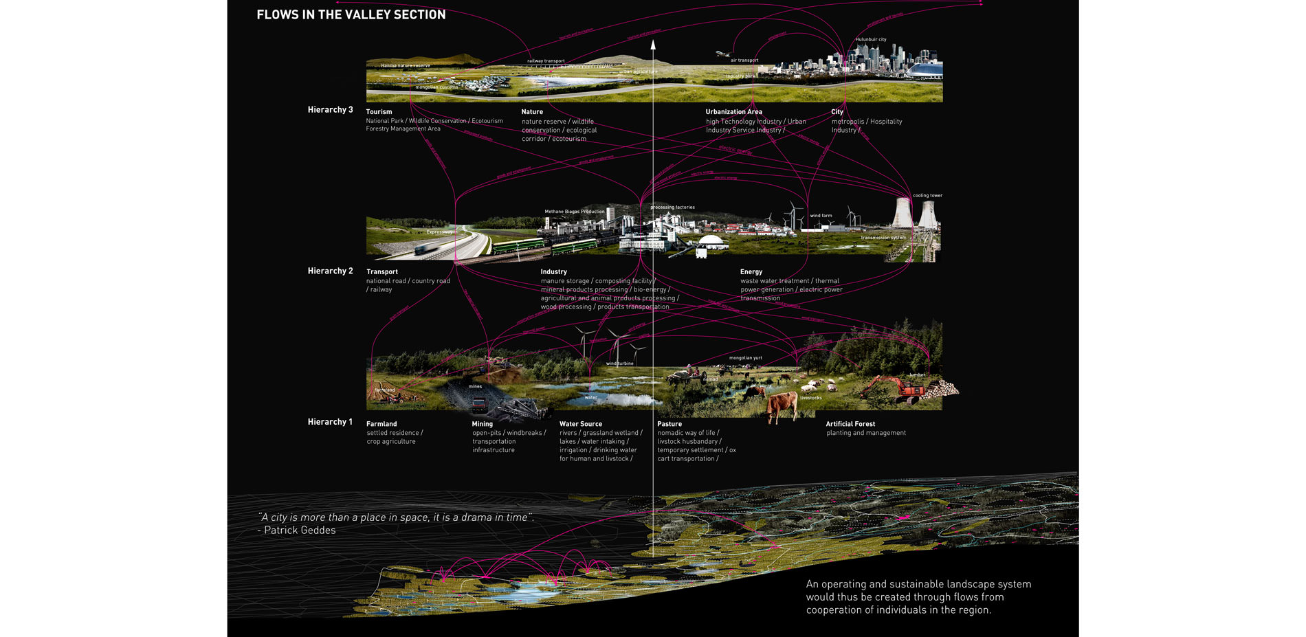
Flows in the valley section
A city is more than a place in space, it is a drama in time - Patrick Geddes
Photo Credit: Jingyi Liu
Media: Please submit high-resolution image requests to images@asla.org.
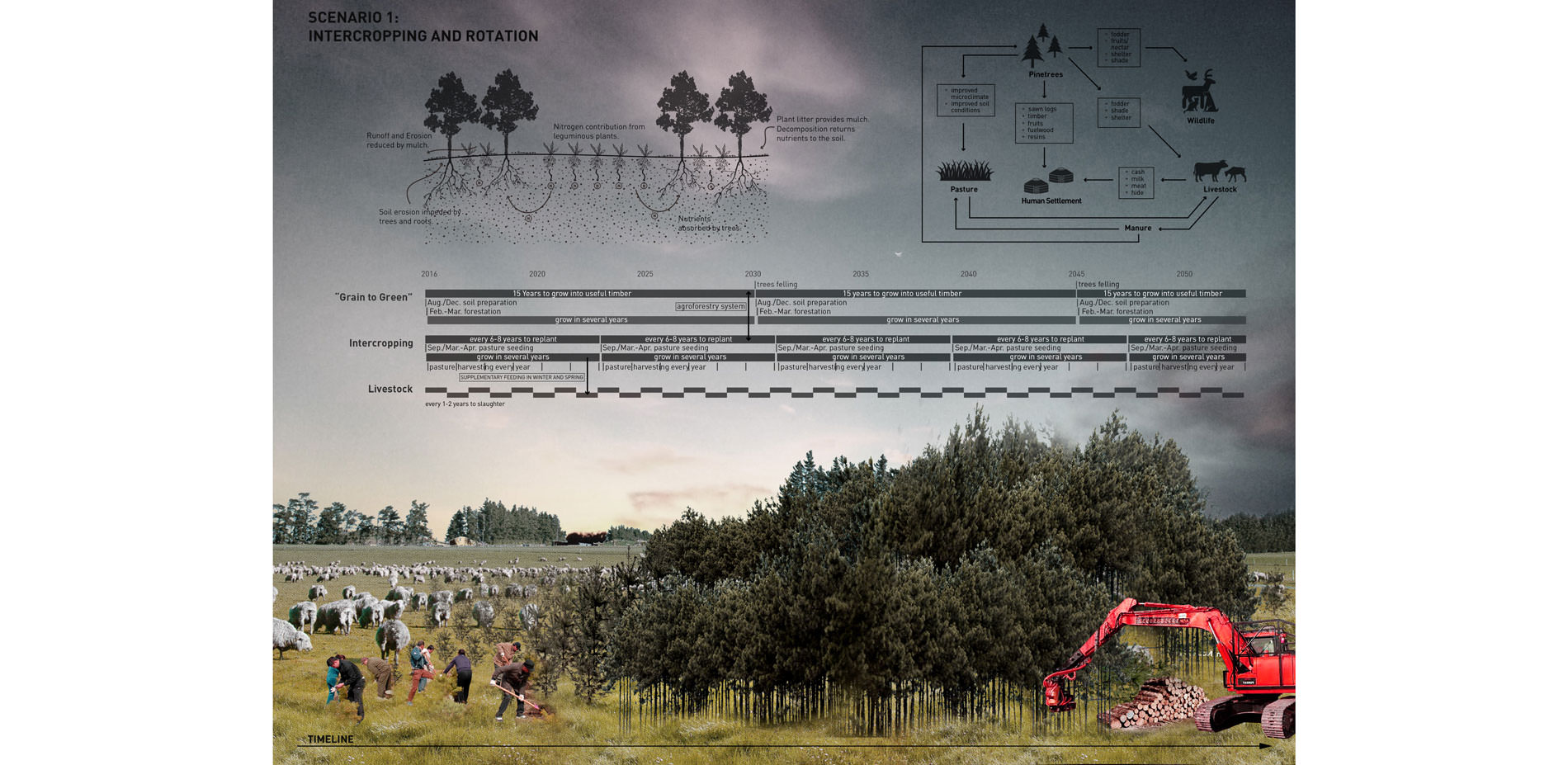
Scenario 1: Intercropping and Rotation
Photo Credit: Jingyi Liu
Media: Please submit high-resolution image requests to images@asla.org.
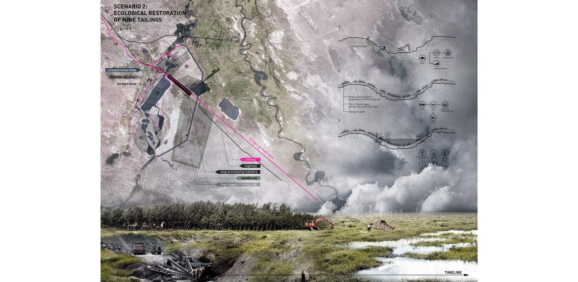
Scenario 2: Ecological Restoration of Mine tailings
Photo Credit: Jingyi Liu
Media: Please submit high-resolution image requests to images@asla.org.
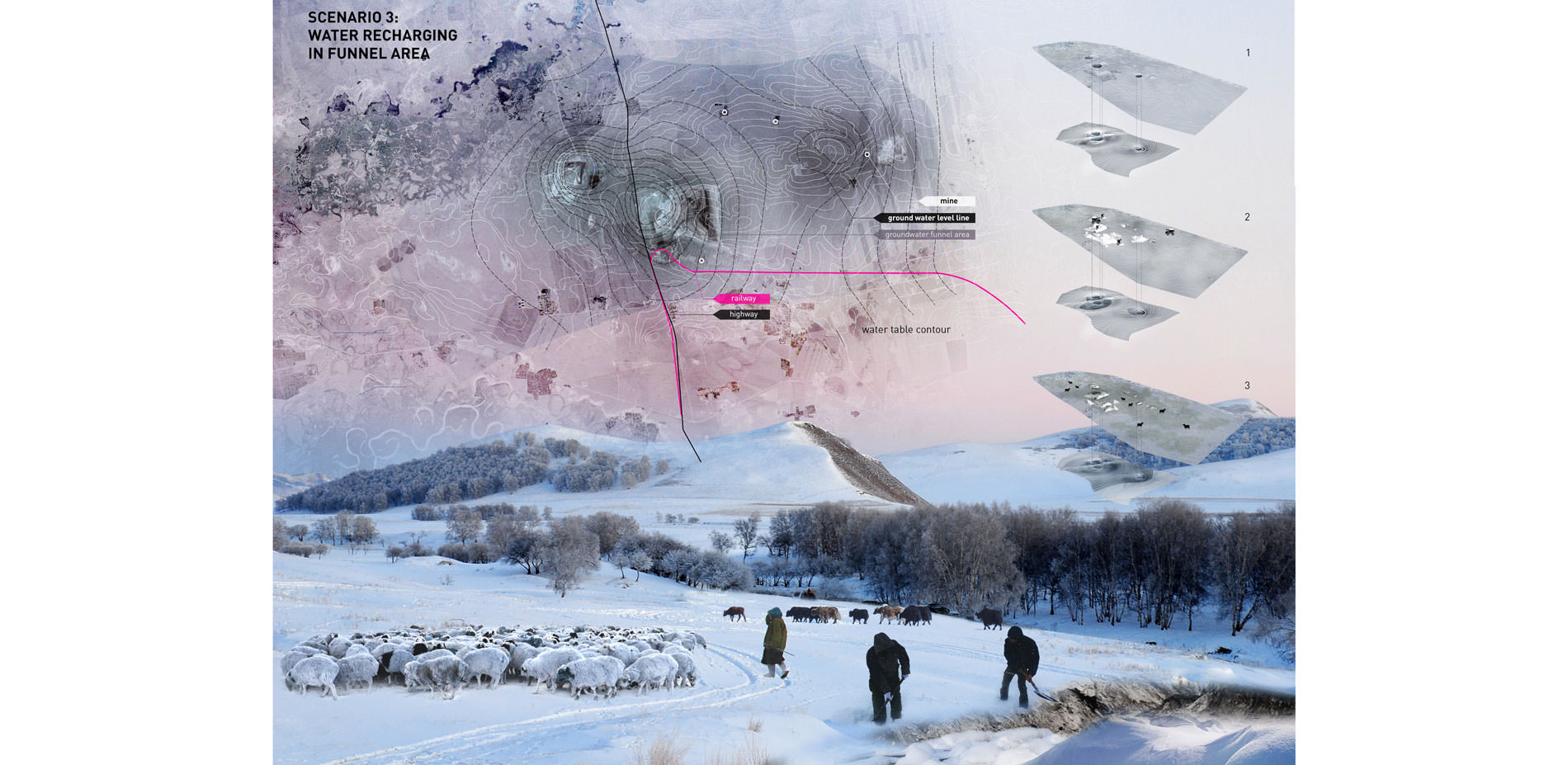
Scenario 3: Water recharging in funnel area
Photo Credit: Jingyi Liu
Media: Please submit high-resolution image requests to images@asla.org.
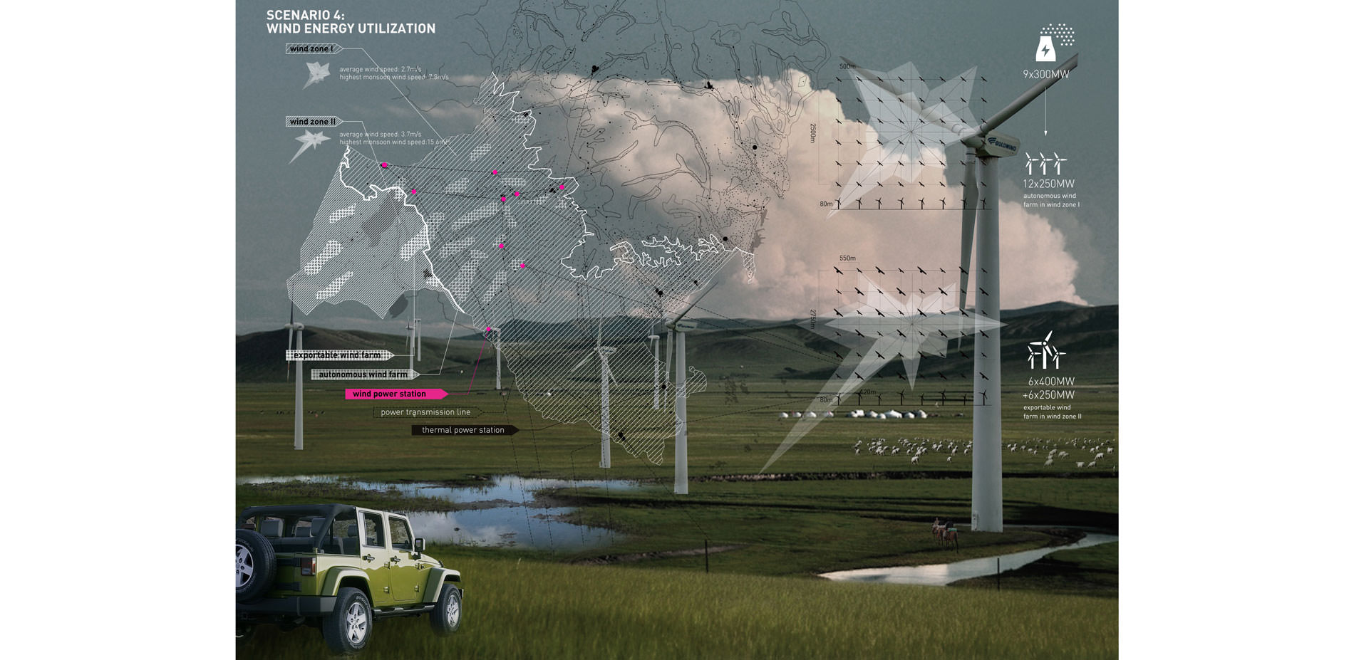
Scenario 4: Wind Energy Utilization
Photo Credit: Jingyi Liu
Media: Please submit high-resolution image requests to images@asla.org.


Economics has typically trumped the culture. This project is a way to address that. It offers a plan for future development that respects the nomadic heritage of the people who live in this landscape.
- 2017 Awards Jury
PROJECT STATEMENT
The study area is in Hulunbuir, Inner Mongolia, China, a region with extremely diversified forms of landscape and land uses. Based on analysis of dynamic and complex factors influencing the evolutionary process of the region, the landscape is considered and created as an agent-based self-organizing system from bottom up, which is resilient and adaptable to the environment and ever-changing in time. Rather than landscape patterns or configurations, the central focus of the design is the cooperation and flows between the activities from the grassroots, such as grazing, forestry, farming, mining, manufacture, energy generating and urban construction. Rotational Units are proposed as the main strategy rearranging the different forms of land uses to occupy particular patches in a recursive sequence in order to make the once conflicting human activities mutually dependent and contributive. Specific approaches are further explored and proposed for grassland restoration, grass-forest intercropping, mine tailings restoration, water supply improvement, groundwater replenishing and wind energy utilization in some envisioned future scenarios.
PROJECT NARRATIVE
An Overview of the Study Area
Known for vast grasslands, the Mongolian Plateau had given birth to a splendid nomadic civilization developed by the Mongolians during their long history. In the south of the Plateau, there had been roughly a dividing line between nomadic pastoralism and cultivation, shifting back and forth in response to climate and political factors. Conflicts between Mongolians and agrarian populations in the south had never ceased in history. In the 1940s, the Mongolian Plateau was divided into two main parts: the independent State of Mongolia in the north and the Inner Mongolia Autonomous Region of China (Inner Mongolia for short) in the south. Affiliated to the government of the agrarian nation, Inner Mongolia had lost large areas of grasslands due to the belief of “agrarian first”. The government was hostile to pastoralists and forced them to settle down in villages, counties and towns. In the meantime, Inner Mongolia was found to be a resource-rich region, and large-scale resource extraction activities have begun since the 1950s. Nowadays, Landscape fragmentation and ecology deterioration has brought about severe problems in Inner Mongolia. However, land development and industrial diversity, on the other hand, have given rise to economic prosperity and accelerated urbanization process.
Hulunbuir is a steppe-forest ecotone in the northeast of Inner Mongolia. Due to the unique natural environment and nomadic culture, highly dynamic land-use have been an inherent and distinguishing characteristic of this area. However, the traditional nomadic lifestyle is coming to an end with the process of modernization. In addition, this region is currently experiencing an unprecedented urbanization process with the area of cities and towns being about eight times of what it was in 1985. Various forms of land uses coexist in the landscape, mainly including cultivation, grazing, forestry, coal mining and urban construction. Most of them are developing in an unsustainable way, competing for land, water and other resources and mutually restricted. The inorganized way of land uses has led to landscape fragmentation and many other problems.
The increasingly severe problems have raised concern and a series of policies were made by the government since the turn of the century, including Grain to Green (to reform the farmland into forest/grassland), ecological restoration and low impact mining. However, these policies have had limited effects due to lack of mechanisms to coordinate the interests of all parties.
Analysis of complex and dynamic layers
"The artist does not illustrate science; … he frequently responds to the same interests that scientist does, and expresses by a visual synthesis what the scientist converts into analytical formulae or experimental demonstrations."
-- Lewis Mumford, “The Arts,” in Whither Mankind: Panorama of Modern Civilization (1928, p. 296)
Rather than the static and defensive view of a picturesque Hulunbuir landscape, this design focuses on an operating and ever-changing process of the landscape system, and simultaneously taking the conservation of the natural and cultural landscape into consideration. Various dynamic layers are influencing the complex system of the landscape and urbanization, including:
- the unsettled climate;
- the shrinking of water bodies
- the shrinking of forestry and livestock husbandry with the expansion of farmland;
- the increase of highway and the once busy but recently declining railway;
- the prosperous but unsustainable coal industry;
- the once attractive but recently declining grassland tourism destination;
- the ever-growing population, economy, construction and consumption, etc.
Through the analysis of the layers, some preliminary strategies were proposed as follows:
- conserving and restoring water bodies, flood plain, natural forest and existing nature reserves;
- implementing new modes for each separated activity and land use, making them mutually connected and contributive;
- gradually reducing the dependence on coal energy and shifting to clean energy;
- taking full advantage of the transport infrastructure to stimulate industrial agglomeration and guiding an effective and sustainable urbanization process.
Creating a Self-Organization System from Bottom up
"A city is more than a place in space, it is a drama in time."
-- Patrick Geddes, Civic: as Applied Sociology (1905, p. 6)
As the landscape is a complex system in evolution, a master plan alone through top-down analytic derivation would be insufficient. Bottom-up strategies are thence proposed in order to create a self-organization system by spontaneous cooperation from the grassroots -- the mutually interconnected land uses and activities. Such a landscape system would be highly adaptable and resilient to the unsettled environment and evolve in time.
According to the most up-to-date landscape and urban modeling theories which assume complex adaptive systems should consist of many autonomous agents and recurrent patterns in different scales, such systems can be created by taking following steps:
- defining a set of parallel elements in a system as self-propelled agents;
- setting principles for how they behave and interact;
- a hierarchy with complex emergent properties could emerge from the numerous non-linearly interacting agents;
- more upper hierarchies can be created in the same way repeating the above steps to achieve more complex properties.
As for our design, the central focus is the cooperation and flows between the activities from the grassroots, such as nomadic pastoralism, forestry, farming, mining, manufacture, energy generating and urban construction, so each village in a particular patch with a main form of land use is defined as a basic agent. Rotational Units are proposed rearranging the different forms of land uses to occupy particular patches in a recursive sequence in order to make the once conflicting activities mutually dependent and contributive, so that the multiple processes in the landscape would be effective and sustainable. Farmlands, pastures and plantations are designed to interact in a Rotational Unit integrating the Grain to Green, pastoral nomadism and forestry development. Likewise, mines, wetlands, windbreaks and wind farms could interact integrating mining, mine tailings restoration, water supply improvement, groundwater replenishing and wind energy utilization. These interrelated activities would emerge as a bottom hierarchy (hierarchy 1) in the system.
Based on hierarchy 1 would be the urbanization process. Towns are defined as agents of hierarchy 2, where products and energy from hierarchy 1 are gathered, processed and transported, growing along transport infrastructure. After that, hierarchy 3 would emerge as a network of cities in the region.