Reviving the 30 Meters
HONOR
Analysis and Planning
Yunyang City, China | Tianjiao Yan, Student ASLA | Faculty Advisor: Justine Holzman, ASLA
University of Toronto
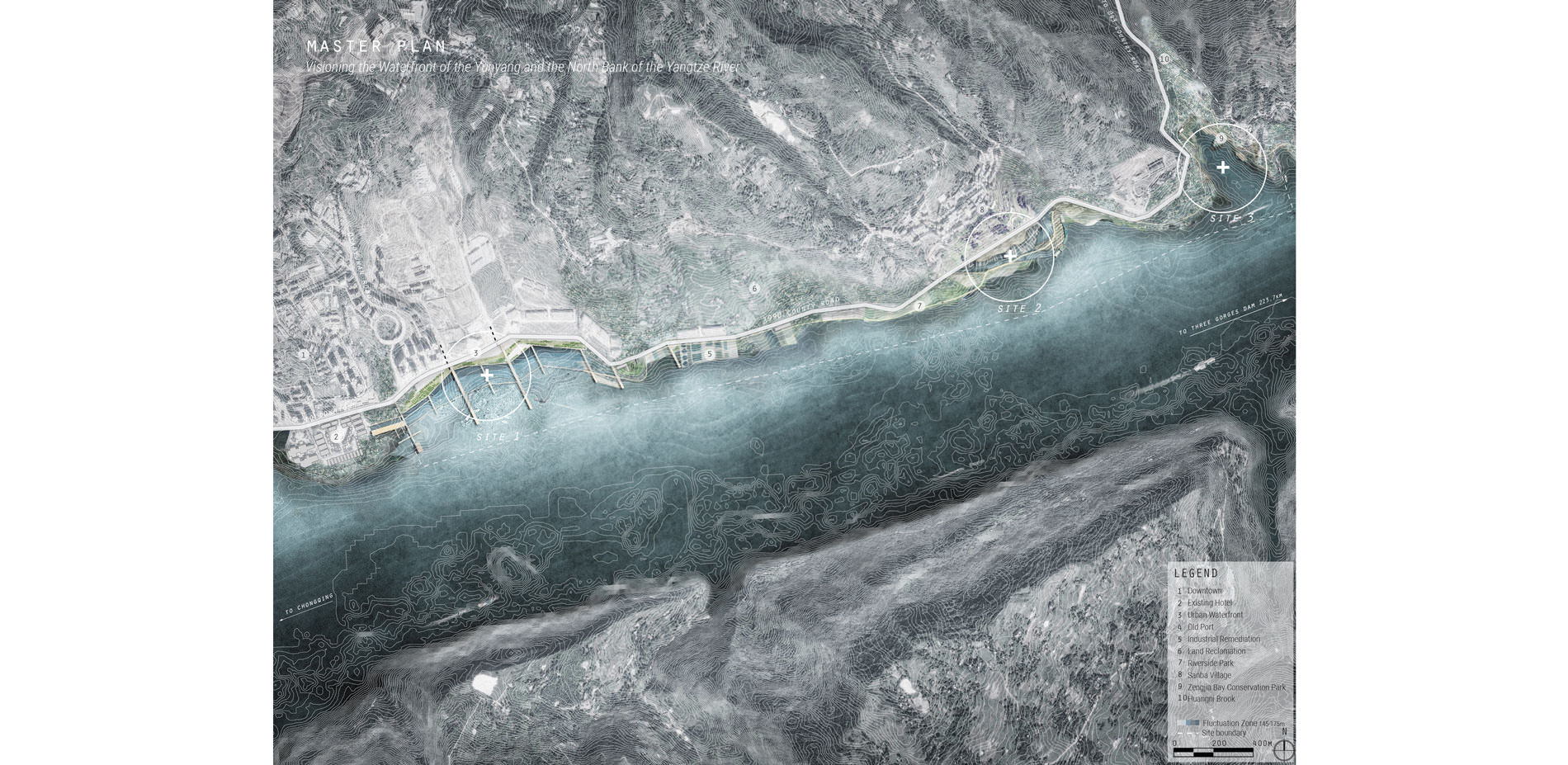
Master Plan
Visioning the Waterfront of The Yunyang and the North Bank of Yantze River
Photo Credit: Tianjiao Yan
Media: Please submit high-resolution image requests to images@asla.org.
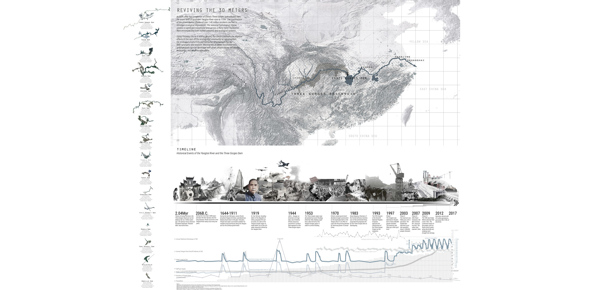
The Location and Timeline Analysis
Reviving the 30 Meters: Site location, history timelines of the Three Gorges Dam, and a collection of world's largest dams.
Photo Credit: Tianjiao Yan
Media: Please submit high-resolution image requests to images@asla.org.
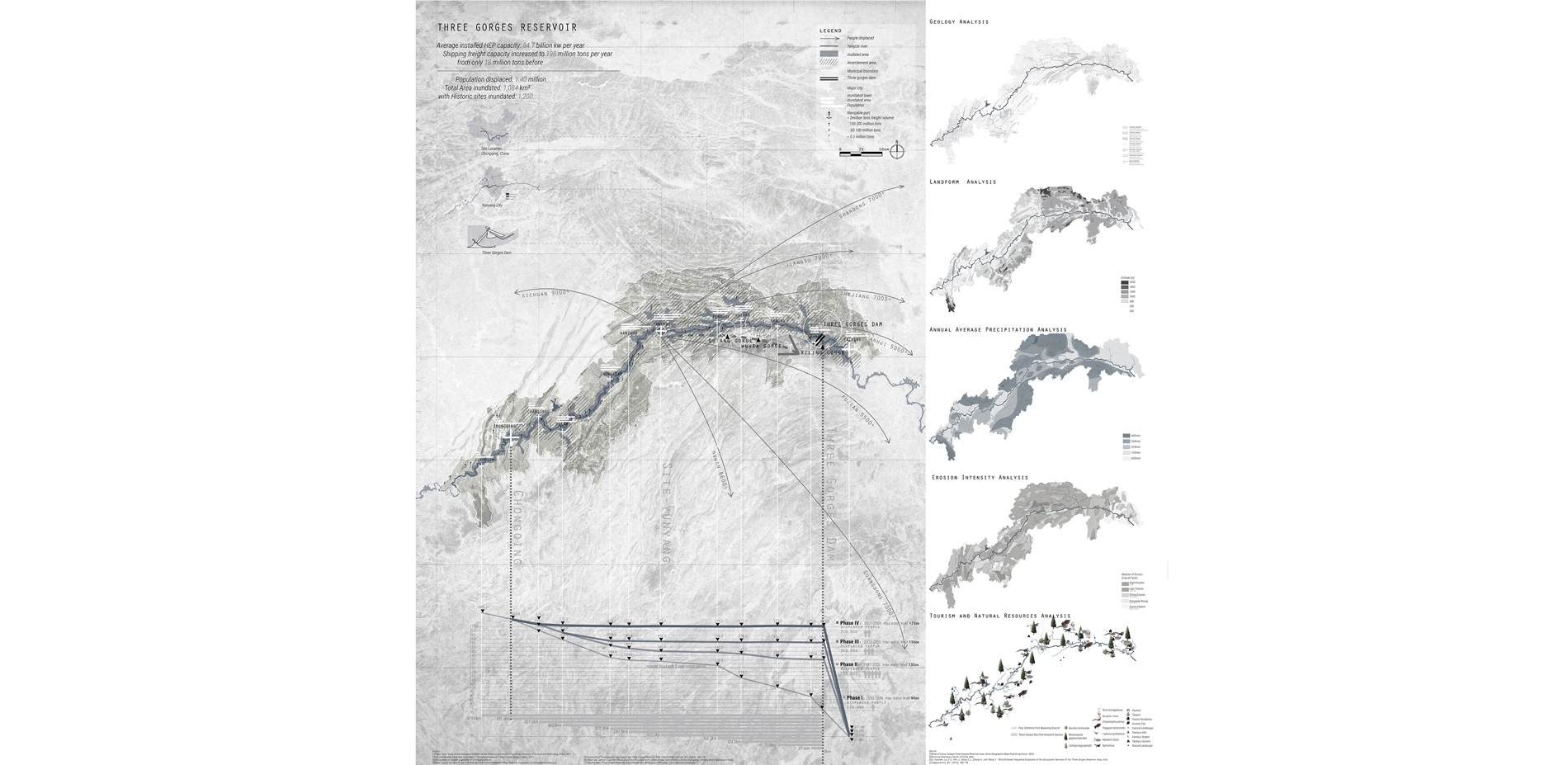
Regional Analysis of the Three Gorges Reservior
The mapping of inundation, resettlement, impoundment process, geology, and natural resources.
Photo Credit: Tianjiao Yan
Media: Please submit high-resolution image requests to images@asla.org.
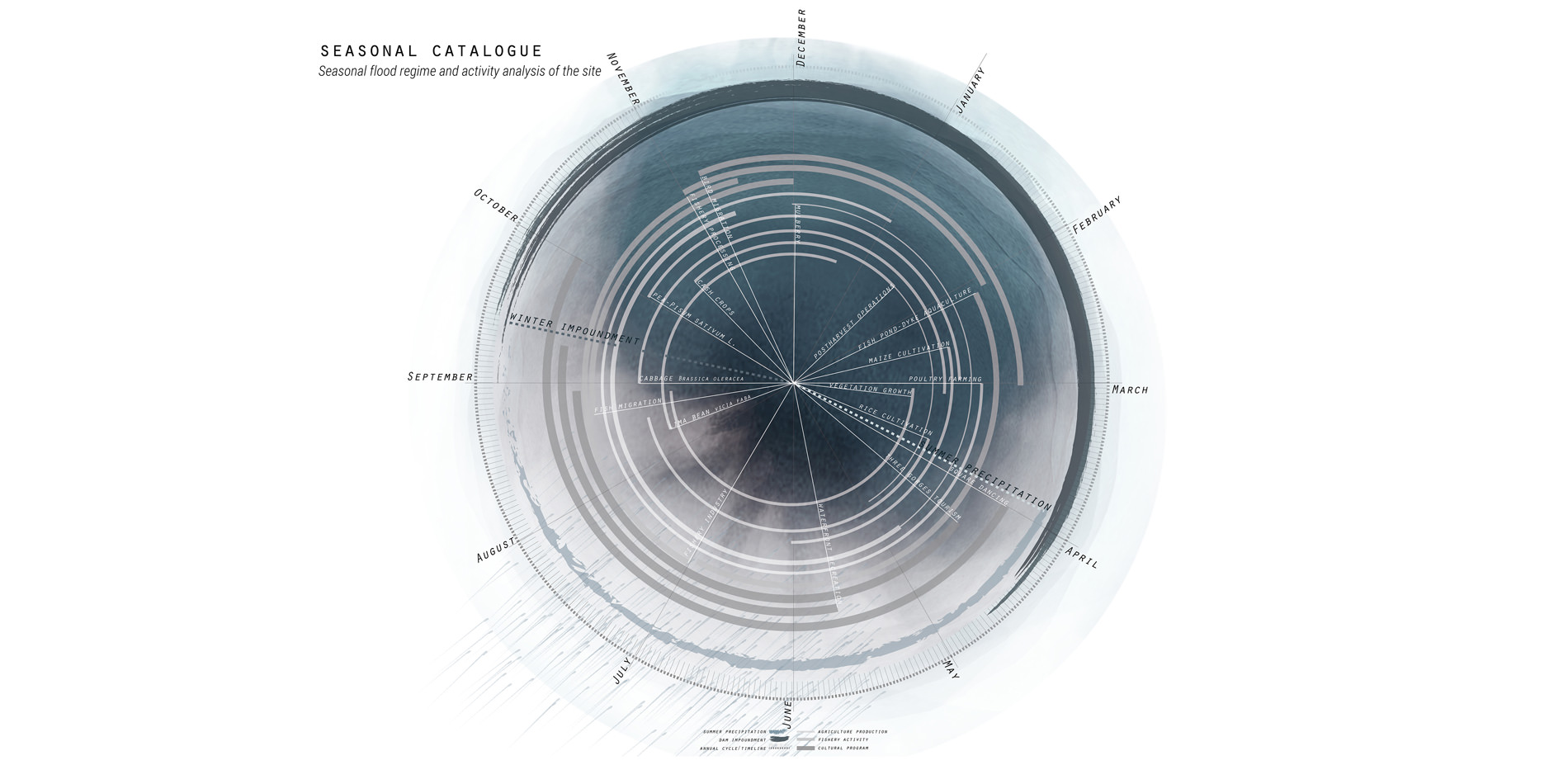
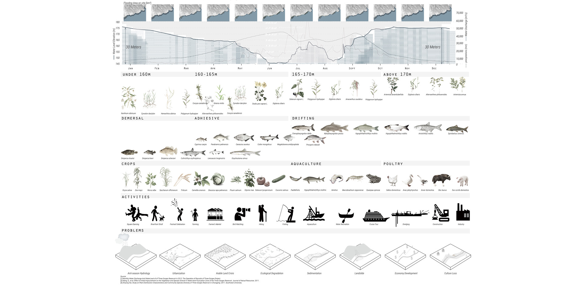
Seasonal Catalogue
The relationship between seasonal flood, precipitation and program schedules of the site
Photo Credit: Tianjiao Yan
Media: Please submit high-resolution image requests to images@asla.org.
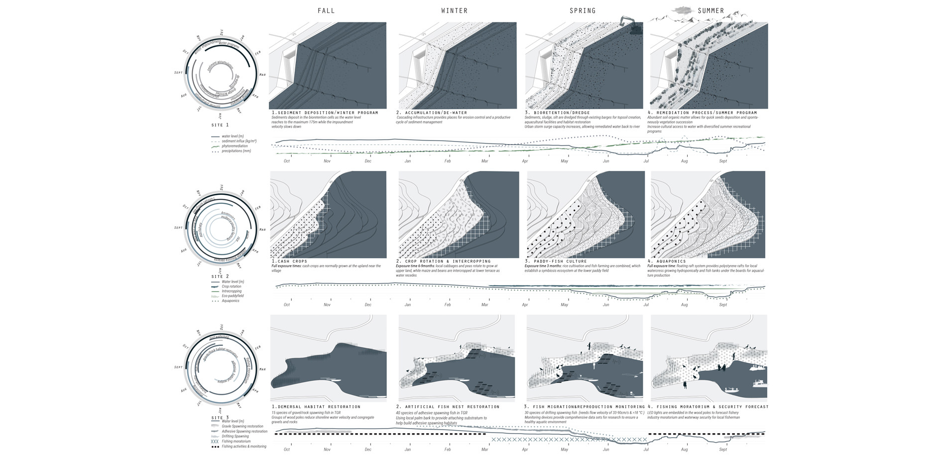
Annual Hydrologic Cycle and Ecological/Human Activity Analysis
Photo Credit: Tianjiao Yan
Media: Please submit high-resolution image requests to images@asla.org.
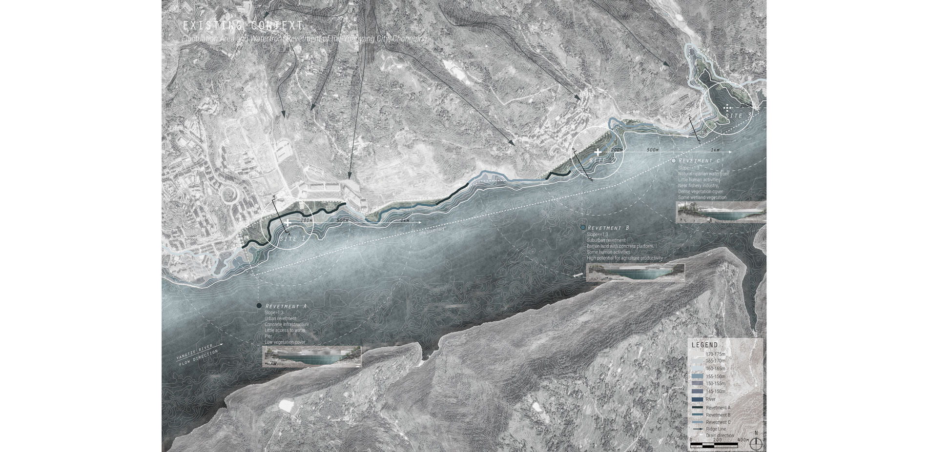
Existing Context:
Thirty-meter seasonal fluctation zone and the changing waterfront revetments
Photo Credit: Tianjiao Yan
Media: Please submit high-resolution image requests to images@asla.org.
Phasing:
Catalyzing the anthropogenic seasonal hydrological regime into cultural, ecological, and economic opportunities
Photo Credit: Tianjiao Yan
Media: Please submit high-resolution image requests to images@asla.org.
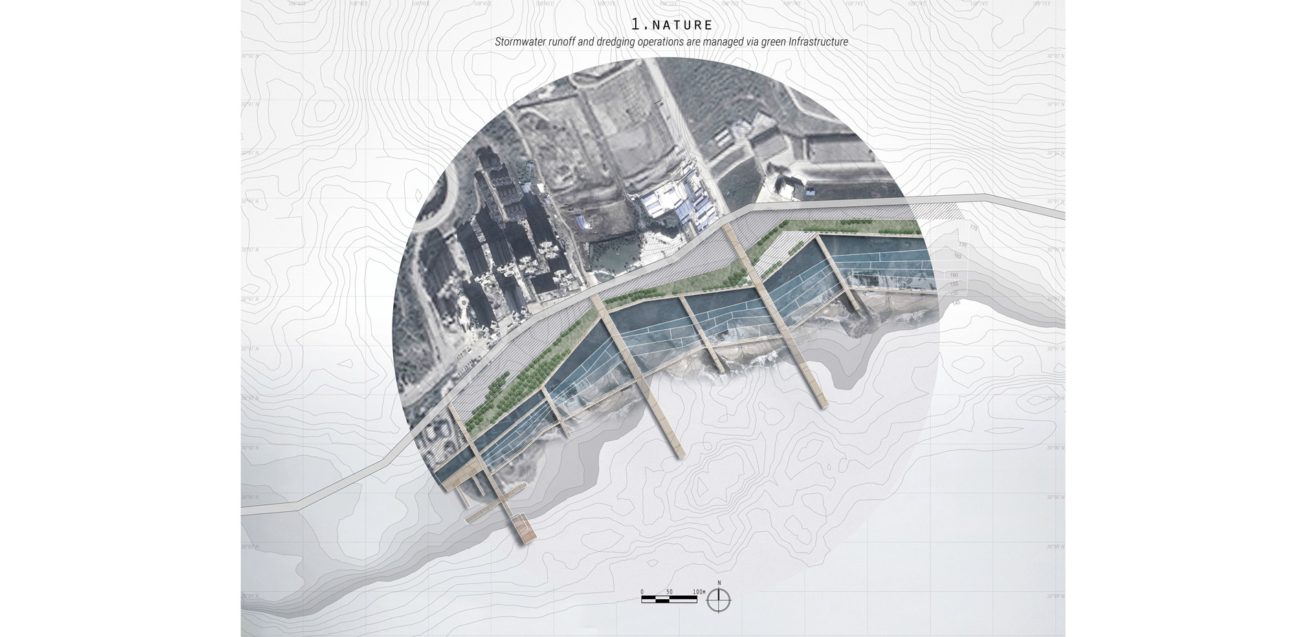
Site 1. Nature: Stormwater Runoff and Dredging Operations are Managed Via Green Infrastructure
Photo Credit: Tianjiao Yan
Media: Please submit high-resolution image requests to images@asla.org.
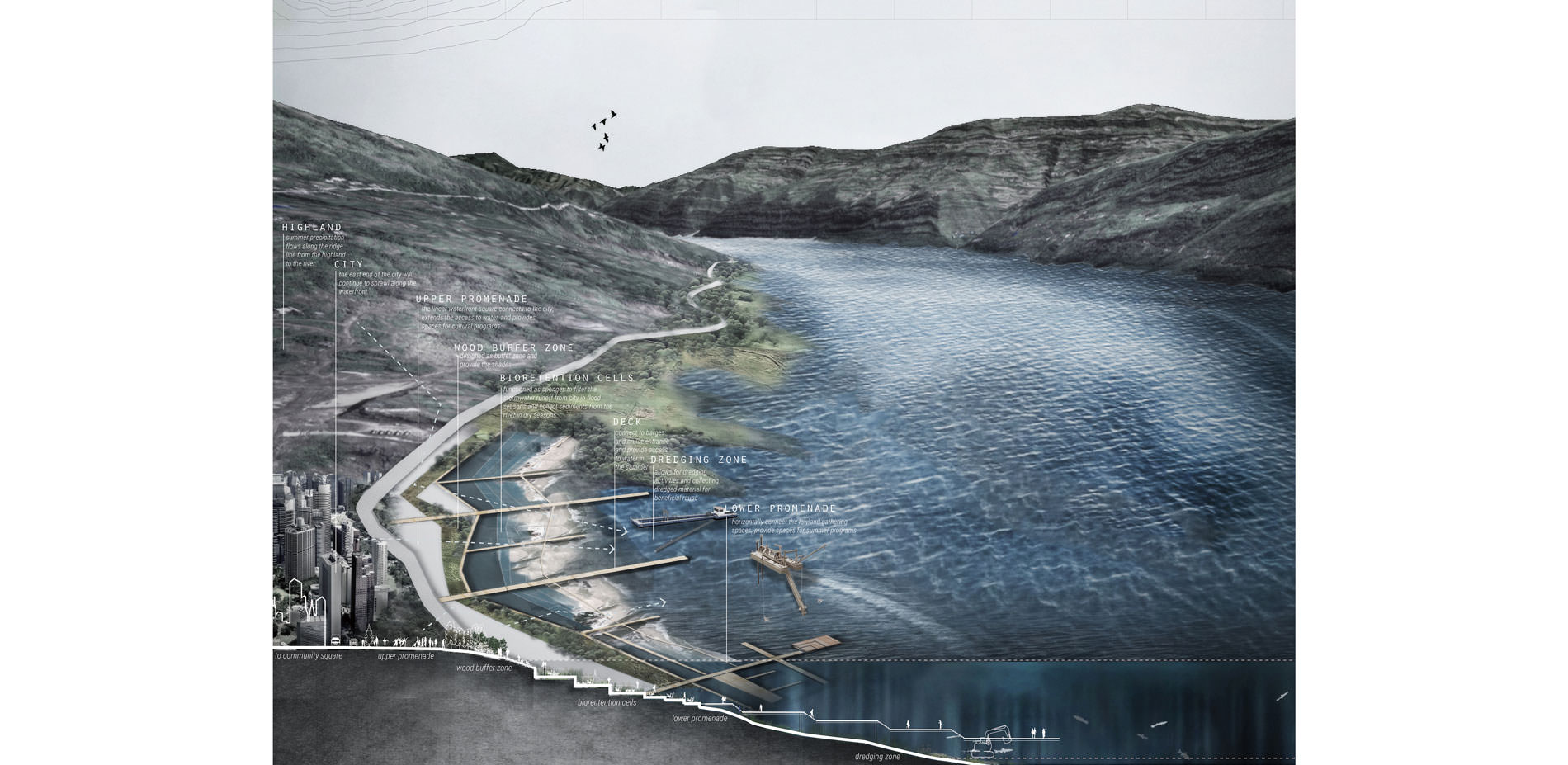
Site 1
Sectional perspective of the waterfront from the city
Photo Credit: Tianjiao Yan
Media: Please submit high-resolution image requests to images@asla.org.
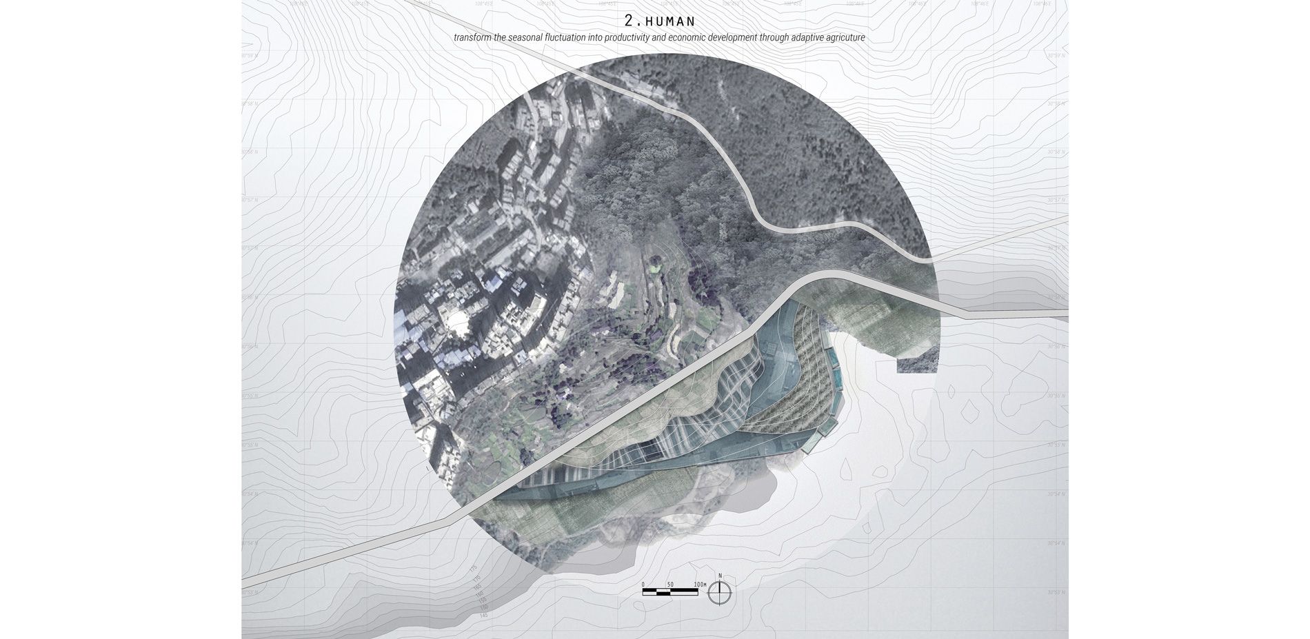
Site 2. Human:
Transform the Seasonal Fluctuation into Productivity and Economic Development Through Adaptive Agriculture
Photo Credit: Tianjiao Yan
Media: Please submit high-resolution image requests to images@asla.org.
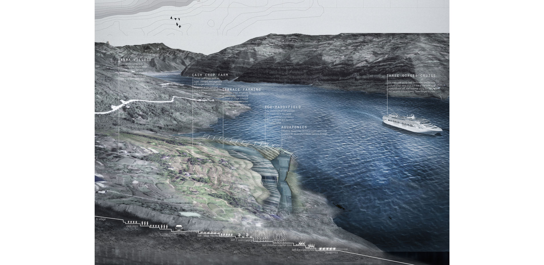
Site 2:
Sectional perspective of the terrace from the nearby Sanba Village
Photo Credit: Tianjiao Yan
Media: Please submit high-resolution image requests to images@asla.org.
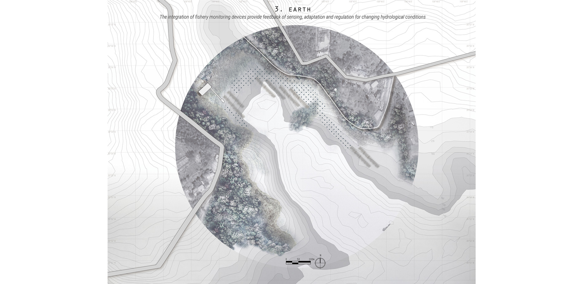
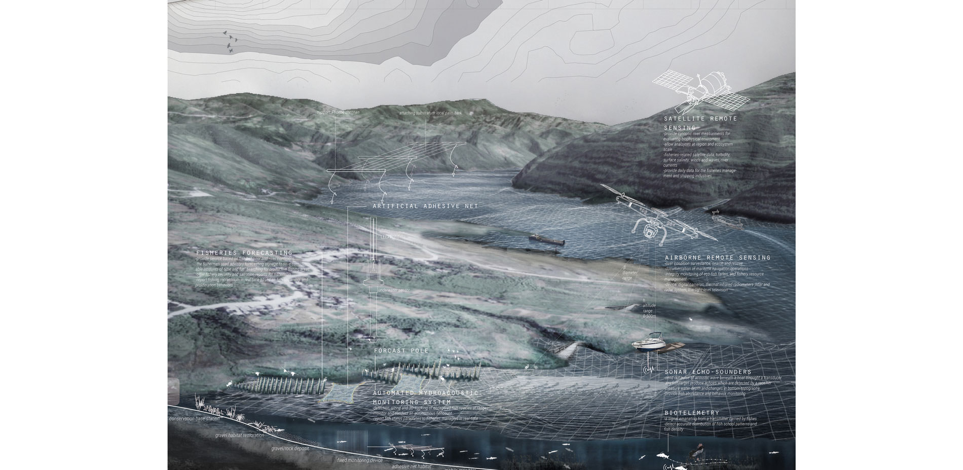
Site 3. Earth:
The Integration of Fishery Monitoring Devices Provides Feedback of Sensing, Adaptation and Regulation for Changing Hydrological conditions, and restore resilient aquatic habitats for endangered species in Yangtze River
Photo Credit: Tianjiao Yan
Media: Please submit high-resolution image requests to images@asla.org.
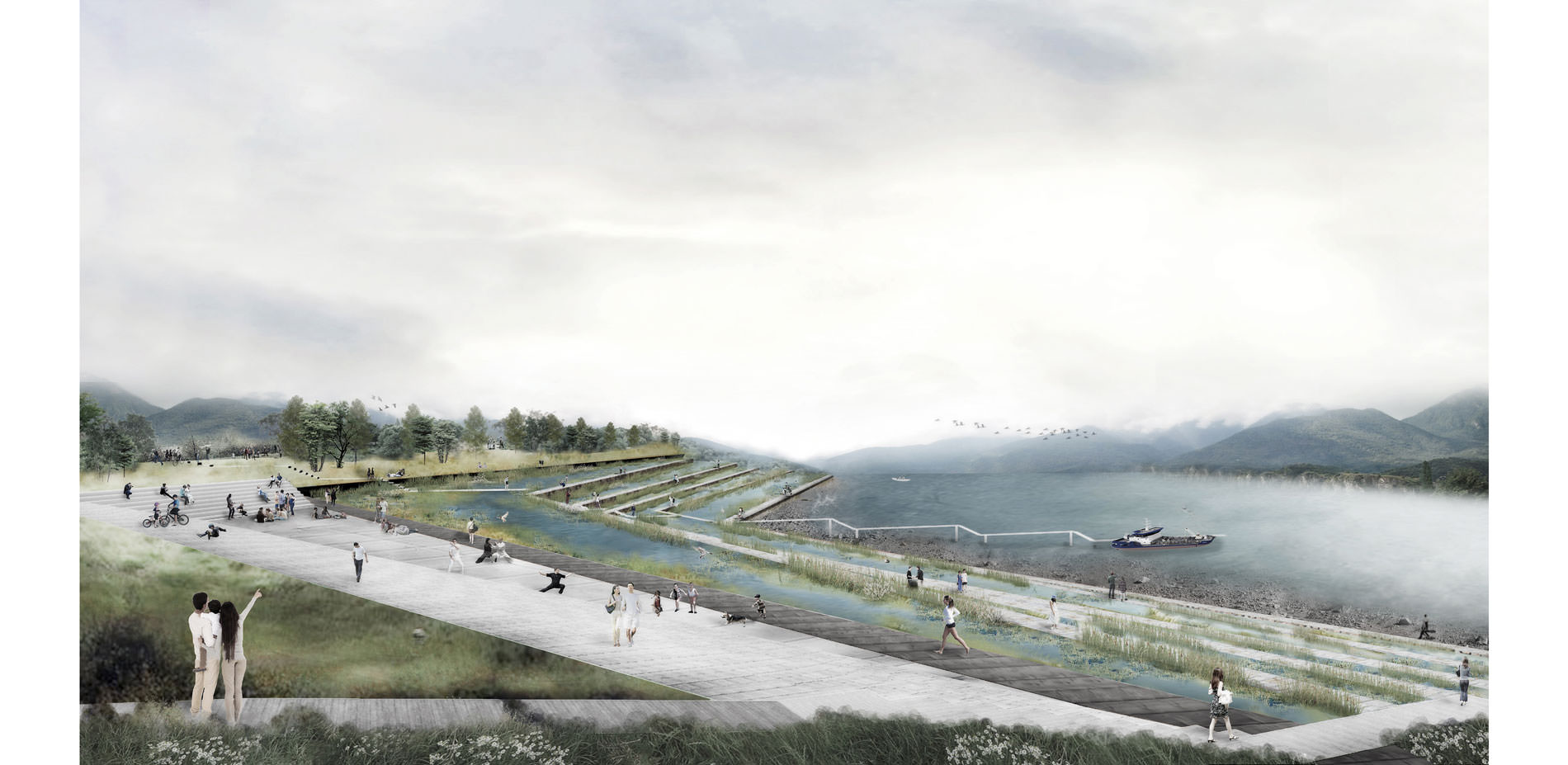
Site 3:
Sectional perspective of the fishery bay with the integrated monitoring system
Photo Credit: Tianjiao Yan
Media: Please submit high-resolution image requests to images@asla.org.
View from the city's waterfront towards the Yangtze River in summer
Photo Credit: Tianjiao Yan
Media: Please submit high-resolution image requests to images@asla.org.
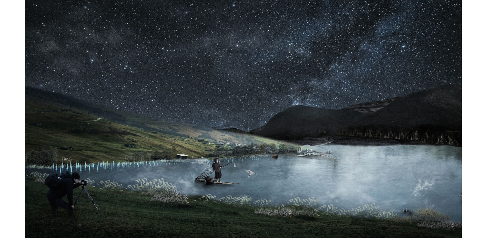
Night view from Lulin fishery bay towards the Yangtze River in fall
Photo Credit: Tianjiao Yan
Media: Please submit high-resolution image requests to images@asla.org.


A really strong project from analysis level through the planning down to site-specific proposals.
- 2017 Awards Jury
PROJECT CREDITS
- Dai Zhijun, et al. Detection of the Three Gorges Dam influence on the Changjiang (Yangtze River) submerged delta. Nature.
- Embassy of the People’s Republic of China in the United States of America. Chronology of Three Gorges Project.
- Li Yuechen, et al. RS/GIS-based integrated Evaluation of the ecosystem services of the Three Gorges Reservoir area, Acta Ecologica Sinica. 33.1 (2013): 168-178.
- Liang Fuqin. Study on the Immigrant Problem of the Three Gorges Project. Huazhong University of Science and Technology Press, 2011.
- Lin Qiusheng, Huang Li. Analysis on the Change of Water and Sediment in the Mainstream of the Yangtze River. 2011.
- Mao Hanying. Three Gorges Reservoir Area Immigration: World Class Difficulties. China National Geography.
- State Council Georges Project Construction Committee Executive Office. Scientific preparation of resettlement planning.
- Walker Jake, Dailey Alison. Save Chaotianmen. John Daniels faculty of Architecture, Landscape, and Design. 2014.
- Wang, Q., et al. Effect of Initial Impoundment on the Vegetation and Species Diversity in Water-level Fluctuation Zone of the Three Gorges Reservoir. JOURNAL OF NATURAL RESOURCES. 2011.
- Xia Zhiyong. Study on Plant Distribution Characteristics and Community Species Diversity of Three Gorges Reservoir in Chongqing. 2011. Southwest University.
PROJECT STATEMENT
In 2010, after the completion of China’s Three Gorges Dam, the water level of upstream Yangtze River rose to 175 meters. The construction of the hydroelectric station has displaced over 1.24 million residents and led to immense ecological degradation. The seasonal hydrological regime creates a significant transitional area across a thirty-meter fluctuation from encompassing both human activities and ecological systems.
Using Yunyang City as a testing ground, this project confronts the negative effects of the hydroelectric dam on the ecology and community as opportunities for ecological productivity and economic development that are both synergetic and resilient. Reviving the 30 Meters transforms this anthropogenic riparian landscape with green infrastructure, monitoring technology, and adaptive agriculture.
PROJECT NARRATIVE
BACKGROUND
As one of the world’s largest hydroelectric dam, the Three Gorges Dam is spanning the midstream Yangtze River in China. After decades of construction, the dam had raised the water level of upstream Yangtze River to 175 meters above sea level by October 2010, forming a large linear river reservoir. The large-scale water regulation has brought numerous benefits such as the creation of loads of electricity, protection for millions of people from floods, and the improvement of the navigability of the Yangtze River.
However, it had profound implications for the integrity of ecosystems and human activities. During the water impoundment process, a 632 km2 of riparian lands were flooded, with 13 cities, 140 towns, and 1,352 villages submerged in the water. Over 1.24 million people were relocated to new settlements built on the higher ground or displaced to other provinces.
The Three Gorges Reservoir are currently controlled under a seasonal flow regime, resulting in a thirty-meter riparian fluctuation zone. In a typical annual cycle, there are four water dispatch modes:
(i) Pre-discharge dispatch: the water is released in May-June to prepare for the summer flood control
(ii) Flood-control dispatch: the water level recedes to the minimum 145 meters for flood control
(iii) Water-storage dispatch: water impounding in September-October to prepare for electricity generation
(iv) Water-supplement dispatch: water is released in January-March from the maximum water level of 175 meters
The seasonal flow regime has created a thirty-meter fluctuation zone (approximately 440 km2 of riparian lands) in the Three Gorges Reservoir. Reviving this distinctive riparian landscape becomes imperative because it is not only the interface of terrestrial and aquatic ecosystems but also the cradle of Three Gorges civilization.
ISSUES
1) Ecosystem degradation
The dramatic hydrologic changes have greatly increased the vulnerability and sensitivity of the ecosystems. Due to the seasonal flow regime, the thirty-meter fluctuation zone is alternately controlled by terrestrial and aquatic ecosystems.The unstable riparian habitats make terrestrial species difficult to adapt the changing environments. Also, habitat degradation has profound impactions on the stability of the aquatic species. Among the 1,085 aquatic species in the Three Gorges Reservoir, 361 freshwater fish species are especially affected due to the changes of water temperature and flow speeds.
2) Erosion and sedimentation
Located in the unique Karst region, Three Gorges Reservoir is more susceptible to suffer the landslide issues. The recent geomorphological change and large-scale human disturbance have intensified the erosion problems, and over 151 million tons of sediments are accumulated at the reservoir, requiring constant dredging.
3) Human-land crisis
The sustained crisis between decreasing arable land in the fluctuation zone and increasing population has aroused public concern. The arable land in the Three Gorger Reservoir has decreased to 22,226.4 km2, from 35,000 km2 in 1985. And the per capita actual arable land is only 0.047 hm2, decreasing from 0.065 hm2 in 1986. With the rapid increase of population, the per capita actual arable land will still gradually falling, resulting in prominent conflicts between human and land.
4) Culture loss
After the final phase of the water impoundment, more than 2,000 known cultural relics and archaeological sites have been submerged beneath the reservoir’s water. Some parts of culture have been saved, and some - cliff inscriptions, ancient temples, and the natural landscapes depicted by ancient literature and poems have disappeared, perhaps forever. The construction of the dam forced people to face the problem of cultural preservation, economic development, and urbanization in this region.
DESIGN INTENT
Using Yunyang City as a testing ground, this project seeks to confront the complex issues of the fluctuation zone and transform the negative human disturbance into opportunities for ecological productivity and economic development that are both synergetic and resilient. By establishing the resilience of riparian landscape, the project aims to restore a vigorous social-ecological system as the foundation for future self-resilience. By reimagining riparian landscapes with green infrastructure, monitoring technology, and adaptive agriculture under the guidance of ancient Chinese philosophy, Daoism, the project reconsiders the relationship between humans and nature. The project seeks to provide valuable basis for future theoretical research and landscape design toward a full understanding of the complex impacts on riparian landscapes under massive biophysical and socioeconomic disturbance.
DESIGN STRATEGIES
1) Nature: Simultaneous Stormwater & Dredging Management
Stormwater runoff and dredging operations are managed through integrated green infrastructure system simultaneous. By using layers of bio-retention cells cascading along the riparian zones, stormwater and sediments are captured during different seasons. During the winter time, as impounds reaches to the maximum of 175m, the water velocity slows down, which allows for sediment deposition. In the spring, after accumulation and dewater process, the water gradually recedes, silts, sludges and sediments can be dredged through existing piers and barges for beneficial reuses such as topsoil creation, aqua-cultural facilities and habitat restoration. During summer time, precipitation becomes intense, stormwater from the city and mountains is captured for retention and filtration. The soil contains abundant organic matter after floods allows for seeds deposition and vegetation community succession. Also, the place is functioned as a green urban sponge and provides direct access to the water.
2) Human: Seasonal Transformation of Adaptive Agriculture
The second site near a village is proposed to be transformed into agriculture productivity and economic development through adaptive agriculture. Based on different crops’ production and tillage cycles, different combination of crops are selected planted on the terrace to adapt the water level fluctuation. Crops with longer production cycle will be intercropped at the top layers with longer exposure time, while rice and fish are arranged as a eco-paddy field at lower layers with longer flooding time. At the bottom, a floating raft system with fish tanks provides options for aquaponic productions throughout a year. Post harvest handling is operated immediately following the harvest at the nearby village.
3) Earth: integration of fishery monitoring system
The integration of fishery monitoring technology provides feedback of sensing, adaption and regulation for changing hydrological condition and ecological rehabilitation process, allows for landscape architect curates ecological processes. For fish habitat restoration, groups of wood poles installed at the fluctuation zone would reduce water velocity and congregate gravels to restore spawning habitat for gravel based fish species. Artificial adhesive nets that are made of local palm barks are installed for adhesive spawning species. Fishery forecasting service is equipped in LED lights on the wood poles to report fishery moratorium of Yangtze River in real time based and forecast waterway safety for fisherman. Other monitoring devices such as mobile biotelemetry, dissolved oxygen sensors together with remote sensing provide comprehensive data sets for fishery resources management, wildlife conservation research program, and rescue tracking for endangered species in the Yangtze River.