Desert River Water Conservation
HONOR
Analysis and Planning
Taklamakan Desert, China | Zhuofan Wan, Student ASLA | Faculty Advisor: Robert Wright, ASLA
University of Toronto
DESERT RIVER WATER CONSERVATION
The river is in a hyper-arid basin with closed watersheds. Because of over-exaction water from the river, many tributaries have disconnected to the mainstream, lower stream has broken water, and complexity and diversity of the riparian ecosystems are reducing
Photo Credit: Zhuofan Wan
Media: Please submit high-resolution image requests to images@asla.org.
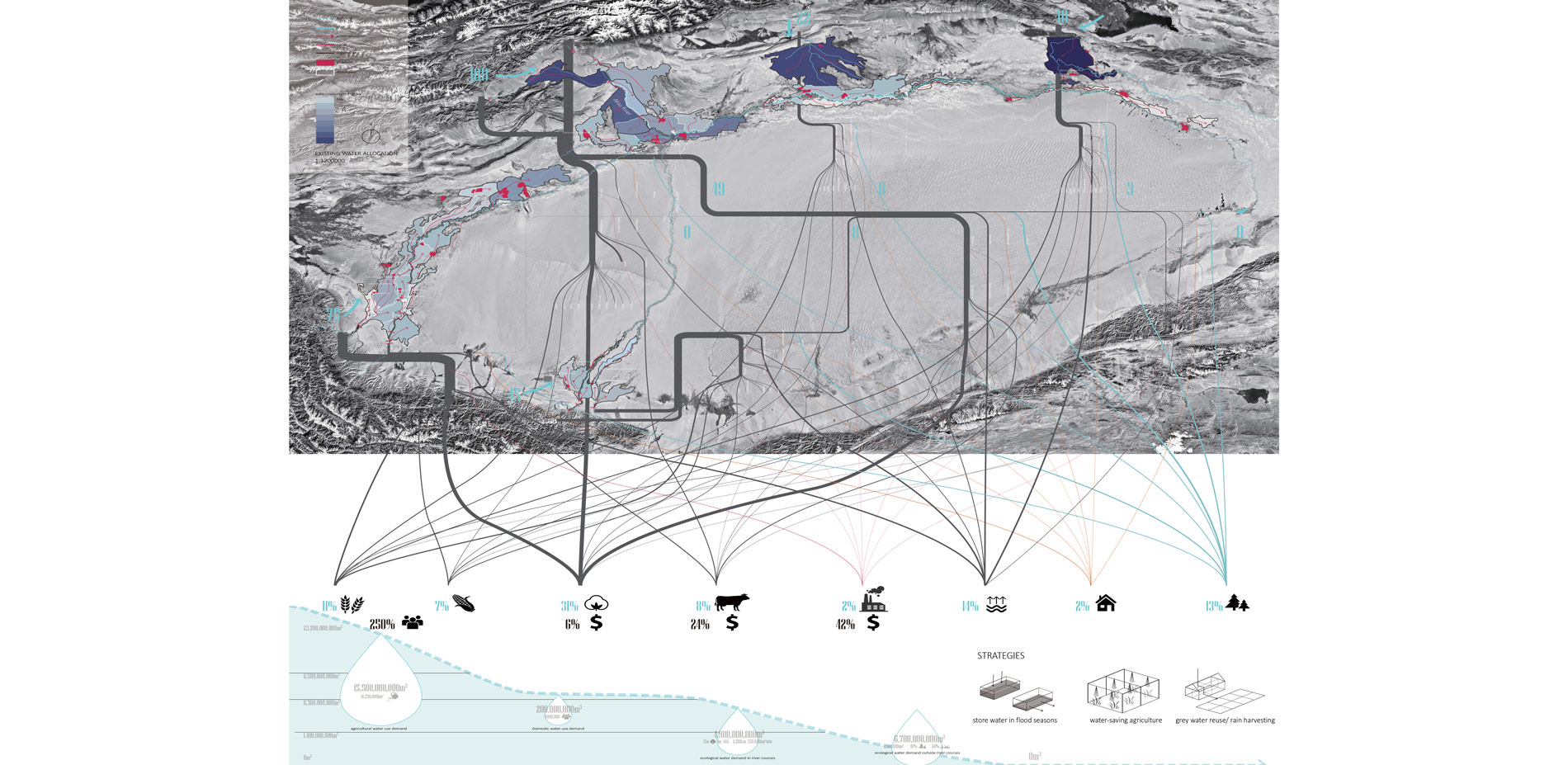
Existing Water Allocation
Agriculture takes up the water that should be provided to the river system. Water-saving agriculture, grey water reuse strategies and balancing water in different seasons are three strategies to save the river
Photo Credit: Zhuofan Wan
Media: Please submit high-resolution image requests to images@asla.org.
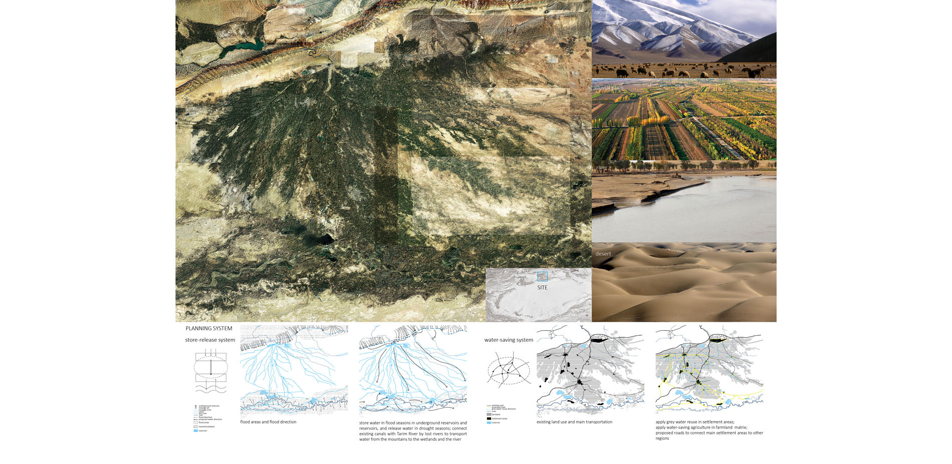
Planning Strategies
Two systems are built in the planning scale site to reconnect the tributary to Tarim River. The 1st one is the store-release system to balance water. The 2nd one is the water-saving system
Photo Credit: Zhuofan Wan
Media: Please submit high-resolution image requests to images@asla.org.

Master Plan and New Water Flows in Flood Seasons and Drought Seasons
Photo Credit: Zhuofan Wan
Media: Please submit high-resolution image requests to images@asla.org.
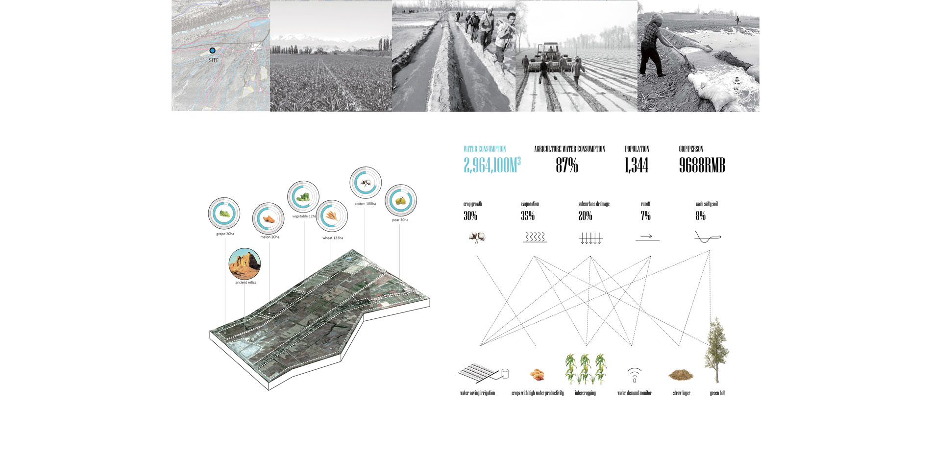
Design-Scale Site - Water-Saving and High-Productive Agriculture
Several strategies are created to deal with the water waste in agriculture
Photo Credit: Zhuofan Wan
Media: Please submit high-resolution image requests to images@asla.org.
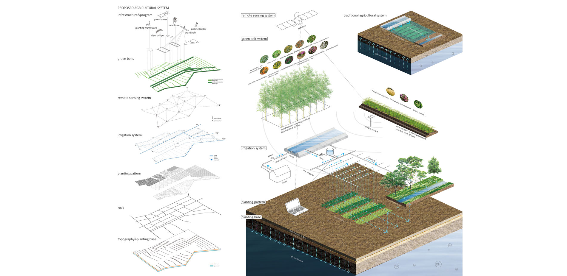
Proposed Agricultural Systems
Six agricultural systems are constructed to promote local economy and save water. They are planting base with a straw layer; intercropping planting pattern; drip irrigation with ecological ditches; remote sensing system; green belts; agricultural infrastructures.
Photo Credit: Zhuofan Wan
Media: Please submit high-resolution image requests to images@asla.org.
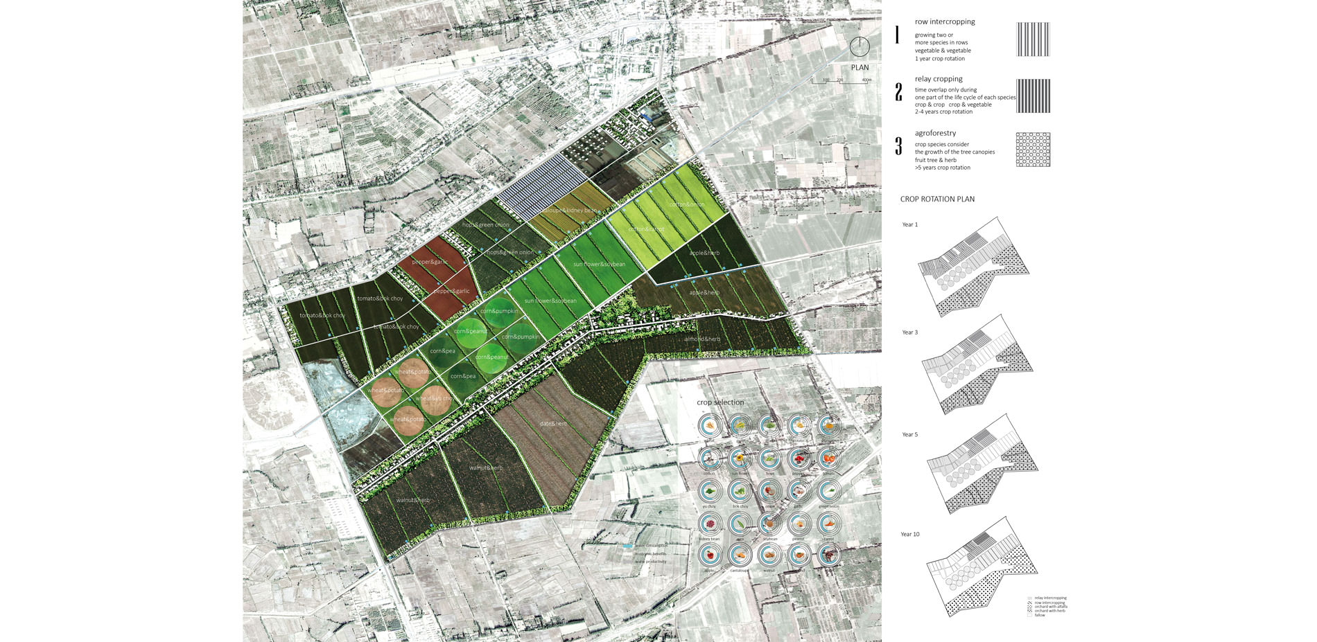
Plan
Crops with high water productivity and good markets are selected. Three types of intercropping planting patterns are designed with 10-year crop rotation. Each farm parcels will be round off in different years.
Photo Credit: Zhuofan Wan
Media: Please submit high-resolution image requests to images@asla.org.
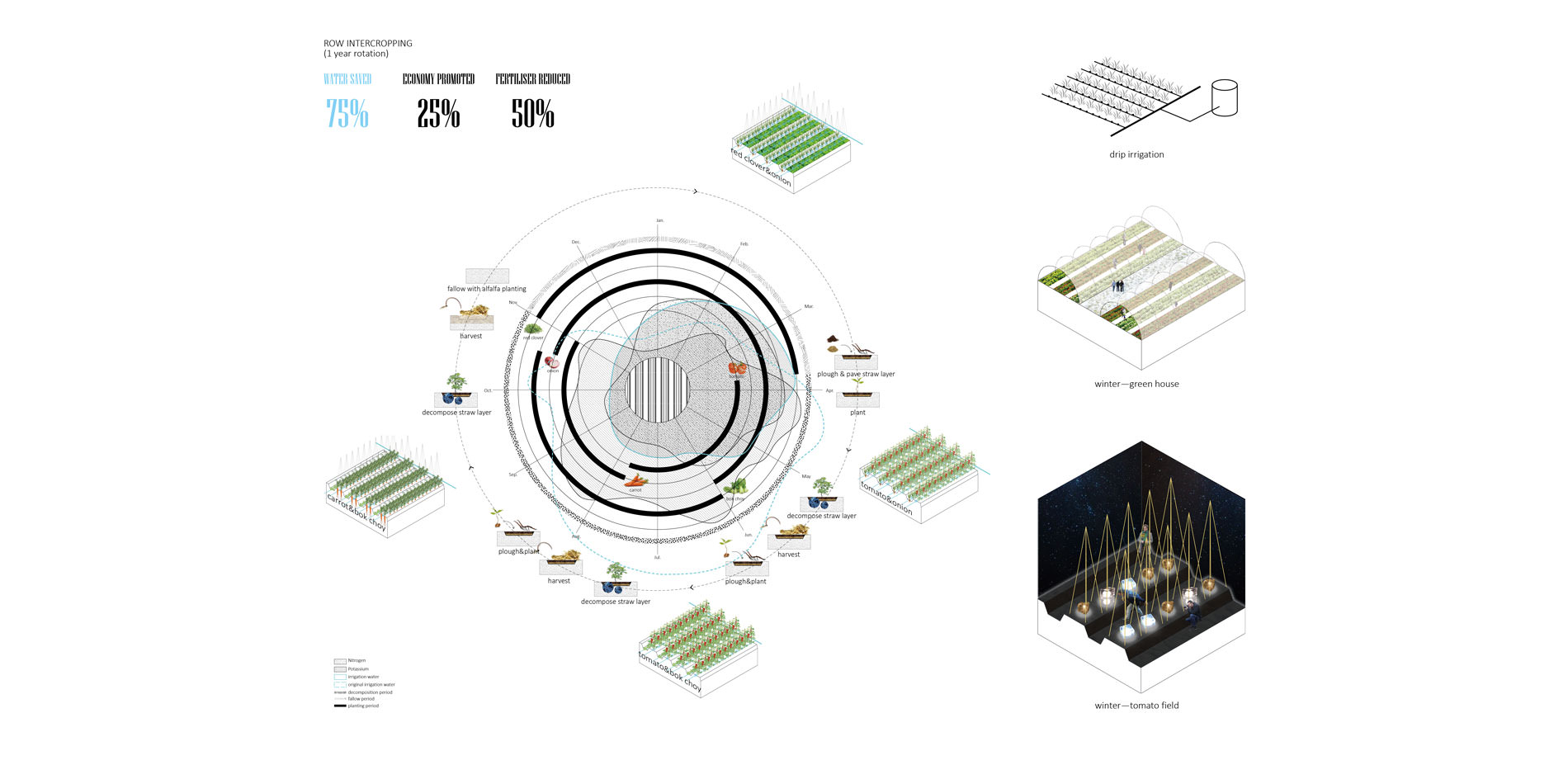
Row Intercropping
Row intercropping is always vegetable with vegetable and has only 1-year crop rotation. Drip irrigation is applied in this type. Various programs are provided for local people.
Photo Credit: Zhuofan Wan
Media: Please submit high-resolution image requests to images@asla.org.
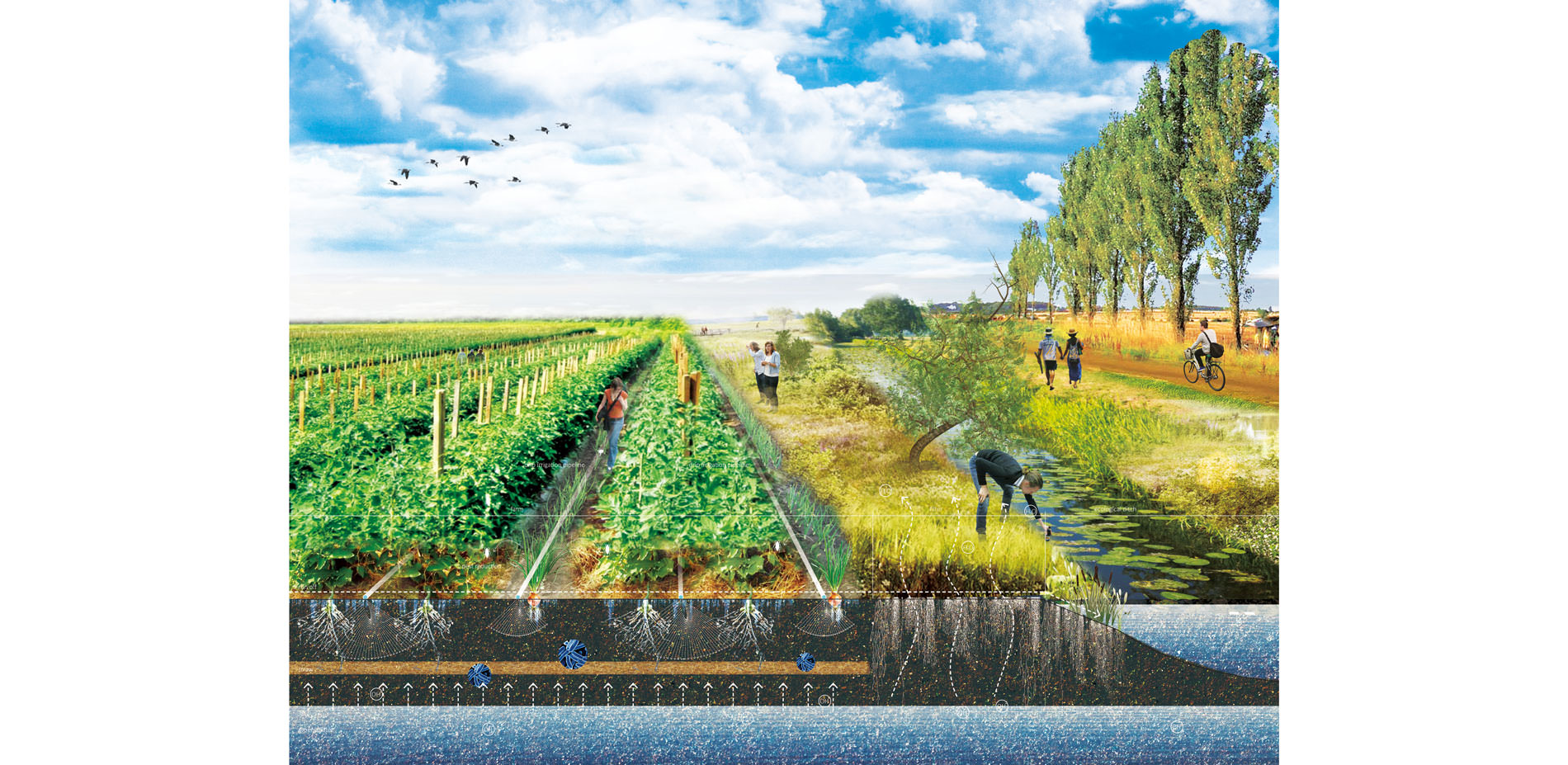
Photo Credit: Zhuofan Wan
Media: Please submit high-resolution image requests to images@asla.org.

Agrosforestry
Agroforestry is fruit trees with herbs, and has at least 5-year crop rotation. Drip irrigation is applied in this type. Various programs are provided for local people.
Photo Credit: Zhuofan Wan
Media: Please submit high-resolution image requests to images@asla.org.
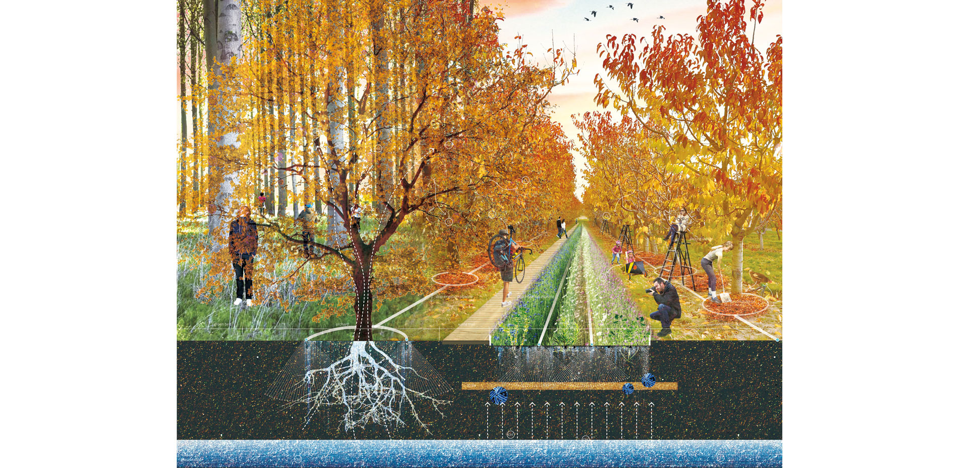
Photo Credit: Zhuofan Wan
Media: Please submit high-resolution image requests to images@asla.org.
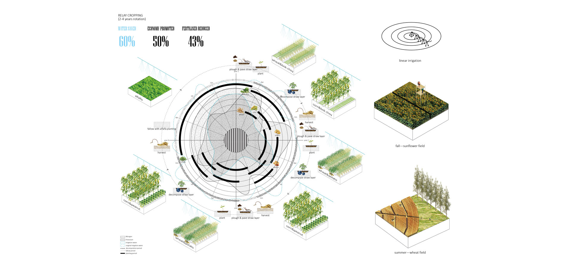
Relay Intercropping
Relay Intercropping is crops with crops or crops with vegetable in the design, and has 2-4 year-crop rotation. Linear irrigation is applied in this type. Various programs are provided for local people.
Photo Credit: Zhuofan Wan
Media: Please submit high-resolution image requests to images@asla.org.

Photo Credit: Zhuofan Wan
Media: Please submit high-resolution image requests to images@asla.org.
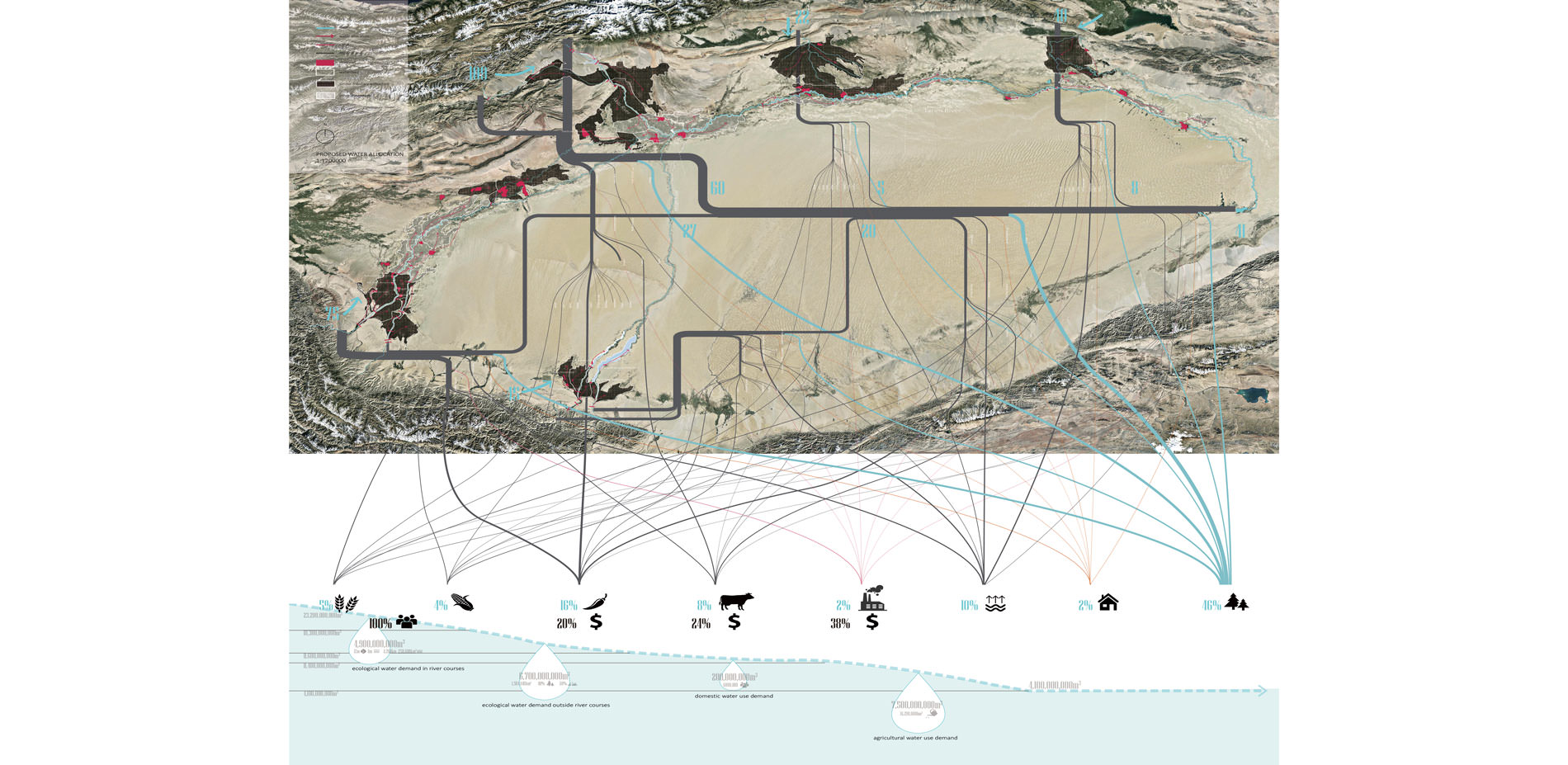
Proposed Water Allocation
Similar patches of the river system as the planning scale site are identified and could apply the same planning and design strategies. There is enough water to fulfill ecological water demand and support downstream riparian ecosystems in the proposed water allocation
Photo Credit: Zhuofan Wan
Media: Please submit high-resolution image requests to images@asla.org.


The environmental sensitivity is impressive. It’s very, very responsive to its setting in a really harsh climate.
- 2017 Awards Jury
PROJECT STATEMENT
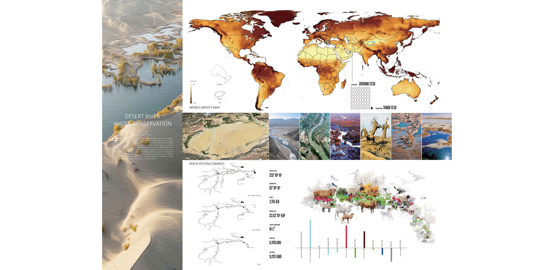
The arid zones on the Earth cover 30% or more of the global land surface and support an ever-growing human population. People living there are always facing drought problems. Rivers in these zones often play a critical role in people’s life, landscape changes, ecological evolution and socio-economic development. Besides the global warming, many dry land rivers have already been strongly influenced by the accelerated expansion of human activities in arid regions with the increased population, or even are under significant threat from various human interventions such as land reclamation and flow regulation. As riparian ecosystems are disturbed, people’s lives are affected and desertification is aggravated.
Tarim River, located in Taklamakan Desert, China, was selected as the testing ground to investigate water-balance and water-saving strategies to restore the degraded desert river, by balancing the desert river’s resilience and humans’ water demand and preventing middle and lower streams from disappearing in the desert, while at the same time improving socio-economic development.
PROJECT NARRATIVE
This project is about the desert river water conservation.
Tarim River in China with a 4762 km total length was selected as the site. The region has only 50mm precipitation/year, but 2000mm evaporation/year. The river is in a hyper-arid basin with closed watersheds. Its headwater originates from melted snow in the mountain regions. There’re large areas of farmlands along the river. The middle and lower streams traverse Taklamakan Desert and ends in Taitema Lake. 6,970,000 people are living here, relying heavily on the river for drinking and irrigation, over-exaction water from the river doesn’t bring a lot of benefits, but changed the shape of the river, many tributaries have disconnected to the mainstream, lower stream has broken water, complexity and diversity of the riparian ecosystems are reducing.
The project will investigate strategies to save the river, balance the desert river’s resilience and human’s water demand, preventing the middle and lower streams from disappearing in the desert, and rehabilitating riparian ecosystems while improving socio-economic development of the region.
Problems
First, the problems were checked to see where the water goes. Most of the water is allocated to agriculture, especially to the main cash crop-cotton, but brings small portion of economic benefits. Just 13% of water is allocated to ecologies. The water is allocated to agriculture first, then is domestic use, the last is the riparian ecosystem. The large amount of water used in agriculture takes up the water that should be provided to the river system. Strategies in this project are to apply water-saving agriculture in farmland, apply grey water reuse strategies and store extra water in flood seasons to reuse in drought seasons.
Planning
Zooming in the site, one of the tributary regions was selected as the planning scale site to delineate the strategies. The tributary has disconnected from the mainstream for several years, the region is from mountain region to fluvial plain, to Tarim River, finally to the desert from north to south. The flood seasons are from Apr. to Aug. every year, large areas of farms near the river and the mountain are flooded. In drought seasons, farms experience water scarcity, and much less water flows from upstream to down streams.
For the planning strategies, the 1st one is to build a store-release system. A series of underground reservoirs will be built along the seepage zones near the mountain. Working with reservoirs along the river, they’ll store extra water in flood seasons to recharge the riparian ecosystems and irrigate farmland in drought seasons. The 2nd one is to build a water-saving system. Grey water reuse strategies will be applied in settlement areas, and water-saving and high productive agriculture will be applied in large farmland matrix to save water and promote economy. The planning makes possibilities to connect the tributary to the river again.
Design
Zooming in the site, one of the farmland units in the planning site was selected to explain how the water-saving and high productive agriculture performs. Farms in the region is country-owned. The traditional agriculture applies flood irrigation, covers plastic film to reduce evaporation and plants crops with low water productivity, but just brings low income for local people. And only 43% of irrigation water is used to irrigate crops, other 57% is wasted. A considerable amount of water is lost by evaporation, runoff, subsurface drainage, wash salty soil, but not for crop production. Such loses of water from agriculture have major implication for not only to crop production, but also to movement of nutrients from agricultural fields to riverine environment and groundwater system. Any improvements in water use efficiency in agriculture increase the amount of water available for down steam users. Several strategies were applied on the site to deal with the water waste. They’re to apply water-saving irrigation, plant high water productive crops, build green belts, cover remote sensing system and apply intercropping planting method.
According to these strategies, several agricultural systems were constructed on the site.
- Planting base with a thin straw layer to lower groundwater table level and prevent soil salinization
- Intercropping planting pattern to promote water and soil productivity and reduce evaporation
- Drip irrigation with ecological ditches to promote water efficiency, reduce evaporation, soil salinization and runoff pollution.
- Remote sensing system to monitor water demand to irrigate more precisely
- 2 types of green belts to reduce sand and wind erosion, adjusting microclimate to promote agricultural productivity and reduce evaporation. Sand erosion control green belts consist of several 30-meter wide local trees and shrubs with west-east orientation. Wind erosion control green belts are composed of 2-metre high topography and local shrubs with north-south orientation.
- Some agricultural infrastructures are used for programs.
These systems aim to promote the economy and save water.
Crops with high water productivity and good markets were selected for the site.
There’re 3 types of intercropping planting pattern.
- The 1st is row intercropping, it’s always vegetable with vegetable and has only 1-year crop rotation
- The 2nd is relay cropping, it’s crops with crops or crops with vegetable, and has 2-4 year-crop rotation
- The 3rd is agroforestry, it’s fruit trees with herbs, and has at least 5-year crop rotation.
- Each farm parcel will be round off in different years.
Row Intercropping
One of the row intercropping typology designed on the site is tomato, bok choy, carrot and onion intercropped in a 1-year crop rotation. The straw layer is paved and then decomposed on the field in the rotation, and the field will be fallowed with red clovers in the winter. Drip irrigation is applied in this type of intercropping. Onions can reduce pesticide applied to the farm. This type of intercropping can provide various programs for local people in different seasons. In this type, 75% water can be saved, economy can be promoted 25%, 50% of fertilizer can be reduced compared with the traditional agriculture.
Agroforestry
One of agroforestry typology designed on the site is apple trees with herbs in an 8-year crop rotation. Herbs will be changed with the growth of the apple tree canopies, and in the last 2 years, the under layers will be fallowed with alfalfa planting. Drip irrigation is also applied in this type. There’re also various programs in different seasons for local people. In this typology, 54% of water can be saved, economy can be promoted 120%, 20% fertilizers can be reduced.
Relay Intercropping
One of relay cropping designed on the site is wheat, corn, peanut, potato and bok choy intercropped in a 4-year crop rotation. The straw layer is paved and then decomposed on the field in the rotation. In the 4th year the farm will be in fallow period with alfalfa. And the Potassium and Nitrogen nutrition levels will also change with the help of peanuts and potatoes. Linear irrigation is applied here. There’re various programs for residents as well. This planting pattern helps to save about 60% of water, economy can be promoted 50% and fertilizers can be reduced 43%.
At last, similar patches of the river system as the planning scale site were identified and they could apply the same planning and design strategies. In the proposed water allocation, 46% of water is allocated to ecology, which can fulfill ecological water demand. There is enough water to support downstream riparian ecosystems.