


Honor Award
Envisioning Francisville's Future
Sue Ann Alleger, Student ASLA; Anna Anisko, Student ASLA; David Bilinski, Student ASLA;
Holly Bonacum, Student ASLA; Kristen Brown Student ASLA; Cindy Culp, Student ASLA; Felicia DiPietro, Student ASLA; Nickia Dixon, Student ASLA; Diana Fernandez, Student ASLA; Josiah Gerhart, Student Affiliate ASLA; Aaron Karnas, Student ASLA; W. John Keiser, III, Student ASLA; Dennis Murphy, Student ASLA; Matthew Nelson, Student ASLA; Jeff Oyler, Student ASLA; Leah Purdy Student ASLA; Donna Shumpert, Student ASLA; John Sloan, Student ASLA; Andrew Slot, Student ASLA; Kelsey Stanton, Student ASLA; Amy Syverson, Student ASLA; John Tallon, Jr., Student ASLA and Patrick Whealton, Student ASLA, Undergraduate, Temple University
Faculty Advisors: Pauline Hurley-Kurtz, ASLA and Robert Kuper, ASLA
 Close Me!
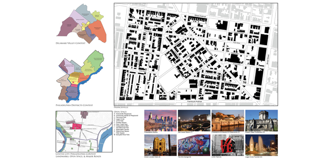
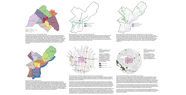
Transportation and Open Space. Transportation and open space context maps present the current status of regional and local public transportation and parks. This gives a framework for designing a “transit oriented” neighborhood and for increasing open space within Francisville.
Download Hi-Res ImageImage: Matthew Nelson
Image 2 of 16
 Close Me!
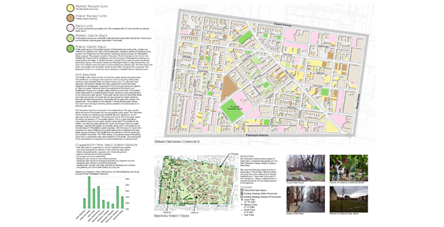
Existing Open Space, Vacant Lots, and Street Trees. An analysis of existing open space vacant lots and street trees as a precursor to developing an open space network in Francisville.
Download Hi-Res ImageImage: Matthew Nelson
Image 3 of 16
 Close Me!
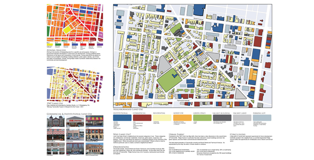
Land Use and Zoning. Land Use analyses and zoning regulations were crucial to understanding existing conditions in Francisville and planning for future development. Understanding the land use and zoning allows us to determine the overall character of the neighborhood.
Download Hi-Res ImageImage: Matthew Nelson
Image 4 of 16
 Close Me!
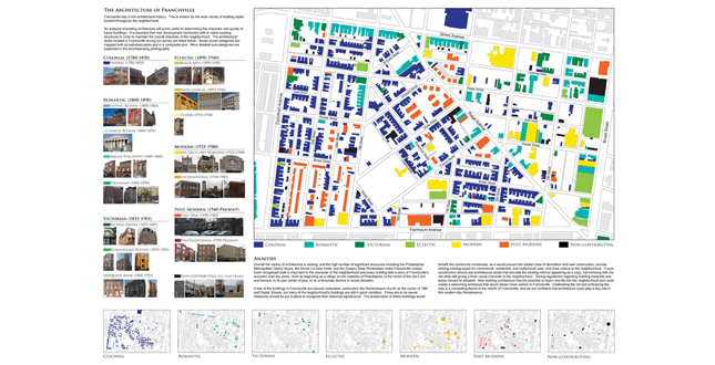
Architectural Character. The architecture throughout the neighborhood showcases Francisville’s rich history. The patterns shown in the maps above indicate how Francisville has evolved over the years.
Download Hi-Res ImageImage: Matthew Nelson
Image 5 of 16
 Close Me!
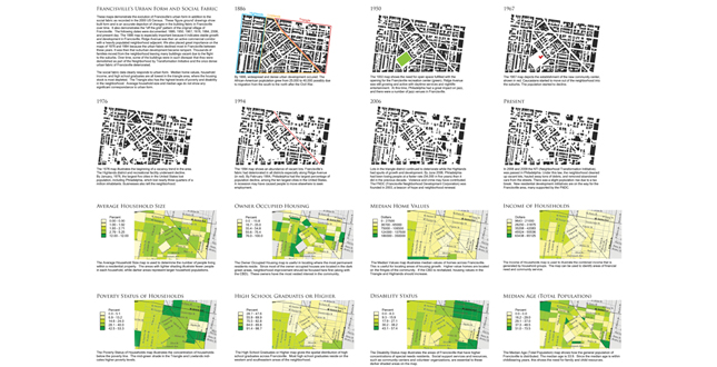
Urban Form and Social Fabric. A study of both the urban and social structure of Francisville. The data illustrates how the urban form in Francisville has changed over the years, and the social response to that change.
Download Hi-Res ImageImage: Matthew Nelson
Image 6 of 16
 Close Me!
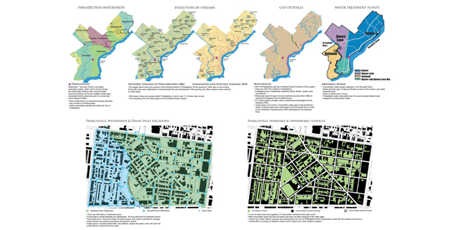
Street to Stream: Natural and Artificial Hydrology. A comprehensive analysis of the entire hydrologic cycle of Francisville reveals a common urban concern of the 21st Century: stormwater and combined sewer overflow systems.
Download Hi-Res ImageImage: Matthew Nelson
Image 7 of 16
 Close Me!
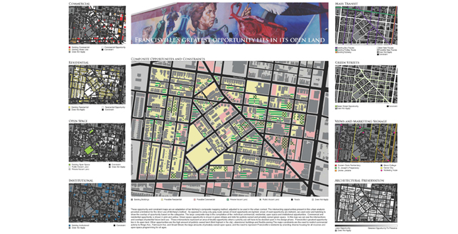
Opportunities and Constraints. A comprehensive analysis and synthesis of Ian McHarg’s opportunities and constraints method in the Francisville neighborhood.
Download Hi-Res ImageImage: Matthew Nelson
Image 8 of 16
 Close Me!
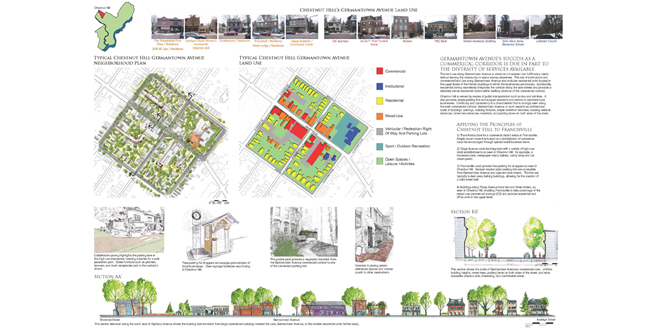
Germantown Avenue, Chestnut Hill: Commercial Corridor. Germantown Avenue in Chestnut Hill was chosen as a model commercial corridor along a major transit route within a thriving, mixed-use, walkable community. This has many potential applications for Ridge Avenue in Francisville.
Download Hi-Res ImageImage: Matthew Nelson
Image 9 of 16
 Close Me!
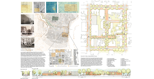
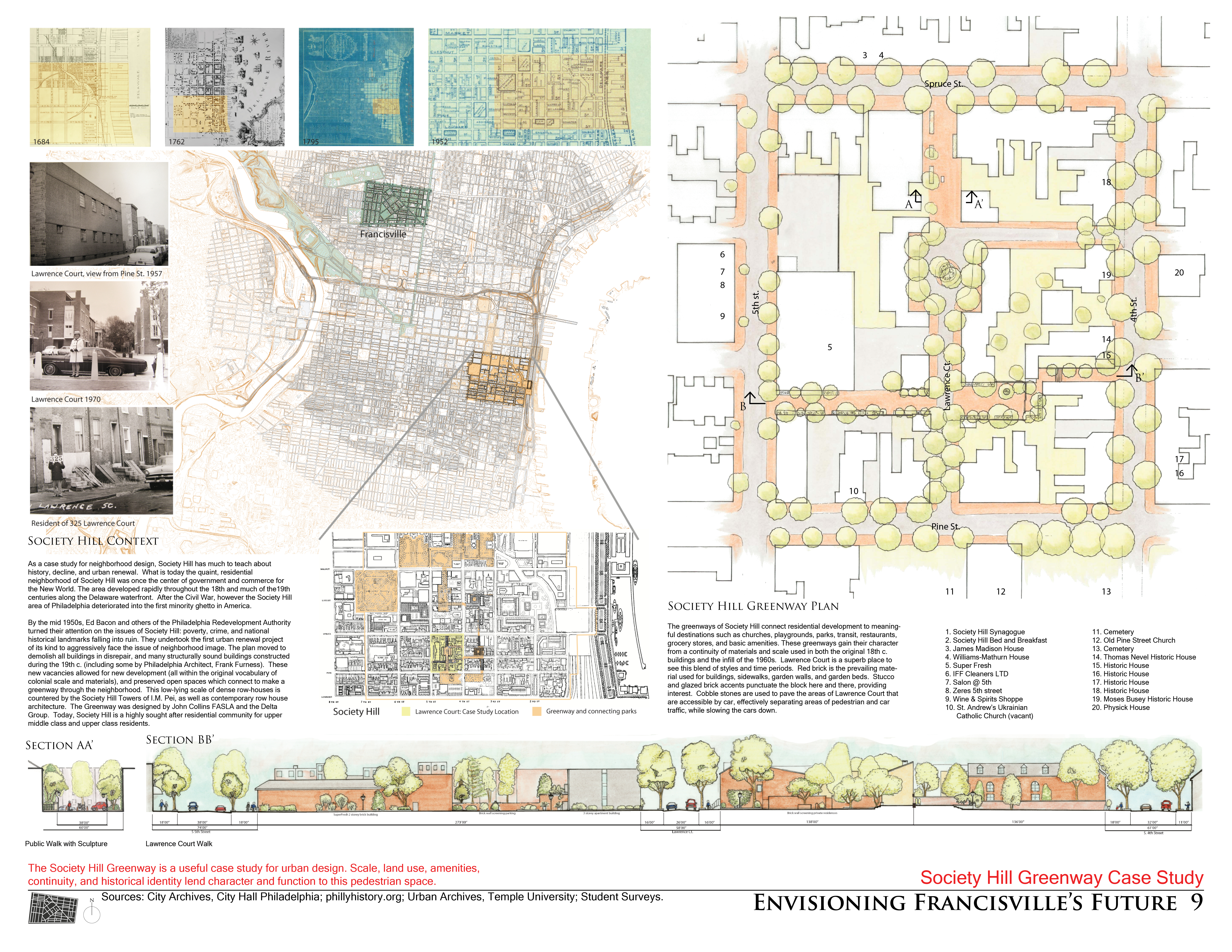
Society Hill Greenway Case Study. The Society Hill Greenway is a useful case study for urban design. Scale, land use, amenities, continuity, and historical identity lend character and function to this pedestrian space.
Download Hi-Res ImageImage: Matthew Nelson
Image 10 of 16
 Close Me!
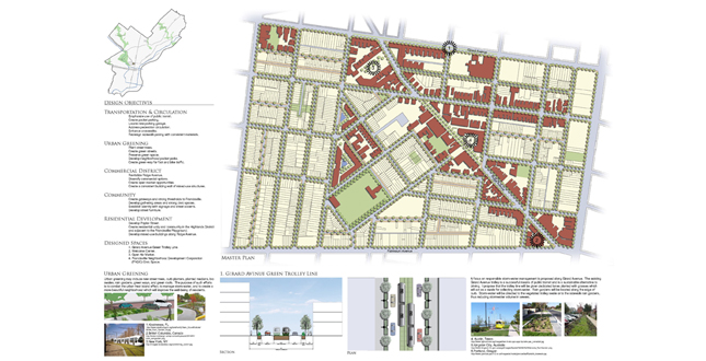
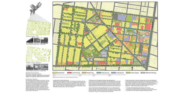
Master Plan 1A: Creativity • Commerce • Community. This Master Plan focuses on creating a transit oriented development with emphasis on community, commerce, and sustainability while maintaining Francisville’s rich history.
Download Hi-Res ImageImage: Matthew Nelson
Image 11 of 16
 Close Me!
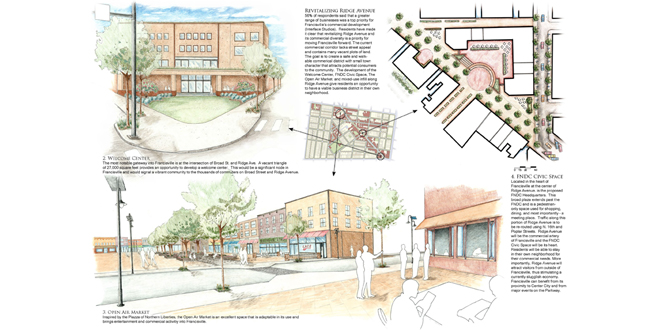
Master Plan 1 B: Creativity • Commerce • Community — Revitalizing Ridge Avenue. A major focus is the revitalization of Ridge Avenue, through the addition of a welcome center, a civic space and plaza, and an open air market.
Download Hi-Res ImageImage: Matthew Nelson
Image 12 of 16
 Close Me!
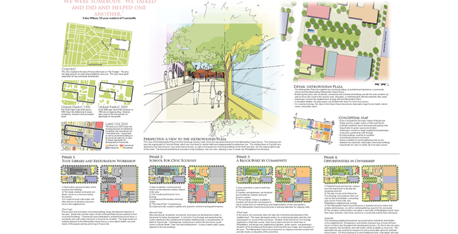
Master Plan II A: Living the Dream. This master plan responds to the FNDC priorities of environmental and socially responsible development by disturbing existing structures and sues as little as possible. The plan focuses on ideal land use for TOD and economic growth.
Download Hi-Res ImageImage: Matthew Nelson
Image 13 of 16
 Close Me!
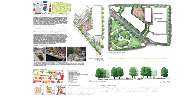
Master Plan II B: Living the Dream — Metropolitan Neighborhood Revitalization. A phased plan for redevelopment focuses on the potential of pre-existing structures and the possibility of community led development. This plan strives for positive change to be called for a supported by those who live and work in Francisville.
Download Hi-Res ImageImage: Matthew Nelson
Image 14 of 16
 Close Me!
Master Plan II C: Living the Dream — Community Focused Gateway. A welcoming gateway is an important part of any community. A properly designed gateway can attract people into a neighborhood who would otherwise be simple passing by.
Download Hi-Res ImageImage: Matthew Nelson
Image 15 of 16
 Close Me!
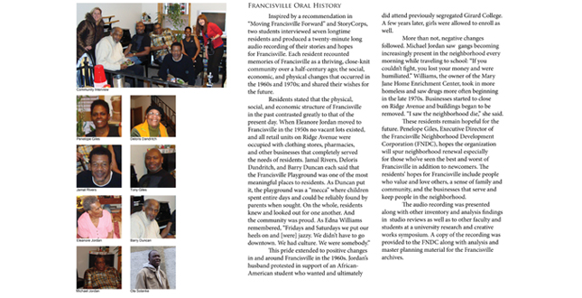
Community Interview Summary. A twenty-minute audio recording of residents’ stories illustrate how the physical form of the neighborhood, the relationships between residents, and the economy changed over the last half-century.
Download Hi-Res ImageImage: Matthew Nelson
Image 16 of 16
Project Statement
'Envisioning Francisville's Future' is a comprehensive analysis and planning project based in the socially, economically, and physically degraded Philadelphia neighborhood of Francisville. Sophomore landscape architecture students undertook a unique, thorough process of studying and applying lessons from planning and design texts, local case studies, an extensive site inventory and analysis; community aspirations; sustainable initiatives, and the McHargian method of regional analysis to develop team-based transit-oriented development (TOD) master plans.
Project Narrative
—2011 Student Awards Jury
Introduction
The 'Envisioning Francisville's Future' project is located within the Philadelphia, Pennsylvania neighborhood of Francisville, which has experienced a half-century of social and economic depression including a large residential migration, decay of the neighborhood's physical form, and the loss of significant commercial activity. In 2001, the City began the Neighborhood Transformation Initiative and created many empty lots in Francisville by demolishing dilapidated structures. Since 2003, the Francisville Neighborhood Development Corporation (FNDC) has sought to revitalize the neighborhood by viewing abandoned lots as an opportunity for infill housing, encouraging commercial ventures, and implementing initiatives that aspire to make Francisville the greenest neighborhood in Philadelphia.
Project Goal and Objectives
The goal of this project was to teach undergraduate landscape architecture students the process of developing a sustainable community revitalization plan in an urban setting. Students were expected to understand the social, cultural, economic, and ecological aspects of Francisville; acknowledge recent city planning principles and urban greening initiatives; accomodate residents' needs and desires; and work in a team to incorporate this knowledge in master plans wherein Francisville's urban fabric is restored and a diverse, active community may live in the future.
Environmental and Social Inventory & Analysis
Three tasks comprised the inventory and analysis: first, students were required to read texts that would provide them with theoretical, practical, and site-specific knowledge. Second, students undertook investigations of local precedents focusing on dense urban form, a viable commercial corridor, and the integration of a green network within an urban fabric. Third and finally, students completed an extensive inventory and analysis of various aspects of Francisville and Philadelphia from zoning codes to hydrology and land use to architectural style.
Studio Readings
Three texts guided the analysis, inventory, and design efforts of this project. Kevin Lynch's The Image of the City presented students with a framework to understand residents' image(s) of Francisville in terms of landmarks, edges, districts, nodes, and paths, and how the image may be improved or enhanced by design. The Next American Metropolis: Ecology, Community and the American Dream by Peter Calthorpe provided the historical and theoretical reasoning for encouraging transit-oriented development (TOD) as well as the practical guidelines and criteria for implementing them. A comprehensive master plan produced in 2007 by Interface Studio, LLC., of Philadelphia, entitled “Moving Francisville Forward: A Blueprint for the Future” supplied students a substantial body of work from which to learn and verify the history and future desires of the community.
Case Studies
Three case studies were performed in separate Philadelphia neighborhoods, each serving as a model for a specific aspect of design that could be adopted and adapted to Francisville. First, the neighborhood of Fairmount, adjacent to Francisville, was chosen as a model of urban density for its closely spaced two- and three-story row homes that create a solid street wall necessary to making Francisville a place again. Students were required to field-measure and hand-draft one neighborhood block to understand its physical dimensions. Chestnut Hill was chosen as a model for its thriving mixed-use, walkable commercial corridor - Germantown Avenue. Continuity there is seen in the scale of buildings, awnings, facades, ample storefront windows, uniform building setback and street tree distances, locally-sourced building materials, and on-street parking. Students were required to document the surrounding context, materials, select dimensions, and variety and location of uses using photographs, diagrams, and digital or hand drawings. A similar method was employed when students analyzed Society Hill, a model of an urban green network within an historic residential neighborhood. Like Francisville, it was once a strong commercial area that has suffered population decline, poverty and urban blight, and has been the subject of a redevelopment plan. Now a sought-after address for upper-middle and upper-class residents, this community successfully includes open space and greenway corridors, mixed-use commercial, institutional and residential areas and human-scaled street furniture.
Site Inventory and Analysis
A comprehensive site inventory and analysis was undertaken to understand the social, ecological, and physical aspects of Francisville. Unless otherwise noted, students retrieved information via site visits and GIS maps and presented their findings digitally using a variety of computer programs. Regional, City, and Neighborhood Context inventory and analyses encapsulated scalar relationships including but not exclusive of mass transit, open space, community and civic organizations, land ownership, landmarks, physiographic regions, and surface waterways. The evolution of the urban fabric traced the fluctuation of building density within Francisville at eight distinct times using figure-ground drawings created from maps at the Philadelphia Free Library. Landforms examined topography, building height, views, and the urban heat-island effect. Data from the U.S. Census Bureau including poverty status of households, owner occupied housing, and disability status of residents was mapped to understand where various types of housing and services might be concentrated in design. The Philadelphia Zoning Code was investigated to grasp the dimensional parameters within which the students must design. Land use was examined on scales ranging from the neighborhood to street showing the large-scale concentrations and patterns of land uses to the small-scale variety of retail, office, and service-oriented businesses that exist in Francisville. The architectural style of the buildings within Francisville were catalogued and examined to identify the various styles and the locations in which they are concentrated. Using information from “Moving Francisville Forward”, site visits, and the City of Philadelphia, the open spaces between buildings were categorized in terms of various forms of ownership, care, and surface condition. The artificial and natural hydrology of Philadelphia and Francisville were analyzed in terms of their need and potential for introducing stormwater BMPs and envisioning Francisville as the greenest neighborhood in Philadelphia. Finally, some of Francisville's residents shared their memories and dreams for the neighborhood in interviews that were recorded and edited into a twenty-minute long audio recording.
Community Involvement
Beyond these recordings, Penelope Giles, Executive Director of the FNDC, gave students a guided tour of Francisville and later reviewed the above analysis with a member of the Philadelphia City Planning Commission and an Associate of Interface Studio. Students incorporated the juror's comments into opportunities and constraints drawings that were used to guide infill design. Students began this phase of design by applying the McHargian method of regional analysis and site selection outlined in Design with Nature.
Master Plans
Eight teams comprised of three to four students created master plans that sought to synthesize the above analysis in the design studio. Two are included within this submission:
- 'Living the Dream' is a five-year masterplan comprised of phases that structurally retrofit commercial and residential buildings to attract new residents and businesses, preserve green space for passive recreational parks, and locate training facilities where citizens can be taught and empowered to sustain the community. More detailed designs of the Metropolitan plaza area and a gateway to Francisville are also included.
- 'Creativity, Commerce and Community' places emphasis on public transportation, the design of pocket parks, and enhancement of pedestrian circulation through use of crosswalks and consistent sidewalk and street furniture materials. An Urban Greening Plan will create green streets (street trees, rain gardens, and curb planters) through the preservation of green space during development. A welcome center serves as a gateway node for the revitalized Ridge Avenue commercial corridor along which an open air market and FNDC Civic Space are proposed.
These master plans and neighborhood designs were presented before members of the community in Francisville for their feedback. All of the above was made available to the FNDC in hard copy and digital form at their request, and to maintain and further the interest in revitalizing Francisville. Students also spent a day working on two community-service projects that were planned outside of and prior to the studio: setting posts in a vineyard and installing fence rails and a trellis in the community garden.
Additional Project Credits
Francisville Neighborhood Development Corporation (FNDC)
Penelope Giles, Director;
Tony Giles
City of Philadelphia
David Fecteau, Planner
Interface Studio
Mindy Watts, Planner, Associate