

«previous pageANALYSIS & PLANNING CATEGORY
Honor Award
Trinity River Corridor Design Guidelines, Dallas, TX
Wallace Roberts & Todd, LLC, Dallas, TX
client: City of Dallas, Trinity River Corridor Project
Project Statement
The Trinity River Corridor Design Guidelines will establish the character and measure of sustainability for the largest green infrastructure initiative in the United States — a 9-mile urban park, floodway and transportation improvement project that will anchor the transformation of central Dallas into a quilt of mixed-use and transit-oriented neighborhoods. The scope, scale and design challenges posed by this project are unique; they also serve to underscore the role of green infrastructure in re-casting cities as sustainable environments.
Project Goals and Objectives
“To create a didactic landscape unlike any other: where art and sustainability will be coexist throughout the built form, advancing the city’s most progressive goals and values, where infrastructure will be rendered green infrastructure, where vastness will be sensed and understood alongside the minute, and where Dallas will rediscover and redefine itself.”
The context of this design goal is a river channel coursing down the middle of a 2,300-acre mostly inaccessible, barren floodway separated from the city by 35-foot earthen levees—a barrier between Downtown Dallas to the east and residential communities to the west. In envisioning the transformation of the corridor, key design objectives were advanced before the City and stakeholders:
- A landscape that is at once ecologically viable, educational, offering diverse opportunities for recreation and exercise, and functioning as a connective tissue between adjoining communities.
- A landscape that provides a high degree of ecological service, from carbon sequestration, water recycling and bio-filtration, to the production of energy from renewable resources.
- A landscape that restores access and beauty to the Trinity River, and enhances the floodplain as an expression of the Texas Blackland Prairie.
- A landscape that integrates infrastructure — power transmission, transportation, flood protection and conveyance — within the context of ecology and recreation.
- A landscape that embraces art, from the conception of landforms and its material quality to the provision of venues for major works — permanent and temporary.
Design Approach
The Design Guidelines were commissioned by the City to “fix” the physical identity of the Trinity River Corridor in furtherance of the 2003 Balanced Vision Plan, a plan that secured public consensus for the project’s main features: recreational lakes supplied with reclaimed waste water, the relocation of the Trinity River channel to include meanders and riparian habitat, and the location of the Trinity Parkway, a 6-mile by-pass toll road within the floodway.
Three critical conditions are addressed:
- The entire park will be subject to periodic flooding, potentially submerging all recreational features under more than 23 feet of water at the 100 year flood elevation.
- All improvements will be subject to US Army Corps of Engineers flood protection reviews and approvals.
- Long-term maintenance and operations cannot impose upon the City Parks and Recreation Department an extraordinary financial burden.
In response, about 80 percent of the park area is reserved for low-maintenance landscapes that can naturally withstand flood events: prairie grasses, wetlands, riparian buffers, bottomland woodland and recreational lakes. The number and location of canopy trees — more than 12,000 — directly support hydrologic control of downstream flood velocities. The remaining 20 percent of the park — about 480 acres — are devoted to more intensively used trails and promenades, amphitheaters, play areas and athletic fields. Most of these features are proposed above the 2-year flood elevation to reduce maintenance and operation requirements. The combination of proposed landform, vegetation and built elements — including the Trinity Parkway — have been calibrated to safely convey a Standard Project Flood, which is equivalent to the 800-year flood event.
In arriving at this approach, the design team availed itself with the expertise of recognized park maintenance, operations and security consultants. Ongoing collaborations with a public artist, lighting designer, fountain consultant, civil engineers, biologists, as well as experts in bio-filtration, water quality, fluvial morphology, transportation and wayfinding also took place on a consistent and coordinated basis.
Periodic and detailed reviews of the design proposals were undertaken by City officials, especially-formed public review bodies, not-for-profit project supporters, and key stakeholders such as adjoining land owners and recreation advocates. The Design Guidelines were approved in August of 2008.
Key Design Proposals
The River: Practically the entirety of the Trinity River from the confluence of the Elm Fork and West Fork to the entrance to the Trinity Forest — a 9-mile course adjacent to the city’s Downtown — is proposed to be relocated to make room for the Trinity Parkway and recreational lakes. River channel meanders, an oxbow lake, emergent wetlands and multi-level riparian terraces are proposed to improve water quality and to establish the new river alignment as a viable end-to-end wildlife corridor.
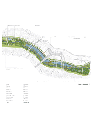
Eco-Types: About 90 percent of the park’s 2,300 acres will become a newly made landscape including mowed turf (13%), meadow (32%), bottomland woodland (10%), riparian river terraces (3%), wetlands (13%), river (10%), lakes (12%) and urban parkland (7%). All proposed plant communities and species are native or naturalized, designed to evoke the full gamut of the Texas Blackland Prairie landscape.
Trails: More than 30-miles of trails are proposed within the floodway, facilitating jogging and walking as well as equestrians and commuter cyclists. A 20-foot wide primary trail meanders across the river, providing equal access to the park from both Downtown and West Dallas. Limited trailhead parking is provided; rather, public transit facilities are under consideration in support of the park and system of trails.
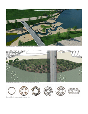
Public Art: The guidelines propose a three-part art program: site-specific temporary works scattered throughout (bi-annual events); one single major permanent work, strategically located on the Central Island; and 12 or so “Council Circles” — placed “off the beaten path” for contemplation and education, each designed by a different artist.
Parkway: The Trinity Parkway portion of the guidelines call for a variety of green design measures, including wind turbines (to take advantage of its perched elevation), solar panels for visual attenuation, harvested rain water for irrigation, bio-filtration wetlands for storm runoff control, and vegetated vertical walls (GSky system) to dampen sound, control glare and absorb carbon emissions. A combination of median and shoulder plantings intend to blur the line between the park and the parkway, eliciting the perception that the vehicles are “visitors” in what is otherwise a public recreation and habitat resource.
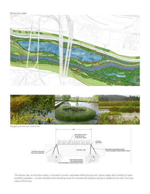
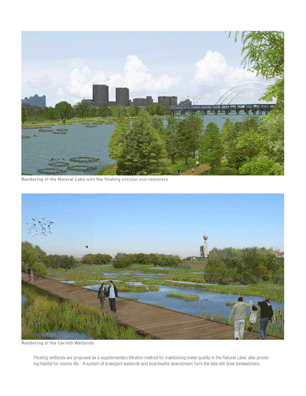
Eco-restorers: Working in conjunction with a national bio-filtration expert, about 3.5-acres worth of floating wetlands are proposed in the 60-acre “Natural Lake” to help naturally polish the lake waters and provide habitat for fish and freshwater invertebrates. Consisting of dispersed 80-foot diameter rings filled with aquatic plants, the restorers will offer didactic evidence of the park’s function as green infrastructure.
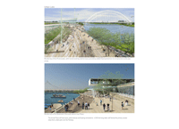
Promenade: A mile-long promenade is proposed along the Downtown side of the “Urban Lake” for casual strolling. A combination of water walls and perched cypress wetland ponds are proposed as a backdrop, part of a lake aeration and bio-filtration strategy. Over 80 percent of the promenade will be shaded for micro-climate attenuation purposes.
Isthmus: Stepped, stone terraces with carved channels for canoeing and kayaking are proposed between the Natural and Urban Lakes. This Isthmus will also provide a fording place across the lakes reminiscent of the chalky limestone shoals that exist as the geologic substrate and which enticed early Europeans to settle the area.
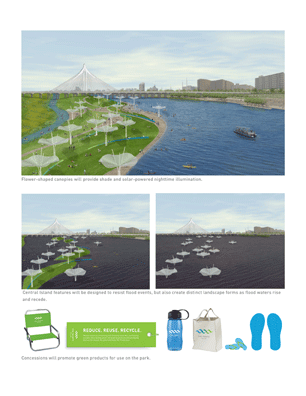
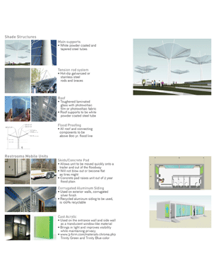
Central Island: A narrow, 2-mile long strip of parkland is proposed between the Natural and Urban Lakes and the relocated Trinity River channel. As the only unprogramed turf area of the park, this “island” will function as a locus for civic gatherings and celebrations. Flower-like shade structures will dot the island, covered with PV fabric that will power nighttime illumination.
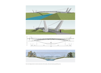
White Water Run: Perched 17 feet above the river’s normal flow elevation, the Urban and Natural Lakes will drain into the river through a 2,000-foot outlet channel. The Urban Lake water elevation will be periodically raised two feet to increase the flow through the Outlet Channel, providing stone-lined white water conditions along 2/3 of its length.
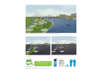
West Dallas Lake: The guidelines call for the creation of a 120-acre, 18-foot deep lake adjacent to several West Dallas communities, helping to satisfy the need for Parkway fill. The lake geometry affords an Olympic-sized rowing course, with water lilies supported by suspended underwater mats separating every two lanes. The water lilies, as well as “solar bees” (floating, solar-powered aerators) will help to sustain water quality.
Implementation
The Trinity Parkway will be constructed as a for-profit venture by a state tollway authority. Through an agreement with the City of Dallas, the tollway authority will also build the lakes and provide funds for five key park access points. The Landscape Architect defined the access points and helped secured approval of the design guidelines with the tollway authority as a prerequisite for detailed documentation of the roadway by third parties, which is currently underway.
Funds for the park are forthcoming from City, State and Federal sources, as well as private donations. The design team has been instrumental in promoting and explaining the significance of the park as a vital green infrastructure, helping to draw funding support from civic organizations, private donors and the development community. With the approved design guidelines in hand, the design team is currently working on the detailed documentation for a $300 million first phase of park development to be completed in 2014.
Project Resources
Project Management
CH2MHill
Transportation & Environmental Engineering
URS-LOPEZGARCIA (formerly LOPEZGARCIA GROUP)
Public Art
Brad J. Goldberg, Inc.
Graphic Identity and Way-finding
EBR Graphic Design
Lighting
Leni Schwendinger Light Projects, LTD
Architects
Ten Arquitectos
Ecological Restoration & Treatment
John Todd Ecological Design
Environmental Consultation
Outdoor Comfort Consultants
Fountain Design
CMS Collaborative
Operations & Maintenance
ETM Associates, LLC
Security Analysis & Design
Defenbaugh & Associates, Inc.
Access and Circulation
Bowman-Melton Associates
Lakes Outlet Channel Design
S2O Design and Engineering
Ecological Designer
Betsy Damon
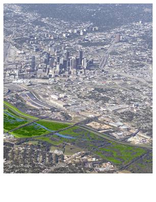
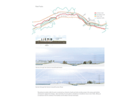
The Trinity River Corridor will be didactic landscape unlike any other where are and sustainability will coexist throughout the built form, advancing the citys most progressive goals and values; where infrastructure will be rendered green infrastructure; where vastness will be sensed and understood alongside the minute, and where Dallas will rediscover and redefine itself. (Photo: Wallace Roberts & Todd, LLC (WRT))
(Photo: Wallace Roberts & Todd, LLC (WRT))
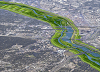
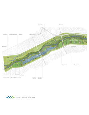
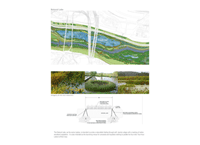
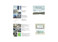
Trinity Corridor Park Plan (Photo: Wallace Roberts & Todd, LLC (WRT))
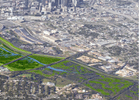
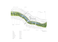
Trinity Corridor Park Plan (Photo: Wallace Roberts & Todd, LLC (WRT))
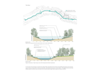
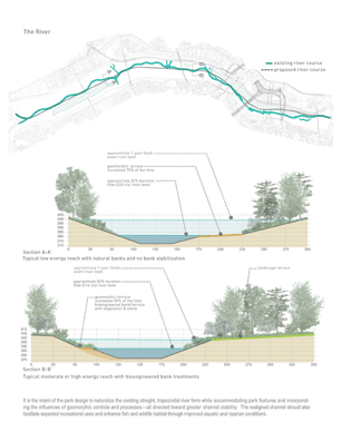
The River: It is the intent of the park design to naturalize the existing straight, trapezoidal river form while accommodating park features and incorporating the influences of geomorphic controls and processes — all directed toward greater channel stability. The realigned channel should also facilitate expected recreational uses and enhance fish and wildlife habitat through improved aquatic and riparian conditions. (Photo: Wallace Roberts & Todd, LLC (WRT))
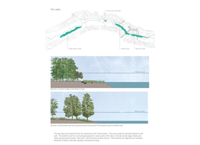
The Lake: The park lakes will provide the fill for the construction of the Trinity Parkway. They also provide the essential attraction for the park. The Guidelines call for a multi-pronged approach to water quality for the lakes, to include riparian edges, floating wetlands, perched cypress ponds, solar bees, and mechanical aerators and jets. These features are integrated with recreation demands for fishing, water play, kayaking, canoeing and rowing. (Photo: Wallace Roberts & Todd, LLC (WRT))
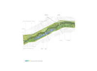
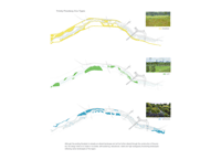
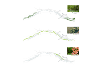
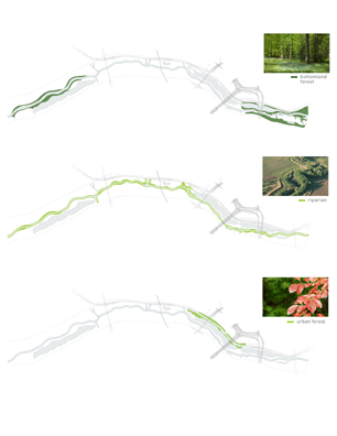
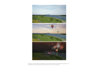
Trinity Floodway Eco-Types: Although the existing floodplain is already an altered landscape and will be further altered through the construction of the project, the design intent is to create or re-created, self-sustaining, educational, viable and high ecologically functioning landscapes reflecting native landscapes of the region. (Photo: Wallace Roberts & Todd, LLC (WRT))
Trinity Floodway Eco-Types (Photo: Wallace Roberts & Todd, LLC (WRT))
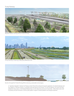
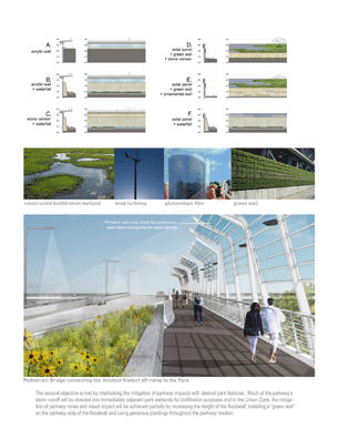
Trinity Parkway: A seamless integration between the Parkway and the Park will be achieved through the application of a shared landscape and the mitigation of vehicular impacts in coordination with park features and functions. For the first objective, the project has been divided into three zones: (1) the Meadow/Wetland Zone, (2) the Urban Zone and (3) the Forest Zone. Within these zones, both the parkway and park will share a common plant palette in support of shared aesthetic and ecological objectives. (Photo: Wallace Roberts & Todd, LLC (WRT))
The second objective is met by interlocking the mitigation of parkway impacts with desired park features. Much of the parkways storm runoff will be directed into immediately adjacent park wetlands for biofiltration purposes and in the Urban Zone, the mitigation of parkway noise and visual impact will be achieved partially by increasing the height of the floodwall, installing a green wall on the parkway side of the floodwall and using generous plantings throughout the parkway median. (Photo: Wallace Roberts & Todd, LLC (WRT))
"Beautiful forms and light handed. It held our attention. The diagrams convey the various layers of intervention and passive ecological processes. We really hope this is implemented."
— 2009 Professional Awards Jury
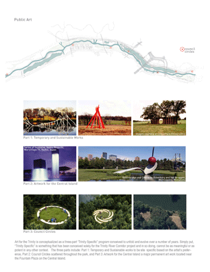
Public Art: Art for the Trinity is conceptualized as a three-part Trinity Specific program conceived to unfold and evolve over a number of years. Simply put, Trinity Specific is something that has been conceived solely for the Trinity River Corridor project and in so doing, cannot be as meaningful or as potent in any other context. The three parts include: Part 1: Temporary and Sustainable works to be site specific based on the artists preference, Part 2: Council Circles scattered throughout the park, and Part 3: Artwork for Central Island a major permanent art work located near the Fountain Plaza on the Central Island. (Photo: Brad Goldberg)
Public Art (Photo: Brad Goldberg)
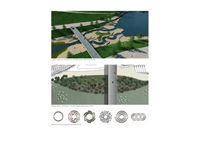
Urban Lake: The Arrival Plaza will host races, performances and boating concessions. A 500-foot long water wall frames the primary access ramp from a deck park over the Parkway. (Photo: Wallace Roberts & Todd, LLC (WRT))
Urban Lake (Photo: Wallace Roberts & Todd, LLC (WRT))
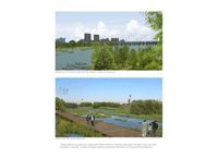
Natural Lake: The Natural Lake, as the name implies, is intended to evoke a naturalistic feeling through soft, riparian edges with a backing of native woodland vegetation. It is also intended as the launching venue for canoeists and kayakers wishing to paddle the four-mile / four-hour Lakes-to-River loop. (Photo: Wallace Roberts & Todd, LLC (WRT))
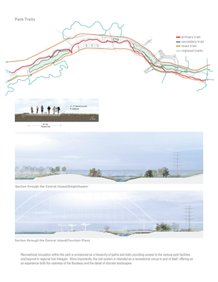
Park Trails: Recreational circulation within the park is envisioned as a hierarchy of paths and trails providing access to the various park facilities and beyond to regional trail linkages. More importantly, the trail system is intended as a recreational venue in and of itself, offering as an experience both the vastness of the floodway and the detail of discrete landscapes. (Photo: Wallace Roberts & Todd, LLC (WRT))
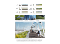
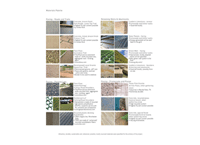
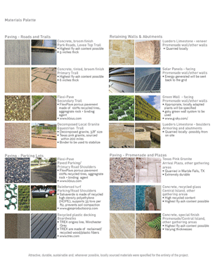
Materials Palette: Attractive, durable, sustainable and, whenever possible, locally sourced materials were specified for the entirety of the project. (Photo: Wallace Roberts & Todd, LLC (WRT))
(Photo: Wallace Roberts & Todd, LLC (WRT))
(Photo: Wallace Roberts & Todd, LLC (WRT))
(Photo: Wallace Roberts & Todd, LLC (WRT))
(Photo: Wallace Roberts & Todd, LLC (WRT))