

«previous pageANALYSIS & PLANNING CATEGORY
Honor Award
The Floyds Fork Greenway Master Plan, Louisville, KY
Wallace Roberts & Todd, LLC, Philadelphia, PA
client: 21st Century Parks, Inc.
Project Statement
The Floyds Fork Greenway Master Plan establishes the general design direction for over 3,200 acres of permanently protected park land on the eastern edge of the Louisville, KY. Visionary in its scope and approach to sustainable design, the plan defines a blueprint to increase biodiversity through habitat preservation and enhancement, improve water quality through innovative stormwater management techniques, preserve agricultural land, and measure the regional sustainability costs and benefits of plan proposals implemented over time.
Project Narrative
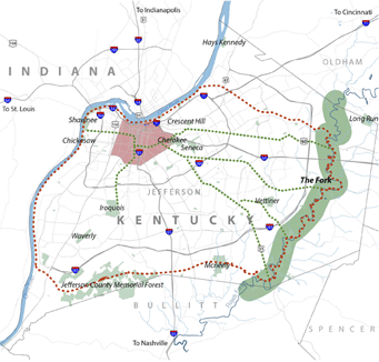
The Fork, also known as Floyds Fork Greenway, is the result of Louisville’s visionary thinkers and city leaders, who, over the course of decades, have been setting aside valuable green space around the beautiful Floyds Fork stream valley in the eastern portion of the Louisville, KY Metro region. With more than 3,200 acres stretched over 19 miles from Shelbyville Road at the north to Bardstown Road at the south, The Fork offers Louisville a unique opportunity to provide for the recreation and open space needs of its emerging communities as development continues its eastward expansion. The sheer size of The Fork, its magnificent views, natural beauty, and unique history places it among the most important urban park development projects in the region — if not the whole country — today.
The Floyds Fork Master Plan provides a framework, or “blueprint”, for the long-term development of The Fork predicated on permanent public access and design excellence. It is based on sound park and planning principles and grounded in the values and aspirations of hundreds of people. Federal and municipal agencies, civic leaders, park and recreation enthusiasts, private non-profit organizations dedicated to land conservation and park building, and the general public participated in an 18-month collaborative planning process to frame a long-term vision for The Fork and lay the groundwork for this master plan.
The process was led by 21st Century Parks, Inc., a Kentucky-based private, non-profit corporation, created to bring a fresh vision to the preservation and development of new public parklands. In partnership with 21st Century Parks are the Future Fund, Inc., a private land trust which is contributing land and easements for public access to privately held lands in The Fork; and the Louisville Metro Parks Department, which is contributing existing city parkland to the project. Together, this unique public/private partnership has assumed the charge of ensuring that the vision for The Fork materializes and that it plays a significant role in the daily lives of all Louisville residents.
Over $62 million has already been raised, bringing The Fork one step closer to reality. To date, over $24 million in private funds has been raised for land acquisition, preservation, and a park maintenance endowment. Another $38 million in federal funds has been procured by U.S. Senator Mitch McConnell to fund the building of roads and trails in The Fork.
Six goals were developed to guide the long-term implementation of The Fork’s proposed trails, environmental enhancements, community parks, and other recreational amenities; and to ensure that The Fork becomes a place of great civic pride for the residents of the entire Louisville Metro region. The goals were developed in conjunction with the 21st Century Parks’ Board of Directors and the consultant team and assert the importance of achieving the desired balance of recreational development and environmental stewardship throughout The Fork. The goals are to:
- Create a remarkable and creative combination of greenways, trails, and parklands of the highest quality standard;
- Provide for conservation of natural resources and for environmental sustainability;
- Foster creation of a well-used and well-loved community resource;
- Create a valuable recreational resource that is welcoming, inclusive, and serves a wide variety of needs and interests;
- Develop facilities for The Fork that are safe, effectively maintained, and economical to operate; and
- Integrate on-going regional planning efforts, surrounding land uses, neighborhoods, proposed private developments, and public infrastructure improvements to create a symbiotic relationship between The Fork and its environs.
When fully constructed, the Fork will be the largest designed park in the Metro area. Larger than Louisville’s famous Olmsted Park system, The Fork’s 3,200 permanently-preserved acres will shape the quality of life for Metro residents well into the future. The sheer magnitude of The Fork is its greatest asset. In the near-term, the basic framework of community parks, trails, and other amenities will be built, providing access and developing focal points of recreational use designed to the highest standard. Over time, as other partners join the effort, many other features and recreational amenities will be designed into The Fork.
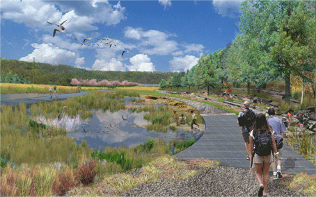
The Fork will also be a place for the pursuit of active and passive recreation. Permanently preserved for the citizens and visitors of the Metro area, The Fork will provide a wide variety of activities such as field sports, jogging, paddling, bird watching, picnicking, and gardening. Activities such as concerts, festivals, balloon launches, and other similar events will enliven eastern Jefferson County. Conveniently accessible parks and gathering places will help create a heart for the county’s growing communities and a new destination for Louisville’s residents and visitors. As the Louisville Metro region grows and adjacent lands develop, The Fork will be central to daily life. The Fork will be a place where people can experience a rich array of recreational and cultural activities, set within a wide range of landscapes that are both comforting and inspiring.
Planning Process
The Master Plan for The Fork has been prepared using an open and transparent planning process that included extensive input from residents of the Louisville Metro region, park and recreation enthusiasts, and a wide range of technical experts. The process consisted of four main phases:
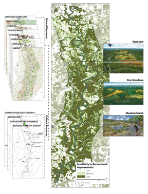
Inventory and Analysis: Background information on natural and cultural resources and other topics relevant to the Floyds Fork stream valley were collected and evaluated. Issues important to the future of the Greenway were identified through analysis of the background information and focus group discussions with persons possessing specific knowledge of or having a stake in the project. The information gathered in the inventory and analysis phase allowed the consultant team to define those areas throughout The Fork that the most sensitive, moderately sensitive, and the least sensitive to recreational improvements.
Conceptual Alternatives: The exploration of various options for trail and park road alignments, the arrangement of recreational features, and natural/cultural resource preservation and enhancement elements were also formulated. Specific trail alignment alternatives, as well as a general direction for the arrangement of other features were presented. A facilitated input session after the presentation allowed the public to evaluate alternatives and express a preferred direction for further development in the next phase.
Master Plan Development and Draft Plan: In this phase, the preferred conceptual alternatives prepared and evaluated in the previous phase were developed further to establish a definitive design direction for the various components of the Greenway.
Final Master Plan: Based on the feedback received on the draft plan from the previous phase, the Master Plan was refined and the final Master Plan was prepared.
Sustainability
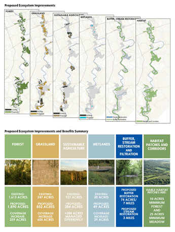
Sustainability, as applied to The Fork, means environmental and cultural stewardship; societal equity through universal access and the provision of diverse recreational amenities; creation of community gathering spaces; and economic stability through viable programming and revenue generating features. All of these sustainable practices have been integrated in the design of The Fork’s parks and special places. Ecosystem improvements that contribute to the environmentally sustainable development of The Fork have also been applied throughout its proposed design. The enhancement of existing and re-establishment of new ecosystems in The Fork represent numerous environmental, economic, and cultural benefits as well, not only for The Fork area, but the entire Louisville Metro region. The types of proposed ecosystem enhancements and their benefits include:
Forest: Increasing the acreage of existing forested areas will improve wildlife habitat, improve water quality and infiltration rates, decrease flash flooding, stabilize slopes, improve air quality, and absorb carbon (a major greenhouse gas). At full implementation, The Fork forest cover will increase from an existing 1,417 acres to 2,022 acres.
Grassland and Meadow: A common ecosystem type found throughout The Fork, grasslands are typically dominated by a few common plant species. Meadows, however, are species rich and support a diverse range of native flora and fauna. The benefits of introducing more meadowlands in The Fork include increased water quality through the filtration of stormwater runoff , increased carbon sequestering, increased wildlife habitat, and reduced maintenance (meadows require minimal mowing). At full implementation, the amount of grassland and meadowland will be increased from 247 to 852 acres.
Sustainable Agriculture: Currently, agriculture is an existing use throughout The Fork. In several areas, agriculture is proposed to remain as part of the productive landscape and as a reminder to Fork visitors of the area’s agricultural heritage. As a viable alternative to traditional agriculture, sustainable agriculture places a greater value on water and soil quality, as well as crop diversification. Though the total agriculture coverage will be reduced from 400 to 318 acres, the integration of sustainable agricultural techniques will greatly improve The Fork’s environmental integrity.
Wetlands: Wetlands offer a wide range of environmental benefits including the enhancement of water quality, reduced flooding, recharged groundwater, and improved habitat for wildlife. Though wetlands occur in small, isolated locations throughout The Fork, an increase in their size and number will further enhance and protect The Fork’s integrity as a natural resource. The proposed increase in wetland acreage ranges from 10 to 54 acres.
Riparian Buffer and Tributary Stream Restoration: Though all the ecosystem improvements described above indirectly impact the quality of Floyds Fork stream, several improvements are proposed that enhance the stream in a more direct way. These include a 300’-wide (minimum) vegetated riparian buffer (totaling 74 acres or 7 linear miles) along the length of Floyds Fork, and the restoration of tributary streams entering it. In addition to enhancing water quality, the riparian buffer and restoration of tributary streams provide valuable habitat for wildlife.
Habitat Patches and Corridors: Viable habitat areas (patches) are defined as 10 acres or more of contiguous forest and 25 acres or more of contiguous meadow. Corridors serve as biological “roadways” that connect patches and encourage the free movement of wildlife among them. Habitat restoration within The Fork will focus on returning degraded habitats to viable ecosystems and development of a continuous wildlife corridor that supports species diversity and the free movement of wildlife to maintain viable breeding populations.
Project Resources
Biohabitats, Inc.
HNTB, Corp
John Milner Associates
Burgess and Niple

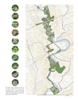
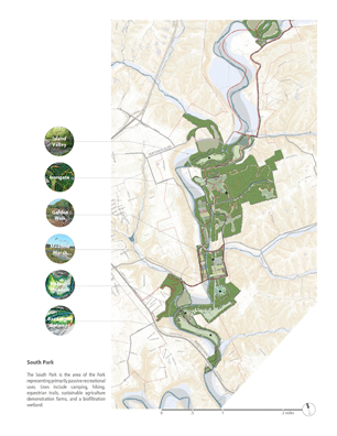
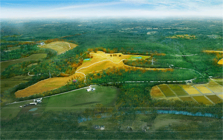
The Master Plan — The Fork is organized into two distinct regional parks, the North Park and South Park, which are comprised of separate landscapes that can be thought of as rooms.

The North Park represents the area of the Fork consisting of the most active recreational uses. These programmed activities include a great lawn, athletic fields, a biofiltration garden and space for performances and festivals.

The South Park is the area of the Fork representing primarily passive recreational uses. Uses include camping, hiking, equestrian trails, sustainable agriculture demonstration farms, and a biofiltration wetland.

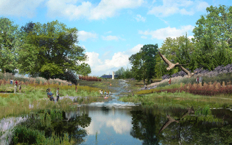
Filter Terraces integrates the operations of treating wastewater at the existing MSD water treatment plant with the Forks experiential qualities. Water gardens will cleanse sewage effluent, demonstrate the importance of environmentally sound wastewater treatment, and provide a striking image of biological processes.

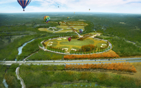
Egg Lawns prominent feature will be an 82-acre great lawn accommodating a variety of programmed activities such as festivals, balloon launches, and outdoor performances. A wide, shady promenade encircles the lawn from which visitors can view lawn activities.

Irongate features three ridgetop meadows occupying the highest points with unique recreation themes including a heritage farm, sledding hill, and remote camping. Other programmed activities include hiking, mountain biking, equestrian trails, observation towers, and food and equipment rental concessions.

Meadow Marsh could accommodate a variety of uses including wetland bio-filtration that removes sediments and pollutants carried by stormwater, an ecofarm demonstrating sustainable agriculture practices, or a heritage farm conveying the storyline of farming in Floyds Fork valley.
"Beautiful scale. Addresses greenbelt for development protection and connects something that will be meaningful. Now is the time to get this stuff right and here is a great example."
— 2009 Professional Awards Jury

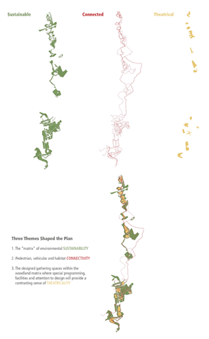
Three Themes Shaped the Plan: 1. The matrix of environmental SUSTAINABILITY; 2. Pedestrian, vehicular and habitat CONNECTIVITY; 3. The designed gathering spaces within the woodland matrix where special programming, facilities and attention to design will provide a contrasting sense of THEATRICALITY.

Inventory of natural and cultural resources enabled the team to identify areas throughout The Fork of low, medium, and high sensitivity to recreational improvements. In turn, this analysis work informed the design of greenway components.

Valuable greenspace is being set aside to provide for the park and open needs of Louisville Metros eastward expanding population.

Proposed Ecosystem Improvements. Proposed Ecosystem Improvements and Benefits Summary

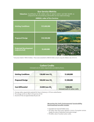
Measuring the Forks Environmental Sustainability Environmental benefits include: Expanded and improved habitat areas; The dollar value those areas represent in terms of ecosystem services (largely the value of bottomland stormwater storage); The dollar value of resultant carbon credits.