|
|
ANALYSIS AND PLANNING EXCELLENCE AWARD
Public Space as Catalyst
for the Regeneration of South Los Angeles
Raphael Garcia, Student ASLA, Sarah Lopez, Student ASLA, Leslie Lum, Student ASLA and Ana Tabuena, Student ASLA
California
State Polytechnic University Pomona, Pomona,
California
Faculty Advisors: Joan H. Woodward, FASLA; Ken McCown, ASLA; Philip N. Pregill, ASLA; Doug Delgado |
|
|
Project Statement:
One billion dollars of investment and fifteen years
after the 1992 civil unrest, South Los (aka South Central)
still remains one of the most disadvantaged areas in
the City of Los Angeles suffering from environmental
pollution, negative public perception, and economic
disinvestment. Today’s favorable political landscape
recognizes that South Los Angeles’ transformation
begins with its public spaces. This project utilizes
a multi-scale, multi-benefit, implementable plan to
spark the regeneration of South Los Angeles.
Project Goals and Objectives:
This graduate project involves a multi-scale
approach to revitalizing a 13-square-mile area of South
Los Angeles designated by the Community Redevelopment
Agency of Los Angeles (CRA/LA) as Council District Nine
Corridors South of the Santa Monica Freeway (CD9 Corridors).
It is adjacent to major transportation corridors and
the historic urban core of the City of Los Angeles.
Within this expanse is a widespread condition that is
emblematic of the rest of South Los Angeles and of many
dense cities in the United States – numerous major
commercial thoroughfares flanked by single and multi-family
homes with concentrations of industrial land that lack
green space and public space. The area suffers from
environmental pollution, negative public perception
and economic disinvestment, which have left their marks
on the physical environment. Environmental pollution,
a by-product of deindustrialization where once thriving
industrial cores have left behind toxic and material
waste, threatens the long-term health and well-being
of the residents that remain. Economic disinvestment,
which began even before the Watts civil unrest in 1965
because of deindustrialization and suburban flight,
intensified further because of the negative public perception
that developed after the Watts civil unrest and the
ensuing April 1992 unrest. In 2003, the City of Los
Angeles changed the area’s official name from
South Central Los Angeles to South Los Angeles in hopes
of erasing negative associations with violence and blight.
At the same time, former Los Angeles mayor Tom Bradley
and former California Governor Pete Wilson organized
Rebuild LA to attract investments into South Los Angeles.
One billion dollars and fifteen years later, South Los
Angeles still remains one of the most disadvantaged
areas in the City of Los Angeles. This is because minimal
attention was paid to the deeper issues that plague
the area. South Los Angeles suffers from an impaired
network of conditions that make prosperity possible.
This network of conditions includes safe streets and
green spaces for children to play. Today, South Los
Angeles is the focus of rebuilding efforts resulting
from a favorable political landscape and numerous developments
occurring throughout its surrounding areas. The majority
of the Project Area falls within the purview of the
Southeast Los Angeles Community Plan, one of thirty-five
geographically-based Community Plans that broadly outline
land use development. The Community Plan is one of the
elements that compose the General Plan, mandated by
the State of California. The General Plan guides the
development of the City of Los Angeles and has not been
comprehensively updated for thirty years. The plan includes
elements such as Open Space, Air Quality and Conservation.
The City of Los Angeles is currently working with the
CRA/LA on updating the Community Plan for this area.
The process includes community meetings to determine
the scope of changes necessary and recommendations for
changes in land use. The revised plan will include ways
of addressing land use inconsistencies and outline how
to proceed with improving the quality of life for South
Los Angeles residents by creating jobs, housing, and
other amenities. Revisions to the plan are scheduled
to be completed in 2009. This offers an opportunity
to revisit the deeper issues that were not addressed
previously. Ensuring that public spaces are built into
the framework of existing and future developments where
community and development interests are balanced offers
a starting point for the area’s regeneration.
The project’s goal is to find public
space opportunities in the CD9 Corridors that will address
environmental pollution, negative public perception,
and economic disinvestment. The project’s primary
objective is to create immediate and tangible evidence
of positive change that can be perceived at multiple
scales. This is carried out by 1) identifying a network
of catalyst demonstration areas in the Project Area
(CD9 Corridors); 2) selecting one of the catalyst areas
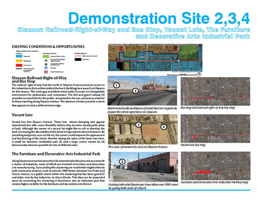
to be the Demonstration Area (Slauson Avenue); and 3)
applying detailed public space strategies to a series
of Demonstration Sites within the Demonstration Area
(Hawkins Park Mixed-Use Neighborhood and the Furniture
and Decorative Arts Industrial Park.) We identified
the following issues and objectives specific to public
space based on the larger issues of environmental pollution,
negative public perception, and economic disinvestment
faced by the Project Area:
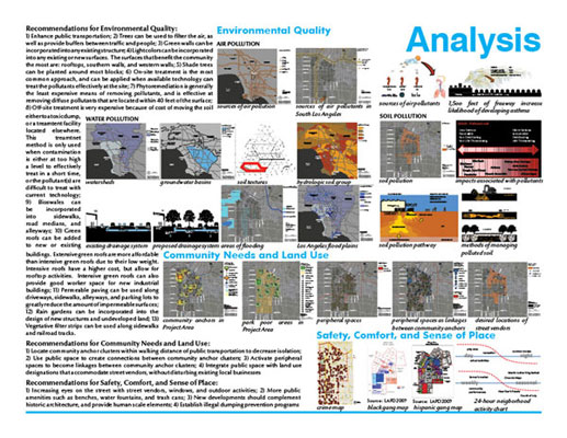
ENVIRONMENTAL QUALITY
|
ISSUE: Polluted air impacts human health. |
OBJECTIVE: Improve air
quality. |
|
ISSUE: Polluted soil
impacts health and threatens safety of water resources. |
OBJECTIVE: Mitigate
soil pollution in public space. |
|
ISSUE: Impermeable surfaces
gather and concentrate pollutants in stormwater,
polluting soils, surface and groundwater resources
and the ocean.
|
OBJECTIVE: Improve surface
water quality
|
|
ISSUE: Impermeable surfaces
convey valuable water resources away from the
landscape, reducing groundwater recharge and water
supply.
|
OBJECTIVE: Intercept
stormwater before it enters storm drains by increasing
permeable surfaces. |
|
ISSUE: Impermeable surfaces and existing stormwater
infrastructure increase potential flood hazards
in South Los Angeles, and further downstream in
the watershed, threatening public safety and property.
|
OBJECTIVE: Increase
permeable surfaces to enhance stormwater infiltration
and reduce the risk of flooding.
|
COMMUNITY NEEDS AND LAND USE
| ISSUE:
Isolation weakens community anchors. |
OBJECTIVE:
Create public space connections between community
anchors. |
| ISSUE:
Residents of South Los Angeles are underserved
by existing park space. |
OBJECTIVE:
Provide spaces where typical park activities can
occur. |
| ISSUE:
Peripheral spaces (vacant lots, alleys, and railroad
right-of-ways) are underutilized and are not integrated
into public space.
|
OBJECTIVE:
Integrate peripheral spaces into current public
space.
|
| ISSUE:
Street vendors, valued by the community, lack
legal locations for their activities. |
OBJECTIVE:
Accommodate physical requirements of impromptu
street vending. |
SAFETY, COMFORT,
AND SENSE OF PLACE
|
ISSUE:
Crime and perception of crime deter use of public
space. |
OBJECTIVE:
Increase use of public space throughout the day. |
|
ISSUE:
Graffiti contributes to an impression of an unsafe
environment. |
OBJECTIVE:
Discourage graffiti. |
|
ISSUE:
Trash demonstrates poor maintenance and contributes
to health hazards.
|
OBJECTIVE:
Deter illegal dumping in public space. |
|
ISSUE:
Blank walls and metal barriers contribute to an
impression of a fortified and unsafe environment.
|
OBJECTIVE:
Create more human scaled environments by reducing
blank walls and metal barriers. |
|
ISSUE:
Streetscapes lack identity and are physically
uncomfortable and visually bleak.
|
OBJECTIVE:
Create streetscapes that provide a sense of identity
and are physically comfortable and visually engaging. |
KINDS OF ENVIRONMENTAL AND SOCIAL
DATA COLLECTED AND ANALYZED
Project Area-scale data included: information on
council district political boundaries, community planning
areas, a sampling of current development projects and
initiatives in the Project Area and in adjacent downtown
Los Angeles, demographic and economic information from
the 2000 U.S. Census, sources of air pollution for the
region from the South Coast Air Quality Management District
(SCAQMD) 2006 Report, transportation corridors from
the Los Angeles County Metropolitan Transit Authority,
identified toxic sites and soil pollution data from
an interview with the Department of Toxic Substance
Control of the State of California and its 2007 Envirostar
Database, land use maps, watershed maps, groundwater
basins map, soil textures, and hydrologic soil groups
from the Natural Resources Conservation Service, Los
Angeles flood plains and areas of flooding from the
2007 Federal Emergency Management Agency, crime and
gang territory maps from the Los Angeles Police Department,
maps showing locations of underutilized peripheral spaces,
community anchors, including existing parks came from
the CRA/LA. Data for both the Demonstration Area-scale
and Demonstration Sites-scale included information on
potential incompatible land use, transportation circulation,
locations of existing community anchors, development
interests, and peripheral spaces from the CRA/LA, the
2007 City of Los Angeles Survey and Mapping Division,
and the County of Los Angeles GIS Mapping. A map also
shows the City-designated Furniture and Decorative Arts
District, which encompasses most of the Demonstration
Area. Data on the existing stormwater management system
was also utilized at the Demonstration Site-scale.
Numerous site visits and interviews with local residents,
non-profits, community groups, and city officials from
the Los Angeles Police Department and the Department
of City Planning informed our project at every scale.
METHODS OF ANALYSIS
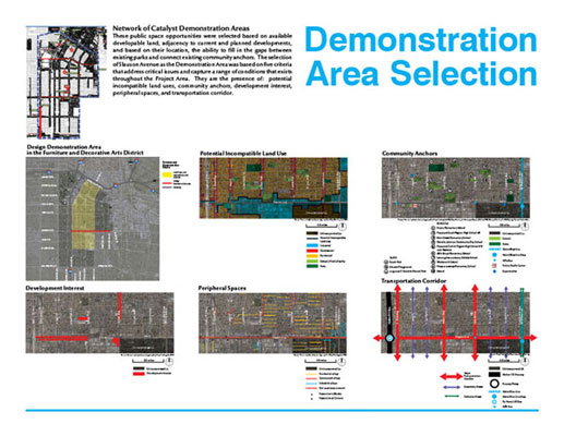
At the Project Area-scale, analysis focused on identifying
catalyst demonstration areas that will spark the formation
of a denser network of public spaces throughout an urban
expanse that does not have an identifiable center.
Demonstration Area-scale analysis considered one of
the most heavily-used corridors, Slauson Avenue, a main
east-west connector through South Los Angeles, which
when developed can showcase immediate and tangible results
that renewal is underway. Demonstration Sites-scale
analysis focused on public space strategies that can
be applied throughout the Project Area. This included
analysis of urban heat island effect and strategies
for mitigation, information regarding the planting densities
of trees to cool the air, pollutants of concern and
allowable pathways, methods for managing polluted soil,
stormwater best management practice, the best clustering
of community anchors, physical requirements and activities
of impromptu street vending, and highlighting the importance
of existing industry, which can provide a positive identity
for the area.
HOW OPTIONS WERE CONSIDERED
At the Project Area-scale, catalyst demonstration
areas were selected based on available developable land,
adjacency to current and planned developments, and based
on their location, the ability to fill in the gaps between
existing parks and connect existing community anchors.
The selection of Slauson Avenue as the Demonstration
Area was based on five criteria that address critical
issues and capture a range of conditions that exists
throughout the Project Area. They are the presence
of: potential incompatible land uses, community anchors,
development interest, peripheral spaces, and transportation
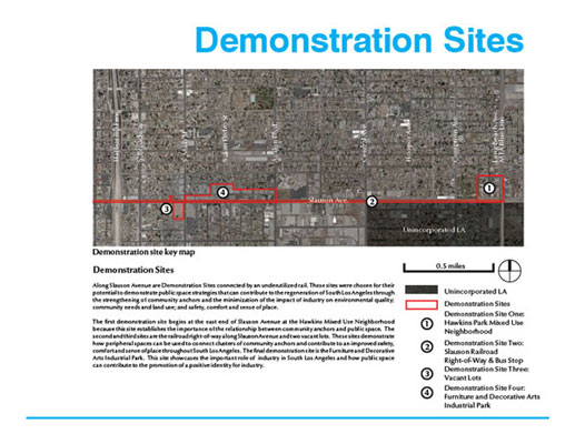
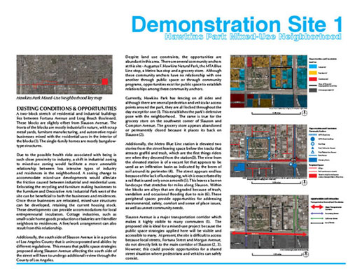
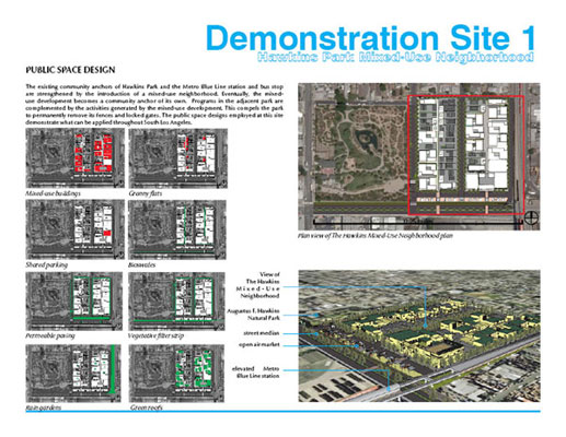
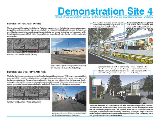
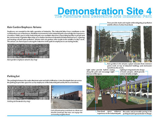
corridor. The Demonstration Sites of Hawkins Park Mixed-Use
Neighborhood and the Furniture and Decorative Arts Industrial
Park reinforced the idea of clustering community anchors
and providing a positive identity for South Los Angeles.
Additionally, specific public space strategies applied
at the Demonstration Sites-scale can be employed in
other Demonstration Areas with additional analysis for
site-specific concerns.
HOW INTERESTED PARTIES WERE INVOLVED
WITH THE PROJECT
The success of this project requires the on-going
participation and collaboration of many players. During
the project our team and our client, the CRA/LA, have
engaged the participation of a diverse group of stakeholders
that included the following concerned individuals, non-profits,
community groups, grassroots organizations involved
with the community, and government agencies: City of
Los Angeles Department of City Planning, Department
of Toxic Substance Control, Los Angeles Police Department,
Neighborhood Councils, and Strategic Actions for a Just
Economy, a non-profit concerned with economic justice
and gentrification issues. Meetings and workshops were
also held with parents and children to obtain first-hand
accounts of current activities in public spaces and
changes they wish to see in their neighborhoods. Presentations
were also made to the Community Advisory Committee.
To date, the graduate project has been used to obtain
various funding for public health, housing, and additional
public spaces for the CD9 Corridors and presentations
have been made using elements from the project to the
Board of Commissioners of the CRA/LA. In addition,
one member of the student graduate team continues to
work with the CRA/LA in providing additional public
space designs for the rest of the Demonstration Area
catalyst sites.
HOW DESIGN WAS USED IN THE PROCESS
Design at the Demonstration Area-scale of Slauson
Avenue focused on connecting development occurring or
planned in adjacent areas, and strengthening existing
community anchors of public transportation, schools,
parks, and grocery stores. The design also provided
a platform to showcase positive aspects of South Los
Angeles that currently is not apparent, such as its
Furniture and Decorative Arts District. Proposed development
of Hawkins Mixed-Used Neighborhood and the Furniture
and Decorative Arts Industrial Park can work together
to support each other and adjacent planned developments.
Site-scale design considered existing stormwater management
system, and existing site opportunities and constraints
to create multi-benefit public spaces. Cumulatively,
design strategies used along the Demonstration Area
of Slauson Avenue and the Demonstration Sites can impact
the rest of the Project Area because the issues are
interconnected and addressing one issue affects another.
HOW THE PROJECT WOULD BE IMPLEMENTED
Because of the decentralized physical nature
of the Project Area, catalyst Demonstration Areas should
be developed as land and funding becomes available for
that particular Demonstration Area. At the Demonstration
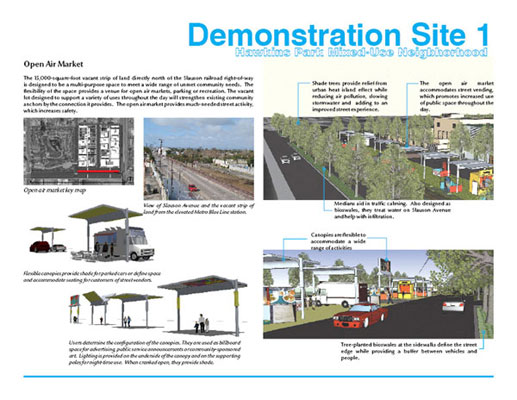
Area-scale, establishing the open air market for the
Hawkins Park Mixed-Use Neighborhood would be a relatively
easy initial intervention to an area that is already
supported by a variety of land uses, a well-used Metro
rail stop, a nature park, and a grocery store. Later
the actual mixed-use neighborhood can be established.
At the Furniture and Decorative Arts Industrial Park,
related businesses can be given incentives to relocate
there as land becomes available, until eventually a
cluster of these types of businesses can create a well-recognized
industrial park that showcases local furniture and decorative
arts talent. Later a partnership can be made between
the industrial park and schools through youth training
and employment, thus strengthening existing and new
community anchors.
HOW THE PROJECT WILL BE ADMINISTERED
AND/OR MONITORED
Vital to the project's administration is laying
out the groundwork for implementation. The expertise
and drive of key players are crucial. This gives energy
to the project, sustaining it through obstacles it may
encounter in the process of realization. The first
step is community engagement at the outset. Next is
collaboration among multiple levels of government and
grassroots/community organizations. Employing traditional
and innovative funding strategies can further aid in
administration of the project. Lastly, demonstration
projects can aid administration of the plan by instilling
the project vision in the public's mind winning support
and additional funding for the rest of the project.
Based on Everett Rogers' Diffusion of Innovation,
demonstration projects should possess the following
characteristics to increase the likelihood of the idea
to spread throughout the Project Area: 1) Relative
Advantage - if an idea is shown to be more beneficial
than previous ideas, then it will be more likely to
be embraced by potential users; 2) Trialibility - the
rate of acceptance of an idea can be influenced by trying
out the idea in a controlled setting, such as in a test
site; 3) Observability - if potential users can see
the idea at work, they are more likely to accept the
idea; 4) Compatibility with Existing Methods - the public's
familiarity with an innovative method contributes to
a favorable response to that innovation; and 5) Complexity
- acceptance of new ideas is impeded if potential users
view obstacles in taking on the new ideas.
|