Project Statement:
emergeMUMBAI addresses flooding at a regional
level, water management and public social spaces for
housing redevelopment sites, and most importantly, it
alleviates the insufficient water supply for the individual
citizen. The project uses modern techniques combined
with Indian models to provide solutions that work within
Mumbai’s culture and maintenance/implementation
regimes. Each block of the colony becomes self-contained
in terms of water management, while supplying enough
water to meet its consumption demands.
Project Narrative:
Mumbai’s biggest problem is its
distribution, control and protection of water. emergeMUMBAI
combines rediscovered technology of urban rainwater
harvesting, with successful Indian models for water
consumption and development. It is a flood mitigation
tool and water supply system that can be implemented
on an individual, housing block or district level.
The greatest issue the urban center of
Mumbai is currently facing is the supply, distribution
and protection of water throughout the city. Mumbai
has the densest population worldwide, reaching a population
over 14 million people. 8 million of these people don’t
have running water. 10% of the population waits over
10 hours for clean water. On a daily basis, Mumbai meets
only 84% of its water demand and yet the city is likely
to increase its population in the next ten years to
over 20 million.
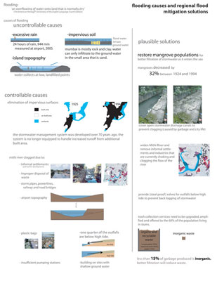
Ironically, three months out of the year,
rainwater is in excess, flooding and backing up into
much of the city and suburbs. With a storm water system
over 100 years old and in desperate need of replacement
or repair, the flooded streets and city fabric shut
down the city annually creating disruption to transportation,
businesses and causing loss of life. This is a result
of poor and unplanned development, a lack of updated
infrastructure, and waste collection systems that are
inadequate to account for the growing population.
Drastic development has increased impervious
surfaces and excess trash and sewage are blocking open
canals, rivers and streams used to drain storm water
out of the city during monsoons. Currently 60% of the
Mumbai population lives in slums where the population
does not have clean running water or reliable access
to toilets. Mothers wash their young families in the
street near water standpipes or from water buckets,
children swim near trash-covered polluted beaches. In
short, access to the basic amenity of clean available
water for this population is minimal at best. These
two issues, flooding and access to clean water, negatively
effect the entire population of Mumbai, putting over
half of them at serious health risk.
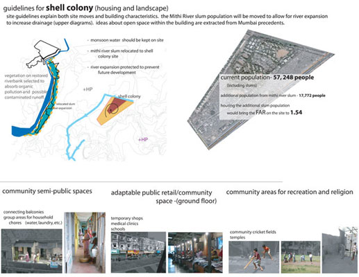
Mumbai, however is currently going through
major redevelopment as a global financial and technology
center, focused on rebuilding and densifying the public
housing areas and the slums. Now is the appropriate
time to rethink the water systems of the city, and their
relationship to flooding.
The project, although site specific, is
a model for public housing developments as well as other
municipal and private developments and initiatives.
Many of these low-rise sites are being redeveloped into
towers, maintaining the current population, but providing
additional apartments to address the needs of the growing
population. Towers do not adequately address flooding
and they disregard many successful aspects of Mumbai’s
current housing such as semi public balcony space and
protected open green spaces. Importantly, the new proposals
fail to acknowledge the importance of the street in
everyday life, whether as a venue for retail, religious
practices, social activity, eating, and family life.
The combination of failing infrastructure, the growing,
unmet demand for clean water, and an opportunity for
easily implementing change, makes Mumbai a key location
for this creative yet practical initiative.
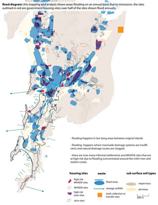
regional. emergeMUMBAI
started by creating the first ever map of flood points
in greater Mumbai. This investigation of where and why
the flooding occurs led to regional solutions the city
could use. This analysis determined the location of
high-risk sites, including government housing sites
possibly up for redevelopment. The investigation continued
by focusing on one critical, 100-acre site. Located
close to the Mithi River, the site is able to accommodate
for the proposed redevelopment population, surrounding
slums, and relocation of a slum along the Mithi river.
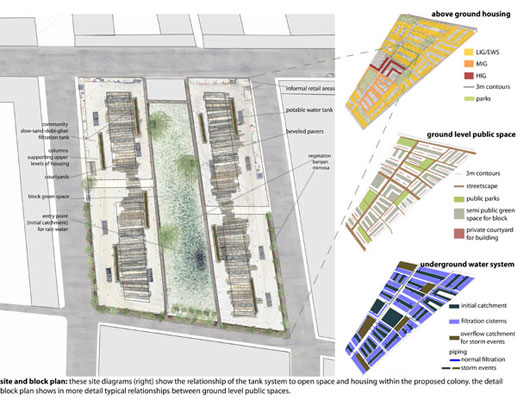
site. The strategy creates
a site that maintains and uses all rainwater on site,
while taking into consideration spatial and cultural
issues for Mumbai’s water use and city life. The
plan is shown on three levels: underground water system,
ground floor public spaces, and above ground housing.
Research proved that, despite the government’s
beliefs, the underground tank system would need to be
more elaborate than sub-building tanks. The underground
master plan shows initial catchments and over flow tanks
below open space, providing easier maintenance. Water
flows by gravity and can be held underground on-site,
until filtered and used.
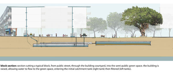
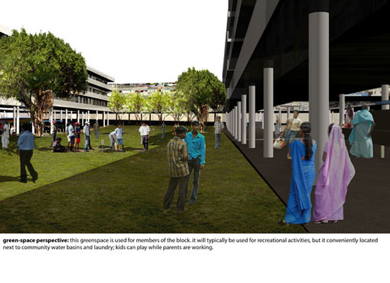
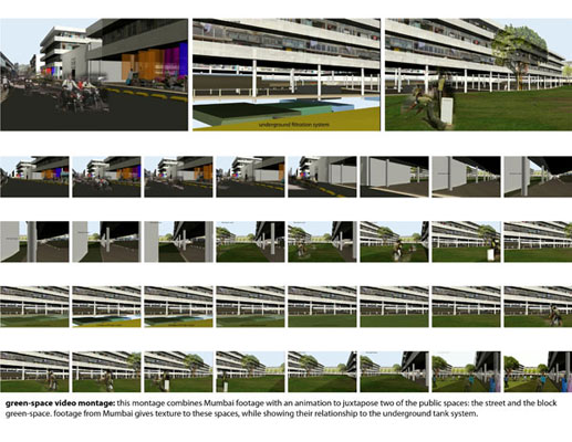
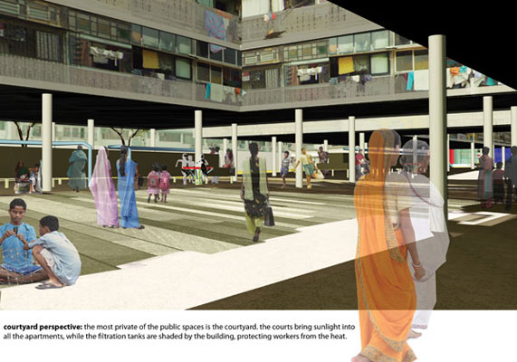
block. The master plan
features four types of public spaces. Main streets are
the most public of the spaces, followed by five large
parks. Each block has green space for recreation while
buildings have smaller courtyards for tenants. The ground
floor of each building, on the public street side, is
used for temporary or informal retail, religion and
gathering space. Private areas are used for storing
and gathering water, community chores, and activities.
The relationships between public/private spaces and
housing, circulation and main streets were determined
with regards to program.
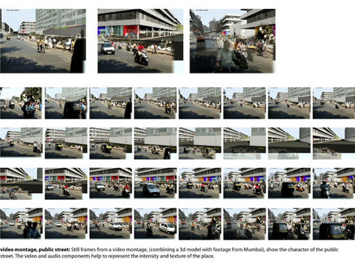
Video montages clearly demonstrate the
spatial implications of the proposal on the intense
population, use and activity in Mumbai. Mumbai is a
city, which wants to be cosmopolitan, and to a certain
extent is. However, the populations of these sites are
unable to progress past traditional living methods.
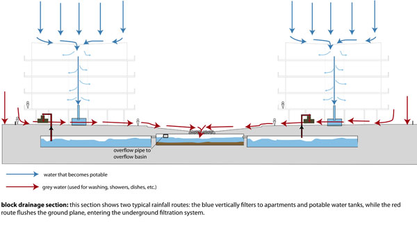
detailed water movement.
The concept of ablution- using water to cleanse oneself
- is important in many religions practiced in Mumbai.
This concept of flushing is brought to the redevelopment
plan. Instead of the monsoons being a perennial problem,
this system uses the monsoons as a cleansing of the
land, flushing each block. During the monsoons, the
water moves through the ground story of the block (the
building is elevated on columns), and into the underground
filtration system. Water from the roof vertically filters
to become potable and is stored at ground level.
An axonometric shows the specific water
movement through one filtration route. Water moves through
a settling tank, flocculation and coagulation, and several
filters, until a play pump brings water to ground level
where it flows through the slow-sand-dobi-ghat filtration
tank (the system I designed is a filtration tank, paired
with usage bins, derived from a modern Indian laundry
system). The end result here is grey water, but is clean
enough for laundry and bathing.
|