Project Statement
The Lower Howard’s Creek Corridor
Management Plan is the first comprehensive management
plan of its type in the region. Careful planning and
analysis was needed, not to construct new features,
but to determine how this important landscape should
be protected. This project uncovered the multi-layered
stories of the Lower Howard’s Creek landscape,
and developed protection and interpretive strategies
to allow the landscape to continue to depict those well
stories into the future.
Narrative Summary:
A Great Challenge in landscape
planning and analysis is to maintain an empathetic connection
to landscape, while conducting a defensible analysis
that supports logical decision making. The consultants
and clients for the Lower Howard’s Creek Corridor
Management Plan met that challenge by combining a narrative
description of cognitive landscape districts with thorough
documentation of cultural and natural resources, and
explicit methods for evaluating resource significance
to make planning decisions. The plan and accompanying
report communicate effectively with a lay audience of
citizens, property owners, and local public officials,
and make a defensible case for funding to state and
federal environmental agencies.
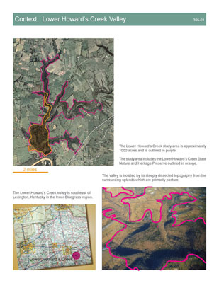
The Lower Howard’s
Creek Valley is located at the edge of
the Inner Bluegrass Region of Kentucky. The creek itself
is a short stream and cuts a deep gorge from the Bluegrass
uplands to the Kentucky River. The valley is part of
an ecological sub-region within the Inner Bluegrass
known as the Kentucky River Palisades and Tributary
Gorges. The palisades landscape is the major remnant
of native forest in the Inner Bluegrass and the varied
topographic forms of the Lower Howard’s Creek
valley support a diverse group of plant communities
that include several endangered or threatened species.
This is in sharp contrast with the rest of the region,
which is intensively managed for livestock agriculture.
Lower Howard’s Creek
played a significant role in the early settlement of
the trans-Allegheny frontier. Across the Kentucky River
from the Boonesborough settlement, it was the first
creek populated by millers harnessing water power when
they moved out of Boonesborough’s fortifications.
The valley is also emblematic
of African-American experience in Central Kentucky.
Enslaved Africans built and worked in many of the valley’s
industrial and agricultural enterprises. Freed families
remained after emancipation, first as employees of landowners
and later as subsistence farmers who supported themselves
with employment outside the valley. The community of
freed men and women centered around the Old Stone Church,
formerly the home of a white congregation in which Daniel
and Rebecca Boone’s children were baptized. By
the late twentieth century, the valley was mostly unoccupied
as residents abandoned Lower Howard’s Creek for
employment opportunities elsewhere.
The valley today is mostly
covered in early and mid-succession woodlands. Palisades,
waterfalls, sinkholes, and other geologic formations
are dramatic evidence of erosion as a sculptor of topography.
Cultural features include at least six mill complexes,
abandoned but intact stone houses, the stone church,
the ruins of a distillery and other industrial enterprises,
numerous house ruins, rock quarries, and an extensive
network of pioneer roads and rock fences. Part of the
valley is protected as the Lower Howard’s Creek
State Nature Preserve, but most land remains in private
ownership.
Project Goals
This landscape of national cultural significance and
regional biological importance is barely known within
its own local area. The consulting team was charged
to build on previous documentation to thoroughly explore
and describe the relationships between cultural and
natural resource features of the valley, to analyze
their relative significance, and to propose long-term
plans for preservation and public access. Specific goals
included:
- To catalog undocumented cultural
and natural resources;
- To make sense of landscape patterns
and hundreds of point features by emphasizing their
relationships within a complete landscape pattern;
- To prioritize areas for legal
protection through conservation easements, acquisition,
or other means; and
- To design a conceptual plan
for visitor access and interpretation, emphasizing
a vision for future experience and linked to biological
protection and cultural resource preservation.
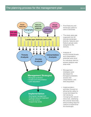
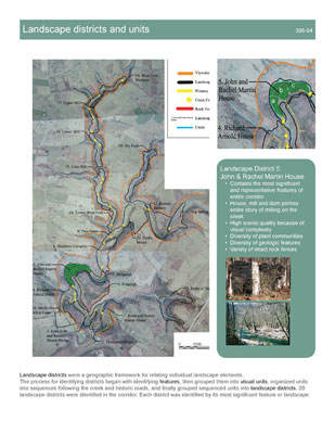
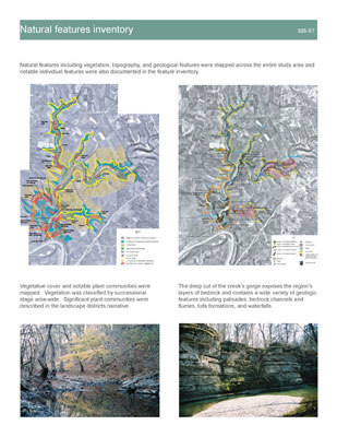
The Inventory was
significant for the depth of understanding developed
and communicated in the plan. Archeological survey,
historic documentation, natural features inventory,
and visual character assessment were individually engaged,
but also described holistically in a landscape narrative.
The narrative linking these resource types together
describes a cognitive system for comprehending the complexity
of the resource-rich Lower Howard’s Creek Valley
by shaping a mental geography of 20 landscape districts.
Each district is centered around a predominant cultural
or natural resource complex. Each district is further
described as composed of one or more landscape units,
each having a clear spatial identity.
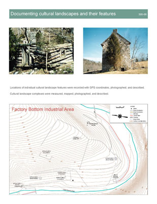
- Archeological features and their
sites were located precisely by GPS coordinates, photographed,
measured, described, and assessed for condition in
the field. Historic documentary research using primary
and secondary sources was used to link sites to people,
times, economic patterns, and folkways, leading to
later development of interpretive themes and evaluation
of significance.
- Biological resource documentation
benefited from existing studies, including those conducted
by the Kentucky State Nature Preserves Commission
and Joe Kendall Neel’s fascinating 1938 thesis
from the University of Kentucky Biology Department.
Parallel work to inventory all vascular plant species
in the publicly owned portion of the valley was underway
at the time of the project. A macro-scale plant community
inventory was conducted by the consultants based on
reconnaissance from a small plane and the ground.
- Geological features were inventoried
with emphasis on visual prominence and ability to
explain regional geologic characteristics.
- Visual character was documented
and assessed using a descriptive system modified from
Steven and Rachel Kaplan’s theoretical work
Cognition and Environment: Functioning in an Uncertain
World. This method emphasized visual legibility and
complexity, which related well to the geographic division
of the valley into connected landscape districts and
units.
- Land use conditions and potential
conflicts with resource conservation were surveyed
and documented with emphasis on farming practices
and scattered rural residential development on adjacent
uplands.
- Terrain presented extreme access
challenges in a narrow valley landscape whose roads
were last used before automobiles existed and where
the main wagon road crossed the creek 14 times in
three miles. Slope conditions were mapped, historic
stream crossings and potential alternates evaluated,
and alternate overland routes were explored to provide
information for the design of access routes for visitors
and for equipment needed for structure preservation.
The project’s approach to
data gathering was based on careful observation, an
ethic of stewardship, and a sense of landscape not as
abstract areas, but as the spatial expression of natural
and cultural history. The involvement of the landscape
architects in the field work led directly to the design
of meaningful visitor experiences and to the protection
of smaller scale individual features unlikely to be
understood in a broad-scale, categorical landscape inventory
and analysis.
Involvement of Interested
Parties occurred throughout the project
to inform the process about the landscape, and cultural
and natural features of the valley. Involvement went
well beyond the traditional large public presentation
format. Local residents led team members on tours, shared
the folklore of the valley, and described features and
locations that were most important to them. Small group
meetings with individual landowners were found to be
productive because future plans for ownership changes,
conservation easements, and other property issues could
be discussed more openly than in a public forum. The
Friends of Lower Howard’s Creek, which represented
the community and the county government as client, was
actively and critically engaged in the development and
review of the plan for the valley. Reporting to the
community as a whole has extended beyond the planning
and design phase as members of the design team and stakeholders
have delivered public talks at the local library and
museum to keep the valley in the public eye.
Analysis
A readable explanation of the inventory was linked with
a rigorously explicit analysis process that considered
cultural resource preservation, biological protection,
and the ability of resources and districts to communicate
interpretive themes.
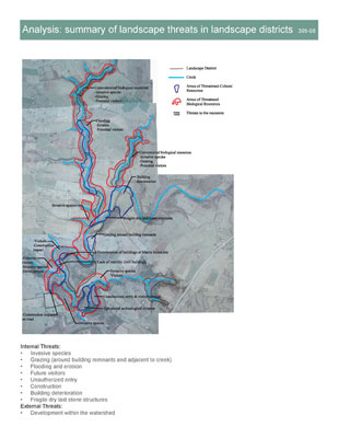
Threats to biological and cultural
resources were assessed early, based on a combination
of the fragility of the resource and the intensity of
the threat. Farming and grazing practices, erosion,
invasive plant species, and the potential for damage
by future visitors were all incorporated into the threats
assessment.
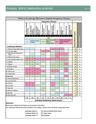
Interpretive themes were developed
as part of the inventory and were based on the cultural
and economic themes revealed by historic documentation
and on an understanding of the biological, geological,
and visual resources and their relationship to regional
geography.
An access and barriers analysis
evaluated different schemes for providing trail and
work vehicle access to the valley. In each scheme, the
ability to ford the creek at 14 different points and
the potential expense and intrusiveness of bridges were
balanced against the potential for trails on valley
slopes, and the interpretive importance of using the
old rock fence-lined roads that traversed the valley
through homesteads, industrial sites, and quarries.
Visual analysis ranked
districts according to the density and balance of features
that contribute to both visual complexity and visual
legibility. This ranking was based on a rationale that
in districts where visitors would be simultaneously
most intrigued and most oriented, they could develop
a more vivid understanding of the landscape’s
cultural history and ecological dynamic.
The Design Proposal
focused on weaving visitors through the valley and into
the very most intriguing places, while teaching them
about its natural and cultural history. This experience
was designed to avoid impact to biological resources
and it influenced choices about which cultural resources
would be merely stabilized and which would receive more
intensive preservation action. The intent, after all,
was to design an experience within a place that already
has its own genius and to only minimally change that
place.
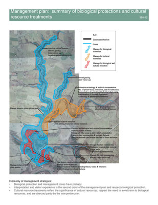
Biological resource protection
strategies included monitoring listed species and unusual
plant communities, protection of additional areas from
grazing, differentiating appropriate levels of visitor
use in different parts of the valley, eradication of
invasive exotic species, and selective management of
certain areas as cultural landscapes.
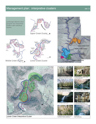
Four interpretive experience clusters
were designed, each with an emphasis on a different
aspect of the valley landscape and each intended to
occupy a half-day’s time. The clusters were made
up of landscape districts that when grouped together
could most clearly communicate a group of interpretive
themes and that could be linked with a coherent sequence
of paths, usually on historic roads. Management regimes
in each cluster include natural succession, maintenance
of domestic yard clearings, active preservation of cultural
resources, and other strategies. Each cluster includes
one district where a cultural feature can serve to concentrate
and focus interpretation around a physical structure:
a new visitor center in one cluster, preserved stone
houses in two others, and the preserved archeological
remains of a settlement in the fourth cluster.
Cultural resource intervention
is perhaps the most costly effort associated with the
corridor management plan, and it has been phased over
many years according to priorities ordered by the immediate
need to stabilize a feature, the interpretive role of
a feature, and the appropriateness of a particular intervention
within the environmental context of a landscape unit
and district.
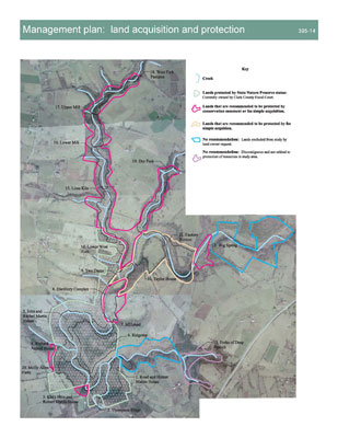
Land protection and acquisition objectives,
wider scale land use and watershed planning, and future
resource documentation are all prioritized within the
plan so that local advocates and governmental bodies
have clear directions for action over a long period
of time and are not left to sort out a sequence of appropriate
actions.
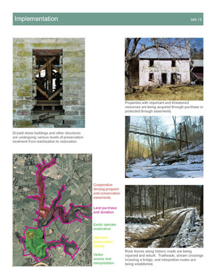
Implementation
of all aspects of the plan will take decades. Significant
steps have already ingrained the plan into the landscape.
An active volunteer invasive species removal program
is in place. One large property has been purchased and
incorporated into the existing State Nature Preserve.
Rock fences have been rebuilt along historic roads.
A suspension foot bridge was built over a key creek
crossing. Trails connecting historic roadbeds have been
marked and cleared. A key stone house has been stabilized
and documented, and is now undergoing a more intensive
preservation treatment. Public funding is being used
to fence cattle out of fragile areas on public and private
property with the cooperation of landowners.
Monitoring
of the valley and its resources is an ongoing activity
of the Kentucky State Nature Preserves Commission, Clark
County government and the Friends of Lower Howard’s
Creek, a non-profit advocacy group. All three groups
have an active interest in the valley and its well-being.
Additionally, researchers from Eastern Kentucky University
and the University of Kentucky continue to monitor the
ecological resources in the valley.
In summary,
possibly the most important aspect of this plan is that
a diverse set of interests have found common ground
in a well-expressed vision for the future of the valley.
The vision has the flexibility to accommodate future
directions, while being based on sound analysis and
a thoughtful sense of the wholeness of landscape.
|