This design explores how time, entropy and indeterminacy can be
used to design a marginalized urban space. Specifically, the project targets the condition of border and migration
between Mexico and the United States. How can the border be designed as a fluctuating space, and how can this
fluctuation approach the condition of migration?
History and Context: The Expanding US-Mexico Border
In the past 150 years, the US--Mexico border has changed from an invisible and unmapped line into a 2,500 mile
frontier region with a unique set of economic, social, and spatial conditions. Perhaps the most remarkable
phenomena are the exponential growth of twin cities along the border, and the thickening and expansion of
the border itself. Border cities, such as El Paso and Ciudad Juarez, are linked together by an intricate network
of global economic forces, yet they are physically and politically separated. Habitation within these cities
is often improvisational as infrastructures cannot keep pace with the steady influx of more people.
In spite of the North American Free Trade Agreement (NAFTA, 1992), which has allowed for the relatively
free flow of goods and services between the two nations, the border -barrier has become more pronounced. The
United States in particular has attempted to deter undocumented/illegal
immigration through policies such as “Operation Hold-The-Line” between El Paso, Texas and Juarez,
Mexico. This policy has added multiple layers of chain-link fences, floodlights and armed surveillance to the border,
thus increasing the width of the border and creating a “no-man’s land” , or third entity
between the two cities. The border space between Juarez and El Paso is both urban void and terrain vague. People
meander through the space and there are very few built structures. Aerial photographs confirm the presence
of a large expanse between the two cities that is a direct result of changes and fluctuations in the border.
As it has become harder to cross the US-Mexico border near border towns, undocumented migrants have
been forced to cross in the open desert, where many die from heat exhaustion, exposure, hypothermia, dehydration.
In 2004, nearly 400 migrants were estimated to have died trying to cross the border.
The Next Fluctuation: Ephemeral Occupations
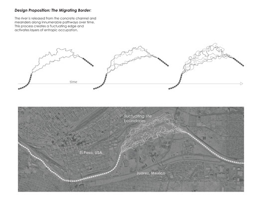
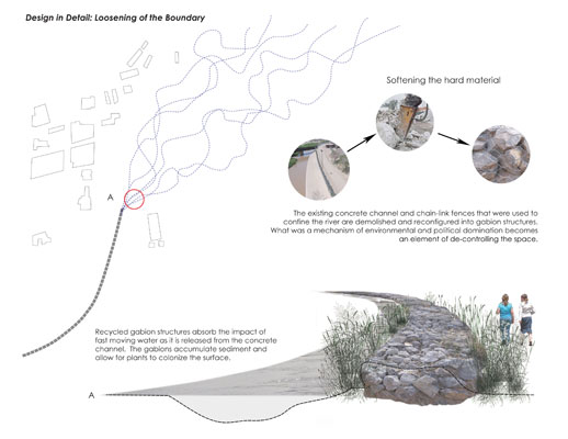
In a 1962 agreement between the United States and Mexico, the river border between Juarez
and El Paso was moved and stabilized within a concrete channel. This change left a void in the urban fabric
between Juarez and El Paso that still exists today.
This design proposal utilizes the urban void created
by historical shifts of the border between Juarez and El Paso as an opportunity to redesign the border as
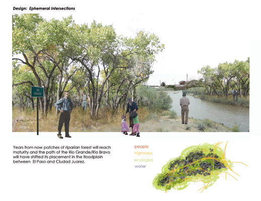
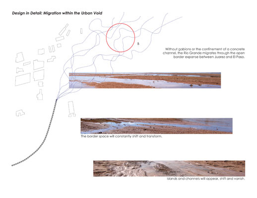
a fluctuating, indeterminate space. This process begins by releasing the Rio Grande (the border by treaty definition)
from the concrete channel, thus allowing flows of the river to meander through the floodplain, constantly
changing the precise location and thickness of the border. Through time (daily, seasonal, and mechanistic) the
river shifts, migrates, floods and runs dry, and these processes create entire spaces of migration in which
all elements—the ground plane, ecologies, and human occupation are transitional and constantly changing.
What the border is one day is different
from what it may be tomorrow. The space becomes a series
of momentary events in constant flux that will never
repeat in the exact same way.
Inundations
Water
Water fluctuation through the space is controlled through
the existing array of upstream infrastructures that
include a series of dams, reservoirs and diversion channels.
Additionally, the space serves as a massive retention
basin for storm events, enabling run-off from the expanding
twin cities of El Paso and Juarez to collect at the
topological seam between them. One day the river is
a gentle stream…calm, tranquil, and the next it
is a torrent as powerful as the economic shifts that
cause people to migrate.
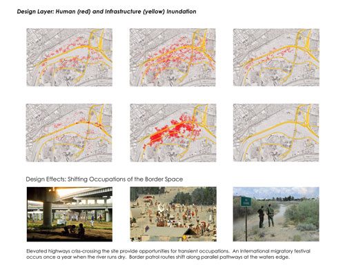
Occupation
Human occupation of the border will vary with the processes
of the river and the ecologies that emerge. Border patrols
are saved from boredom by the necessity of shifting
the ground they patrol depending upon the shifting width
of the border space. When the river runs dry, the edge
disappears all-together and people can exit and enter
the border space at will. The seam is closed and the
abstraction of the line is revealed through its disappearance.
At these times international festivals occur on the
border ‘island’ that flood the space with
people from all over the world. The border is alive,
improvised, irreverent, and jubilant.
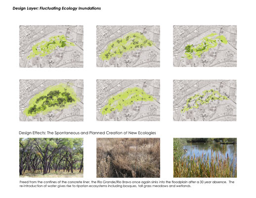
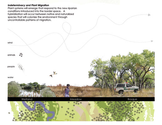
Emergent/Divergent Ecologies
The Rio Grande/Rio Bravo is a polluted and dying river.
Strictly regulated flows and concrete channels engineered
in the 1960s have eliminated much of the riparian habitat
along its banks. Industries on both sides of the border
dump heavy metals, and runoff from irrigated fields
increases the alkalinity of the water.
If the Rio Grande is released from
the concrete channel, it will once again penetrate into
the ground, and create a diversity of habitats, such
as bosques, meadows and wetlands that will begin to
reclaim the river through regenerative natural processes.
These environments will emerge and migrate with the
fluctuations of the river, creating places that are
never the same.
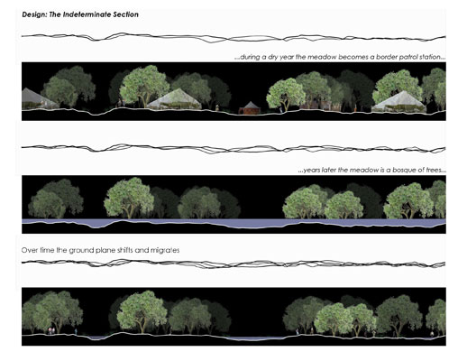
Indeterminacy and Time
As the river shifts courses, an abandoned channel becomes
a tall grass meadow where a migrant spends the nigh,
and the next day the river floods and the meadow lies
beneath the swiftly moving current. During a particularly
dry year, the space becomes part of the oscillating
border patrol pathways. Years later, riparian trees
have reached maturity and the meadow becomes a shady
bosque.
|