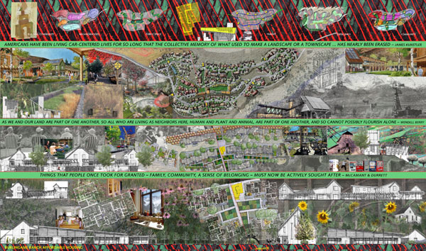
In 2000, the City of Aspen adopted the Aspen Area Community
Plan (2000 AACP). One of the primary outcomes of that planning effort was identification of a significant shortfall in the
community’s affordable housing inventory. With the potential of creating between 225-330 housing units, the Burlingame
Ranch Affordable Housing project was established early on as one of the City’s best means of achieving a cross-section
of affordable housing.
The City of Aspen began an extensive public process in 2001 to create a development plan that
would guide future planning efforts for Burlingame. Over a two-year period, a task force of 20 citizens, including elected officials and members
of the public, participated in an intensive public process to discuss all considerations that would impact future development.
That process culminated with final adoption of the development plan in late 2003. The final guidelines considered environmental
aspects of development, infrastructure, transportation, architecture, economics, and market conditions. The task force’s
stated goals were to build an affordable housing village that: has an interesting aesthetic design complementary to the surrounding
environment; supports public transit use; incorporates green building; embodies a cost-effective design that is financially
feasible; and creates a sense of community.
A design competition was conducted through the summer and fall of 2004. During that process, competing teams were asked
to develop a conceptual master plan design for Burlingame based on the previously approved development guidelines. Required
competition submittals included a full conceptual land use application, a site plan, architectural drawings, preliminary
engineering plans, a model, a financial analysis, a sustainability analysis, a presentation to the jury, an open house, and two
follow-up presentations to the City Council in a public forum. DHM Design's team consisted of land planners, architects,
engineers, a contractor, sustainability experts, and a market analyst. In November of 2004, this project was selected as
the winning entry. The integrity of the original submittal has remained intact throughout subsequent phases of the planning
and design process.
During the competition, the team engaged in lively debate about the issues that define an affordable housing project:
community character, density, parking, open space, sustainability, and financial resources to name just a few. The heart of the
discussion revolved around the notion of how to successfully build community. The proposed master plan was based on the
philosophy that while a solution must meet the programmatic requirements set forth by the City, more important was the
creation of a neighborhood or neighborhoods that would function socially as well as physically.
The planning process began with a multi-pronged analysis of key ingredients for a successful community. The challenge
of building a healthy community is not new. Clare Cooper Marcus, Randolph Hester and many others have spent thirty-plus years
analyzing and testing theories about what makes successful communities. Their research and findings were integral to the underlying planning effort for this project and are evident in several aspects of the plan such as neighborhood layout and clustered density around communal landscapes. This research
was supplemented by an analysis of successful neighborhoods in and around the City of Aspen examining the relationships
of housing units to parking, road layout, architectural character, proximity of units to one another, character and layout of
public space, and relationship of public and private spaces.
The obvious concern about many newer residential developments is that they foster a sense of social isolation. Hence, the
rise of new urbanism and efforts to create neighborhoods more traditional in character, leading to the possibility of greater
interaction amongst neighbors. Many of the precepts of new urbanism did not apply to this project: the location of the
project is outside of the urban core, the City had specifically excluded any type of commercial activities from Burlingame,
the site is relatively small with an ambitious program, and the site is rural in character with significant grade change
which precluded a traditional grid pattern for the neighborhood design. DHM Design's team, however, was extremely interested
in creating a community that fostered a rich social fabric.
DHM Design sees a healthy community as complex, richly layered and saturated with messy vitality; all values intrinsic
to the City of Aspen. As Randolph Hester notes, “People are consciously seeking ‘roots’ in their neighborhoods” and
it was imperative that the master plan for Burlingame Ranch speak to this desire for ownership, community pride,
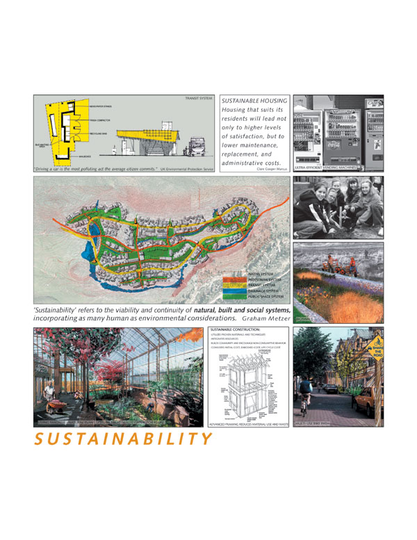
and permanence. An important ingredient for a healthy community is derived from the integration of sustainability into every
layer of planning and design. This master plan envisions a community that is socially desirable, economically viable,
and ecologically sustainable for generations to come. Proven research and technologies have been integrated into the planning
process from the outset with facilities and systems that are both high-tech and no-tech to promote non-consumptive values.
This approach will result in a model project that establishes a new threshold for excellence by achieving density while
minimizing impact on the land, incorporating sustainable design principles at every opportunity, and responding to how people
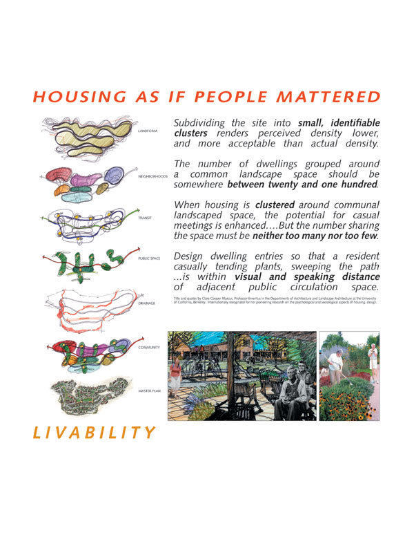
live, work, rest and move. DHM Design's team looked at six primary systems in developing the overall master plan for
Burlingame to create a layered plan that speaks to both livability and sustainability. Those six systems included: landform,
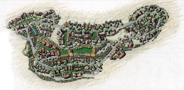
neighborhoods, transit, public space, drainage, and community.
Landform: The site is approximately 31 acres in size with the history of the site tied to the ranching operations of
the adjacent Bar/X Ranch. The site has an open rural character. Moving from east to west the site slopes over ninety feet
with three distinctive, flatter benches. Two knolls mark the entry to the site from the south and a series of landforms
and low points within the site give further definition to the character of the site. The landscape is dominated by native
grasses and sage communities with few trees.
Existing landforms and topography were a significant factor in shaping the site plan. Building orientation responded to
the natural topography of the site minimizing cut and fill. Road layouts, neighborhood patterns, drainage systems and
pedestrian trails all are sensitive to maintaining the existing topography and landforms. Additionally, the proposed master
plan is respectful of the existing landscape and draws the native vegetation into the site in many locations creating
an ambiguous line between development and open space.
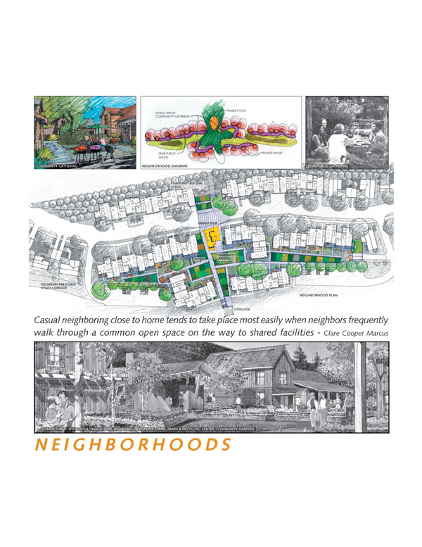
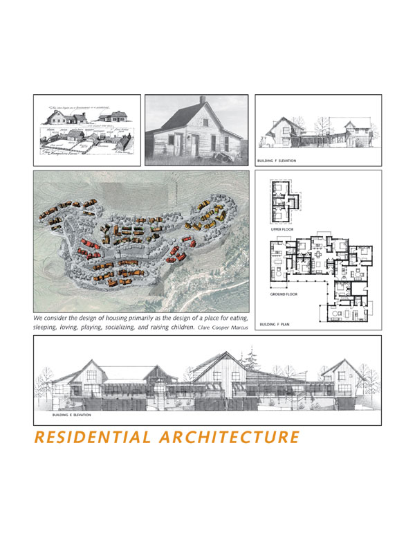
Neighborhoods: While the overall master plan for Burlingame needed to embody a sense of unity, the way in which individuals
interact and relate is at a much smaller and more intimate scale. Our approach has been to consider a series of neighborhoods
within a larger community. This plan proposes a community of 236 units divided into six neighborhoods, centered on a
common core. Densities within the neighborhoods range from 25-70 units.
A series of density studies helped in an analysis of the carrying capacity of the land. With
the underlying goal of creating a livable and sustainable community, the ultimate density settled at 236 units for sale. While the development
guidelines allowed for a maximum density of 330 units, our analysis found that this level of density had too great an
impact on the land, compromising open space and public space. At a density of 236 units, the master plan was able to preserve
50% of the site as open space. Based on a market analysis as well as City of Aspen preferences, the site plan proposes
fully integrated neighborhoods; an address does not define one’s economic status. From the building exteriors,
there is no distinction between different category levels of income.
Important to the success of the neighborhoods is the character of the architecture. Utilizing primary
forms reminiscent of historic western ranch vernacular, the buildings give homage to the ranching tradition of the site. On working ranches,
as buildings were required to grow, the rancher would combine simple-form shelters in what has later become described
as “additive architecture". This vernacular reflects the western ranch heritage and provides identity
to forms within the community and neighborhoods. Primary sheltering forms are combined, transposed and hyphenated within well-proportioned
compositions to create individual buildings. Integration of units within each building creates movement and individuality
within each structure, avoiding repetition of structures on the site. Massing is reduced at the entry to each unit, providing
human scale. Architectural detailing of front porches, window trim, and material transitions are consistent with expectations
of family residential construction.
Transit: To support the vitality of the neighborhoods, this master plan encourages residents to leave their cars at home
whenever possible and creates incentives for a lifestyle that is less consumptive. A local bus route has been designed to
cover the entire site with eight transit stops interspersed throughout the community. A resident will not have to walk
more than 350 feet from their home to a local bus stop.
The community-wide transit loop is integrated into the public space system. The transit loop consists of a two-way road
system with road grades of less than 5% to meet accessibility requirements. Each transit stop includes a whole host of
neighborhood amenities – a bus stop, mailboxes, newspaper stands, recycling and trash receptacles. The location of the transit
stops within each of the neighborhoods makes transit a central part of daily life. The transit stations become a focus of
social activity – a place to meet and greet one’s neighbors while attending to the routines of day-to-day living.
Bicycle and pedestrian traffic are encouraged throughout the project. A regional bike trail passes through the center
of the proposed conceptual master plan, creating a central spine in the heart of the project and an emphasis on non-motorized
movement. While limited one-way vehicle traffic is accommodated on this route, the materials selected create a pedestrian
scaled environment and encourage residents and visitors to travel by bike and foot. This spine serves as a regional trail
system and is supported by a variety of trails and sidewalks that weave through the project site.
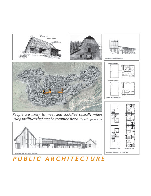
Public Space: The public space network is designed to create the opportunity for a rich social fabric. The site plan accommodates
a hierarchy of public spaces from the large common gathering areas at the Commons facility and the great lawn, to the neighborhood
centers defined by shared social activities, to the more intimate patio and porch layouts at individual building entries. These
layers of public space are defined without creating a rigid appearance and there is a logical progression from one level
of interaction to the next.
The large common gathering area is located at the center of the development and includes a place where neighbors can
interact, children are cared for during the work day, artisans can work and community workshops facilities are shared. This
space is more civic in quality. The Commons is a centralized building planned to house a gathering room, day care facility,
vending kiosk and workshop facility where residents can share work space and tools. (The City of Aspen specifically excluded
programmatic considerations for other commercial, institutional, or governmental uses.) The vending kiosk is a concept derived
from Japanese society, where many every day consumer items are available at vending centers. Energy efficient vending
machines dispensing everything from milk and eggs to ball point pens and power bars will reduce trip generation from
those inconvenient one-item jaunts to the grocery store.
Surrounding the Commons are Live-Work residential units. Aspen has many entrepreneurs who work, or would like to work
from home. Designed as a residential unit on one floor and a work space on the other, these units can be converted to additional
living space, or work space as each owner requires. The location of the work spaces facing onto the public commons will allow
for “spill out” into the green thereby enhancing the life and fabric of the community.
At the neighborhood level, each neighborhood is organized around a centralized public space. Neighborhood density is
concentrated toward the center with less density moving toward the edges; single family lots tend to be located on the periphery
of the individual neighborhoods. This level of public space is designed with a built-in flexibility and can evolve over
time to express the unique values of a given neighborhood. Garden plots provide opportunities where residents can cultivate
food, flowers, and especially social contact. An orchard, or a specially designed playground might define other neighborhood
spaces.
At the unit level, there becomes an active dialog between the front door, the porch, the semi-private space, and the
public space. This relationship creates a rich vibrant interaction that adds energy to each neighborhood and to the community
as a whole.
Drainage: Natural drainage patterns and systems are incorporated into the site plan in an integrated and holistic manner helping
to define and strengthen other components of the proposal. Storm water management is developed into a site amenity which
helps to define public space rather than being routed through an underground system. Plantings adjacent to the drainageways
take advantage of intermittent moisture and add to the overall character of the community. Vegetated swales (bio-swales)
collect storm water runoff, clean the water and protect receiving waters from the effects of sediment and pollution. These landscaped
swales provide an aesthetic as well as a functional component to the master plan, enlivening public spaces with a rich and
varied landscape palette.
Community: The integration of these patterns and systems creates a richly layered community that responds to the social
and physical needs of the residents. The conceptual plan expresses a lifestyle that emphasizes shared open space, community gardens
and orchards, a natural landscape enhanced by seasonal drainage, clustered neighborhoods with a strong bike and pedestrian
linkage, common facilities located in the center of the site, a looped transit route and energy efficient units and buildings
which reflect a ranch vernacular style. Housing units have been located to increase the possibility of neighbors meeting
and of a sense of community developing. The line between public, semi-public and private spaces is ambiguous creating a sense
of collective ownership. The summation of the parts results in an overall community that emphasizes neighborhood commitment
at a physical, social and human scale.
At the request of the City, this project will be constructed in three phases. Phasing limits were determined after an analysis
of the financial resources of the City and logical construction sequencing. The organized hierarchy of spaces were established
in phase one so subsequent phases could be easily added. Final land use approvals for phase one of the project were granted
in April of this year with construction scheduled to begin in late June. During and after construction, sustainable design
and construction techniques will be monitored and documented to determine ultimate efficiencies, such as a comparison of
actual energy usage to modeling completed during the planning process. Construction sub-contractors will be required to
complete an on-site educational session outlining all aspects of the sustainable design package so that details are correctly
implemented in the field. Final planning and design of phases two and three will be completed after a post-occupancy analysis
of phase one has been completed.
Developing Burlingame Ranch has been a fluid process intermixing research, analysis, planning
and design. This integrated approach, combined with an understanding of history and previous planning
efforts can direct planning and design in the most positive way. The results will be a project that is appropriate
in character, fitting for its setting, intentionally balanced and holistic without focusing on a single direction – sustainability
at the expense of community or sacrificing design or planning for the sake of the other.
|