


Honor Award
Reclaiming the Shoreline: Redefining Indiana's Lake Michigan Coast
Dane Carlson, Student ASLA, Undergraduate, Ball State University
Faculty Advisor: Meg Calkins, ASLA
 Close Me!
Planning Consideration: The site is inextricably tied to several issues regarding community and ecology, and these considerations are paramount to design development on site. The site becomes an amalgamation of solutions to existing problems.
Download Hi-Res ImageImage: Dane Carlson
Image 2 of 15
 Close Me!
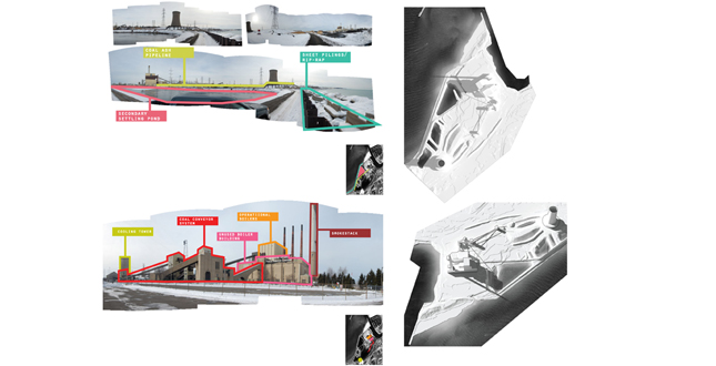
Analysis and Existing Features: The design evolves around a framework of existing industrial infrastructure. All elements of the coal generating station are utilized with the purpose of material efficiency as well as recognition of the evolutionary stages of the place.
Download Hi-Res ImageImage: Dane Carlson
Image 3 of 15
 Close Me!
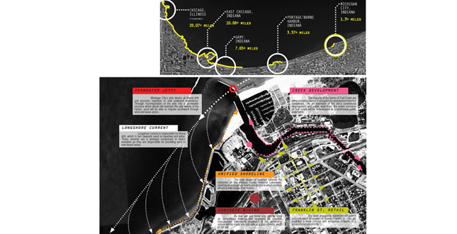
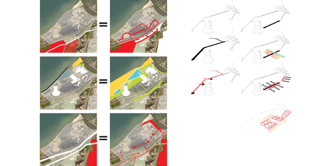
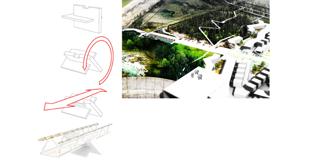
Conceptual Development: Each major design intervention is informed by existing community and ecological issues: connection to existing neighborhoods, extension of an existing commercial corridor, and creation of a functional shoreline.
Download Hi-Res ImageImage: Dane Carlson
Image 4 of 15
 Close Me!
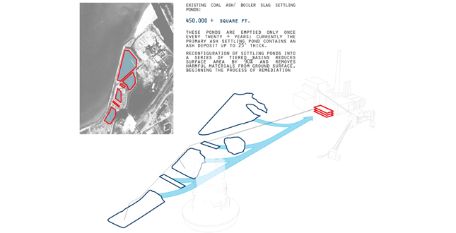
Initial Remediation: Reconfiguration and relocation of ash and boiler slag settling ponds removes the settling process from the ground plane.
Download Hi-Res ImageImage: Dane Carlson
Image 5 of 15
 Close Me!
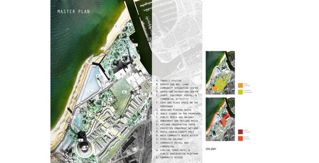
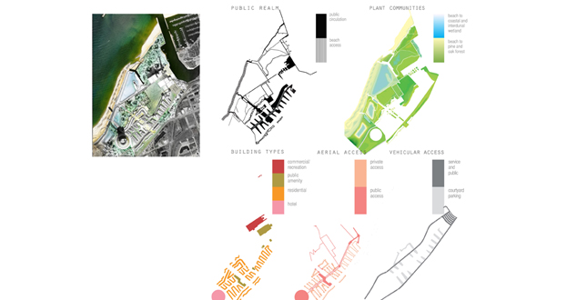
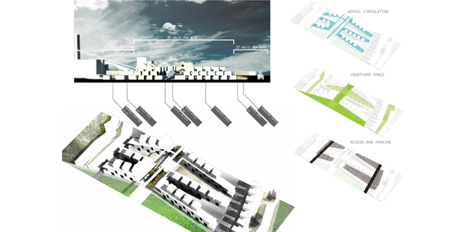
Master Plan Elements: Systems of circulation, ecology, and community are closely woven to provide ease of access to amenities for both residents and visitors; pedestrian activity becomes paramount.
Download Hi-Res ImageImage: Dane Carlson
Image 6 of 15
 Close Me!
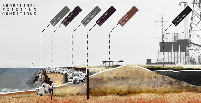
Shoreline Intervention: The primary ecological component is the rebuilding of a functional shoreline which existed prior to embankment. Existing conditions, consisting of a series of retaining walls, prevent natural formations and pedestrian access.
Download Hi-Res ImageImage: Dane Carlson
Image 7 of 15
 Close Me!
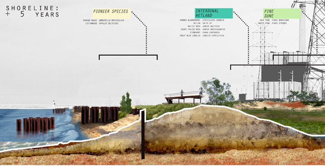
Shoreline Intervention: Removal of the initial layer of sheet pilling allows for the reconfiguration of this material to accelerate sand accretion. As sand levels rise, pioneer species begin dune formation. Settling ponds are transformed into interdunal wetlands, remediating toxic soil.
Download Hi-Res ImageImage: Dane Carlson
Image 8 of 15
 Close Me!
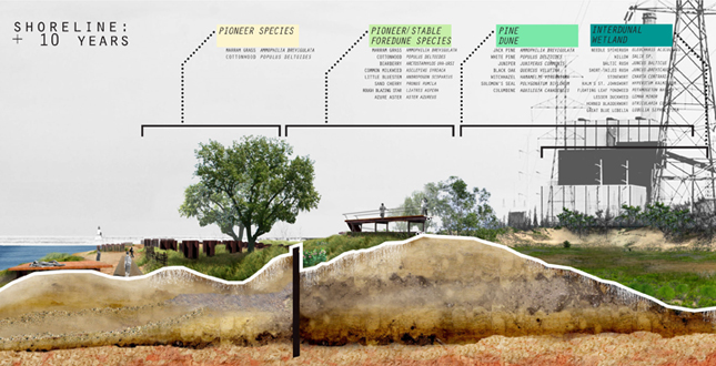
Shoreline Intervention: After ten years, a new layer of foredunes have developed and protect the vulnerable dunes and vegetation behind them. The beach is publically accessible with certain measures being taken to maintain vegetative mass.
Download Hi-Res ImageImage: Dane Carlson
Image 9 of 15
 Close Me!
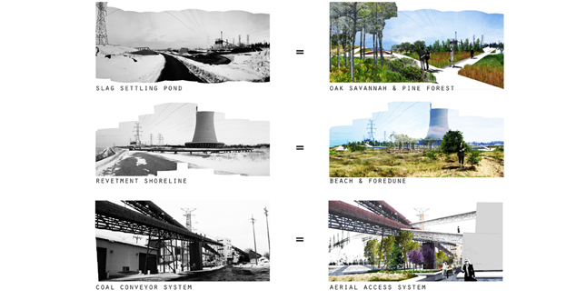
Remediation and Reclamation: Existing topography and infrastructure create diverse new systems for ecology and community. Depressions become wetlands, the shoreline becomes a beach, and coal infrastructure becomes residential amenity.
Download Hi-Res ImageImage: Dane Carlson
Image 10 of 15
 Close Me!
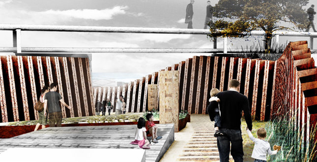
Beach Access Pathways: Reclaimed steel sheet pilling creates artificial gulley below the pipeline walkway, establishing routes for easy beach access. Sand and wood form the primary material palette and contrast the steel walls.
Download Hi-Res ImageImage: Dane Carlson
Image 11 of 15
 Close Me!
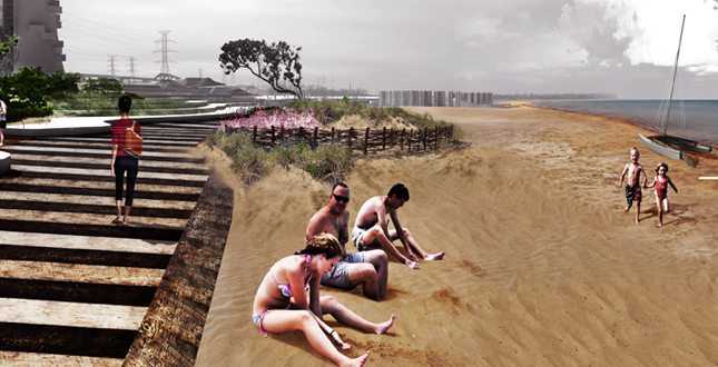
Public Beach: An existing beach is transformed into the primary public attraction. A wooden walkway provides access and is flanked by simulated embryo dunes which prevent excessive migration of accumulated sand.
Download Hi-Res ImageImage: Dane Carlson
Image 12 of 15
 Close Me!
Material Reuse: Man made rip-rap, known as accropode, is used as the structural base for walkways stretching throughout the pie and oak forests on site.
Download Hi-Res ImageImage: Dane Carlson
Image 13 of 15
 Close Me!
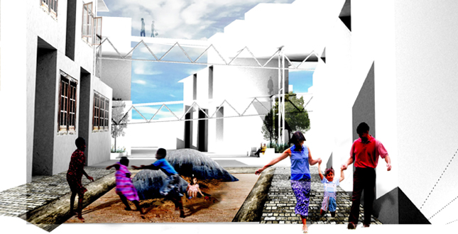
Residences/Community: Community development provides a variety of densities as well as constant frontage on open space. Interior courtyards provide space for play or contemplation while the central avenue is the principal pedestrian route.
Download Hi-Res ImageImage: Dane Carlson
Image 14 of 15
 Close Me!
Community Courtyards: Between residences lie semi-private courtyards, allowing each unit to front on vibrant open space usable throughout the seasons as a playspace.
Download Hi-Res ImageImage: Dane Carlson
Image 15 of 15
Project Statement
The coal generating station in Michigan City, Indiana is one of a series of industrial complexes which have dominated the shoreline of Lake Michigan for decades, bringing with them pollution of ground and water and crippled shorelines. This design solution utilizes the framework of industrial infrastructure to return the site to ecological and community function; as ecological processes develop through a series of phases, human inhabitation brings the site to life.
Project Narrative
—2011 Student Awards Jury
Context & Site
Initially developed as a power generating station by the Northern Indiana Public Service Company in the early 1930s, this site has suffered enormously through several phases of development. Byproducts of coal combustion are distributed throughout, potentially mixing heavy metals and other toxins with rain water, which then seeps into the ground. Any ecological community which existed previously is forgotten. The plant continues to function through today, and as a result this plan proposes a series of phases in site reclamation through the plant's decommissioning and beyond.
To the northeast, the lighthouse jetty of Michigan City's harbor prevents any shoreline to its immediate south from receiving new sediment input. As a result, this shoreline has been subject to massive erosion of existing dunes and destruction of ecological communities. This necessitates the site's shoreline stabilization, which is accomplished by two layers of steel sheet pilings and large piles of concrete rip-rap. These factors prevent the formation of dunes and healthy ecological communities along the shoreline. Coal ash settling ponds are located adjacent to the lakeshore and are not lined, and a massive pile of coal (up to 150,000 tons) is stored on-site. Both of these features are potentially responsible for groundwater and soil pollution.
Neighborhoods surrounding the site fall well below typical standards of education and income. In addition to its aesthetic nuisance, the site is completely enclosed by fences and is inaccessible to any members of the community. Across Trail Creek lies Michigan City's enormously popular public beach, while the location of the plant prevents a massive portion of the shoreline from being used for recreation or other functions.
Program
The program consists of three primary components: ecological development, creation of a public realm and spatial network, and community development. Rather than creating the site as a destination, the program intends to extend all surrounding elements directly into the site design.
Ecology
Reestablishment of tiered dune ecosystems is the primary component of ecological restoration. The introduction of new sediment flows through littoral drift and longshore current, in addition to the creation of a semi-permeable jetty, allows for the accretion of sand along the shoreline, and this process is accelerated by the staggered formations of sheet pilings driven into the lakebed. As a new layer of dunes form here, landward sand becomes stabilized by pioneer vegetation, allowing it to host new and varied plant communities.
Four intradunal wetlands, also known as pannes, and one coastal wetland replace the series of ash settling ponds along the shoreline. The remaining layer of sheet piling, together with a sub-grade sheet of clay, forms a waterproof barrier leading to the accumulation of water at the bottom of each depression. The wet feet of each depression make them uniquely suitable to host rushes and sedges which form the basis of panne plant communities.
The creation of dune forests inland of the shoreline mimics the natural progression of successional dune ecologies. The initial layer of dunes begins organic matter accumulation with cottonwood and dunegrass. Jack pine forest and oak savannah inhabit the layers of dune beyond this, and oak/hickory forests beyond these. Introduction of these tiers of dune evolution creates the basis for a permanently evolving, functional ecological system which mimics that of the national lakeshore to the south.
Community
Introduction of dense residential development allows the site to be a place of inhabitation as well as a destination. Located directly north of an existing neighborhood, this new community provides pedestrian connections to existing streets and allows residents from surrounding communities to access pedestrian circulation routes into the heart of the site. Community development lies on the site's southern portion, maintaining the northern reaches as a place for ecological growth, ecotourism, and education. All homes front on open space and residents can easily access woodland canopies or recreational hotspots through aerial circulation systems. A central node makes basic services, such as daycare and grocery, within walking distance of homes.
Public Realm
The most iconic features of the generating station, in addition to most of the auxiliary structures, are adapted into public amenities. In the west, the cooling tower becomes a hotel, providing a viewing platform for the public and creating an anchor for the aerial circulation system. This system extends eastward through the community, carving a path for the creation of a green avenue defined by woodland plantings. To the east, both boiler houses host sport courts and adventure recreation due to their proximity to the creek's waterfront. Here, an extension of the Franklin Street corridor forms the primary commercial and open public space on site. Access extends northward, connecting this attraction to the public beach through a series of woodland and waterside pathways open only to pedestrians.
Plant List
Pioneer Species: Marram Grass, Cottonwood. Stable Foredune Species: Cottonwood, Marram Grass, Bearberry, Common Milkweed, Little Bluestem, Sand Cherry, Rough Blazing Star, Azure Aster. Pine/Oak Dune Species: Jackpine, White Pine, Juniper, Black Oak, Witchhazel, Solomon's Seal, Columbine. Wetland Species: Needle Spikerush, Willow, Baltic Rush, Short-tailed Rush, Stonewort, Kalm's St. Johnswort, Floating Lead Pondweed, Lesser Duckweed, Horned Bladderwort, Great Blue Lobelia
Additional Project Credits
Faculty Mentors
Chris Marlow and John Motloch
Dune and Ecology Specialists
Todd Thompson and Noel Pavlovic