


Honor Award
Salvage Park
Gillian Baresich, Student ASLA, Arizona State University
Faculty Advisors: Catherine Spellman and Zubin Shroff
 Close Me!
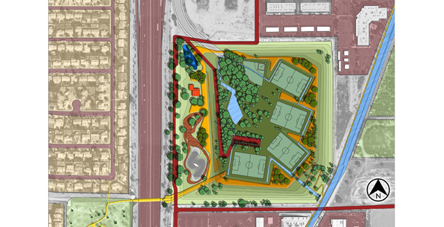
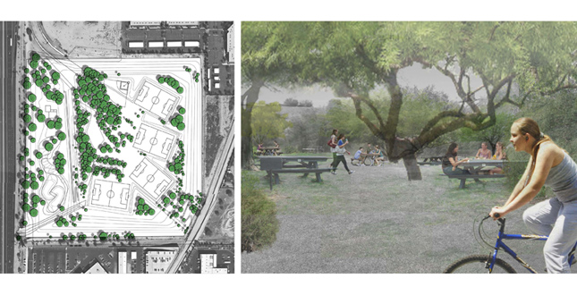
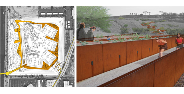
Site Plan. Located on the border o three major cities, Salvage Park has the opportunity to connect all three districts and allow for more pedestrian access between each city.
Download Hi-Res ImagePhoto: Gillian Baresich
Photo 2 of 15
 Close Me!
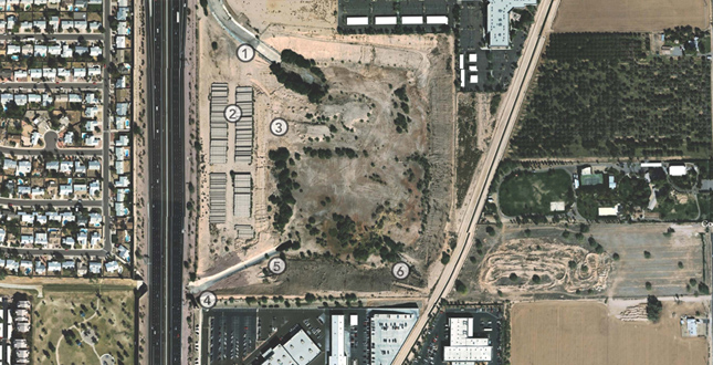
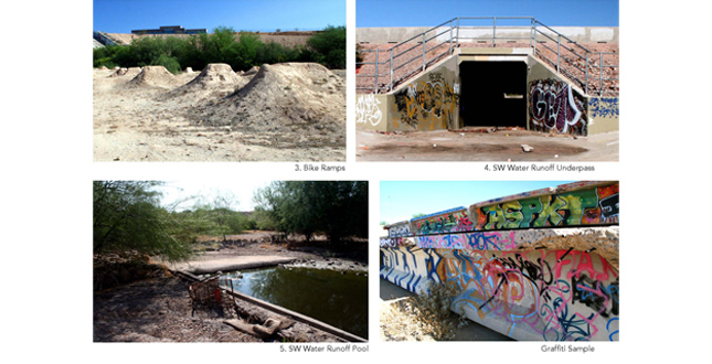
Existing Aerial Image. 1. NW Water Runoff Canal 2. Highway Panels 3. Bike Ramps; 4. SW Water Runoff Underpass; 5. SW Water Runoff Pool 6. SE Water Runoff.
Download Hi-Res ImagePhoto: Gillian Baresich
Photo 3 of 15
 Close Me!
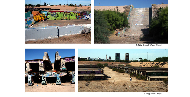
Top: NW Runoff Water Canal. Bottom: Highway Panels
Download Hi-Res ImagePhoto: Gillian Baresich
Photo 4 of 15
 Close Me!
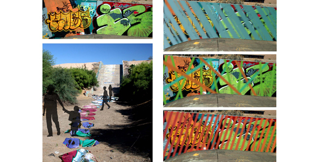
Top (left to right): Bike Ramps; SW Water Runoff Underpass. Bottom (left to right): SW Water Runoff Pool; Graffiti Sample.
Download Hi-Res ImagePhoto: Gillian Baresich
Photo 5 of 15
 Close Me!
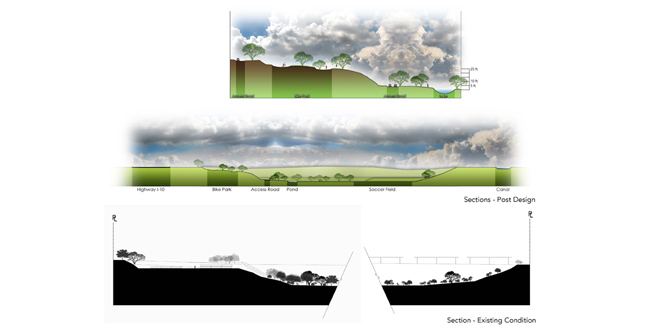
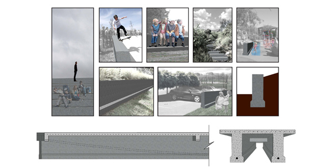
Top: Section – Post Design. Bottom: Section – Existing Condition.
Download Hi-Res ImagePhoto: Gillian Baresich
Photo 6 of 15
 Close Me!
Bosque of Trees. All existing trees will either be kept or relocated, with the intention of sustaining the current hospital climate. Planted areas will allow for shaded park space, something many public Arizona parks lack.
Download Hi-Res ImagePhoto: Gillian Baresich
Photo 7 of 15
 Close Me!
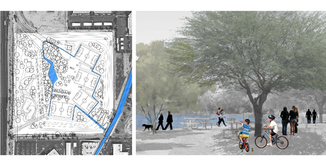
Water. Water from adjacent canal will be brought in to minimally irrigate the park and fill a small lake. Runoff from the canals will feed this system. All vegetation currently survives without additional irrigation.
Download Hi-Res ImagePhoto: Gillian Baresich
Photo 8 of 15
 Close Me!
Upper Terrace Level. One main terrace level will allow for pedestrian and bicycle transportation to all corners of the park. This terrace will also border the sports fields and allow for an elevated view.
Download Hi-Res ImagePhoto: Gillian Baresich
Photo 9 of 15
 Close Me!
Roads. There are three possible entry roads to allow vehicular transportation into the park. Adequate parking will be provided at the top of the basin as well as the bottom. Emergency access will also be provided.
Download Hi-Res ImagePhoto: Gillian Baresich
Photo 10 of 15
 Close Me!
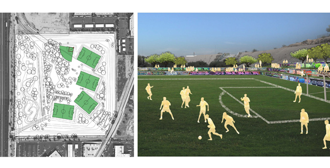
Sports Fields. Four soccer fields and one baseball field will be placed so each is uniquely situated from one another. Each field will be nestled within terraced seating made with the salvaged highway panels as retention walls.
Download Hi-Res ImagePhoto: Gillian Baresich
Photo 11 of 15
 Close Me!
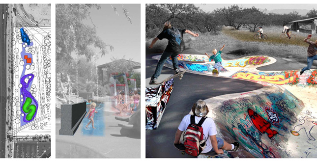
Upper Terrace Programs. This area contains both a small water park and a skate/bike park allowing for a variety of different users. Both of these programs allow the creative use of graffiti and connect to the previous site uses.
Download Hi-Res ImagePhoto: Gillian Baresich
Photo 12 of 15
 Close Me!
Highway Panels. The site already contains around 200, 70-foot-long highway panels used for making highway surfaces. Most of these pieces are already covered in graffiti and could easily be used throughout the park as infrastructure.
Download Hi-Res ImagePhoto: Gillian Baresich
Photo 13 of 15
 Close Me!
Methods of Censoring Crude Graffiti. Without destroying the artistic culture already existing on this site, several methods have been considered in salvaging the graffiti currently found on the site.
Download Hi-Res ImagePhoto: Gillian Baresich
Photo 14 of 15
 Close Me!
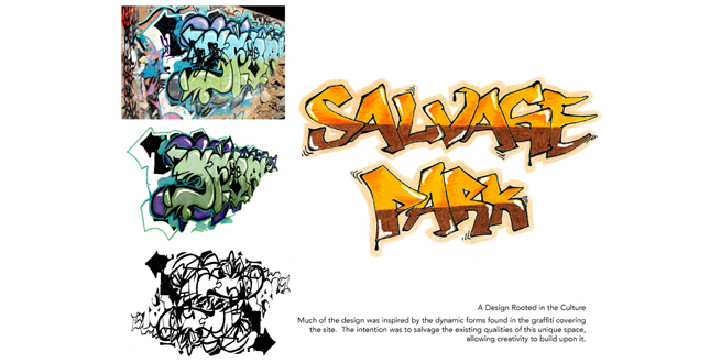
A Design Rooted in the Culture. Much of the design was inspired by the dynamic forms found in the graffiti covering the site. The intention was to salvage the existing qualities of this unique space, allowing creativity to build upon it.
Download Hi-Res ImagePhoto: Gillian Baresich
Photo 15 of 15
Project Statement
Today, public parks are designed as though they are given a blank canvas to work from. However, many park sites already contain existing users, mostly undesirable. Salvage Park conversely, embraces these cultures and encourages users to build upon the established space instead of destroying it. Through salvaging elements such as graffiti, abandoned highway panels, existing vegetation, and infrastructure, Salvage Park sustains and connects to the people around it, while acting as a successful sports facility.
Project Narrative
How does one take a piece of infrastructure currently used as an eighty foot deep retention basin for highway and residential runoff and turn it around into a successful public park containing several sports fields while attempting to keep the cost to a minimum? This is was the question posed by the Parks and Recreation Department, a division of the City of Tempe, who was looking for ideas in how design could be utilized to create a unique space. Through careful consideration of each of the city’s needs, as well as working towards salvaging all of the existing cultures and elements provided by the site, Salvage Park creates a unique solution to the currently underutilized space.
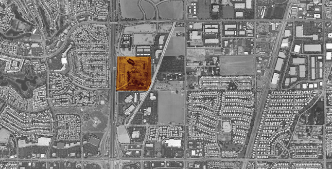
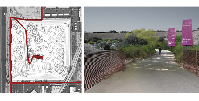
Located on the border of three cities, the site in consideration is located alongside a major highway, surrounded by several residential communities, as well as a large commercial district. The community being a highly diverse area was in need of something that could pull each of the separated cities together. The highway currently divides the cities in two, and doesn’t provide any pedestrian access through the site for the surrounding neighborhoods. Several school systems nearby depend on sports facilities and parks located elsewhere and the City of Tempe was looking for a solution to the lack of soccer and baseball fields within the area. The site is perfectly located in an area which would provide not only Tempe, but Phoenix and Chandler access to these facilities. The park would also act as a neighborhood node for the surrounding residential communities to gather and interact, as well as allow pedestrians access through the highway via underpass.
The first step of this project was to visit the site and document and experience what already exists. When first entering the site, one could understand a strong culture already existing within the area. Every square inch of concrete surface was covered in graffiti, and old spray paint cans littered the ground. However, it was surprising to find the majority of the defaced property wasn’t covered in obscenities, but rather creative pieces of art. Since the space wasn’t commonly used by the public, the space had become its own private graffiti art gallery. From that first visit it became clear to consider this graffiti culture as an opportunity rather than a problem.
Located on the west edge of the site was a terrace which held around 200, seventy-foot-long, used, concrete highway panels. They were currently being in storage until a new use could be found for them. Each piece was being used as a mural space for the graffiti artists, and created a unique, gallery experience with layers upon layers of multicolored spray paint. The site also contained other surprises, such as highly vegetated areas providing a pleasant climate as well as some wildlife like rabbits and desert squirrels. Handmade bike ramps were also found along the bottom of the basin, and looked to be heavily used.
After visiting the site, the first objective was established: to retain the existing culture that already infiltrated the area and turn it from an illegal form of vandalism into a public form of art. The first step in the design process included working with the forms and colors of the art of graffiti in order to organize the programs of the site. By keeping the existing graffiti and censoring it by layering patterns and inviting graffiti artists to create new mural pieces that are publicly appropriate, the park can provide an outlet for those who want spaces to display their work.
Along with the soccer and baseball field programs, there was a strong connection to biking, skating, and water which already existing on the site. By providing the site with a skate and bike park and basing the design on the unique forms created by graffiti, the city can provide the community with an element it obviously needs. The concrete elements of the skate park would also allow for a perfect canvas for graffiti artists to create a public art mural which could change over time.
The park would also provide a small water park which would be fed by the water from the adjacent canal. Each of the runoff canals would fill up during heavy rains and create smaller lakes which would feed irrigation water throughout the site to the sports fields and vegetated areas. This connection with water and allowing the processes to be visible to the public would educate the community to utilize water as efficiently as possible.
Another main objective of the park was the reuse of the concrete highway panels as park infrastructural elements. After coming up with many possible uses, the park could set a precedent in utilizing these used highway infrastructure pieces as urban park elements. Some uses included retaining walls, pedestrian bridges, skate park railings, and fences. The retaining walls were used for seating along the soccer and baseball fields, and allowed for the idea to separate each field by terraced seating.
One major issue which needed to be addressed was how to provide access into the eighty-foot-deep basin. The solution became clear that a series of ramps and stairs could create an interesting procession as one moved into the space. By running a street down to the bottom of the site and providing parking along the top and bottom, access is easily provided for handicapped and emergency vehicles. There are also a series of pedestrian entrances from each side of the site which utilize unique, angular pathways across the entire park. Along the Western edge of the park is a major highway, and existing is an access tunnel connecting a neighboring park to the retention basin for runoff purposes. The tunnel would be retrofitted as a major connecting pathway that would allow pedestrians access under the highway instead of alongside it.
Much of the proposed vegetation is already provided by the existing landscape within the site. Many of these mature palo verdes and mesquite trees only would be transplanted to provide a more manicured landscape. Since many of these trees are already growing naturally, irrigation can be kept to a minimum. The earthworks proposed for the site utilize cut and fill methods, without any need to truck earth in or out of the site. The major cuts proposed were designed to create a space inspired by the forms of graffiti already covering the site. The main terrace level provides a loop around the park, connecting each program, allowing transportation from the bottom to the top and presents these unique cut and fill forms. Nestled within this terrace are the sports fields, allowing for terraced seating to surround each of the fields.
Each of these elements combine to create a unique public space which attempts to connect with the existing culture of the site. The process of construction for this park would consider LEED methods and could easily work to abide by a sustainable standard. After long consideration, it became obvious that the name of the park should exemplify the intentions behind the design, and thus, Salvage Park was created. The act of salvaging the existing program, concrete highway panels, vegetation, etc., would become the basis of a new park typology and allow for responsible and distinctive community park designs in the future.
During the design process, the City of Tempe collaborated with the designers on several occasions in order to allow for strong communication between both parties. The design was presented during the City Council’s Neighborhood Parks Rehabilitation & Maintenance Committee Meeting and received strong interest. In order for the design to be considered for construction, the City would need to locate the appropriate funds before moving ahead. A rough cost estimate was presented and considered for the completed design.
The process of design for Salvage Park was one that listened strongly to the needs of the site, and balanced the clients wishes with the surrounding community. If the park eventually becomes realized, the design will turn an existing piece of infrastructure into a community anchor, pulling people from three separated cities together.
Additional Project Credits
Additional Team Member
Natalia Mattingly, Student Affiliate ASLA
Tempe City Council's Neighborhood Parks and Rehabilitation and Maintenance Committee
Google Earth for satellite imagery