


Honor Award
Puddlescape: Freshwater Marsh and the
Urban Matrix
Delia Kulukundis, Student ASLA, University of Virginia
Faculty Advisors: Jorg Sieweke and Kristina Hill
 Close Me!
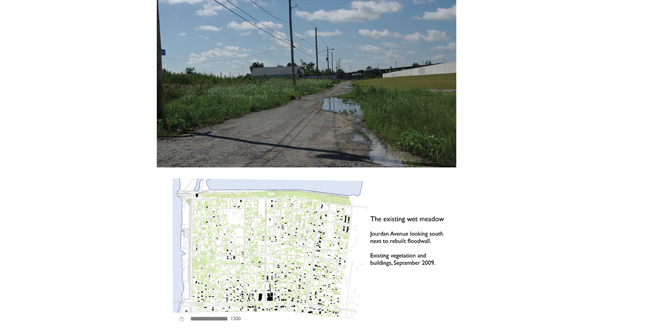
The existing wet meadow. Top: Jourdan Avenue looking south next to rebuilt floodwall. Bottom: Existing vegetation and buildings, September 2009.
Download Hi-Res ImagePhoto: Jorg Sieweke and Delia Kulukundis
Photo 2 of 14
 Close Me!
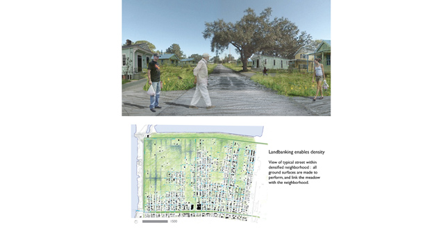
Landbanking enables density. View of typical street within densified neighborhood: all ground surfaces are made to perform, and link the meadow with the neighborhood.
Download Hi-Res ImagePhoto: Delia Kulukundis
Photo 3 of 14
 Close Me!
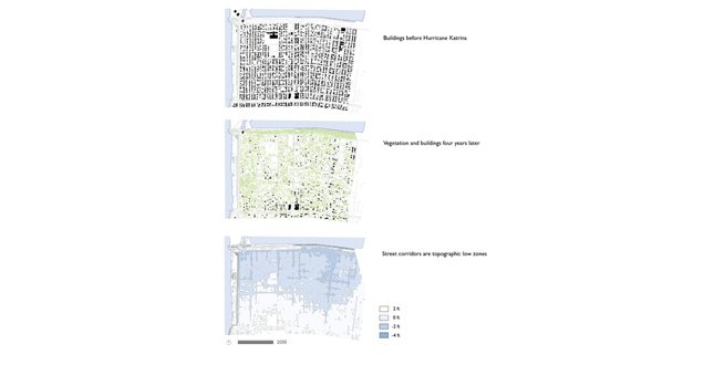
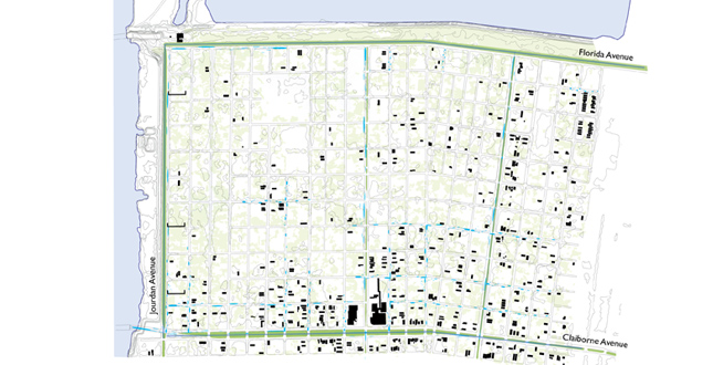
Existing Conditions: Top: Buildings before Hurricane Katrina. Middle: Vegetation and buildings four years later. Bottom: Street corridors are topographic low zones.
Download Hi-Res ImagePhoto: Delia Kulukundis
Photo 4 of 14
 Close Me!
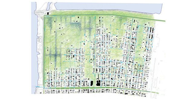
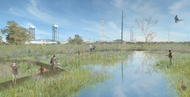
Proposed Rebuilding Strategy. Top: Rebuild—Encourage density within priority zones along former commercial corridors and major streets. Middle: Preserve—Areas planted with freshwater marsh grasses provide are source for recreation and fishing, as well as habitat for migratory birds. Ponds in low zones store stormwater, reducing the level of pumping necessary to prevent neighborhood flooding in normal storms. Bottom: Mesh—Community program zones provide points of entry into the marsh landscape. Schools are able to use the marsh as a park and a learning environment.
Download Hi-Res ImagePhoto: Delia Kulukundis
Photo 5 of 14
 Close Me!
Phase 1. Establish water storage greenways along Jourdan, Claiborne, and Florida Avenues, with pedestrian and bicycle connections to greater New Orleans.
Download Hi-Res ImagePhoto: Delia Kulukundis
Photo 6 of 14
 Close Me!
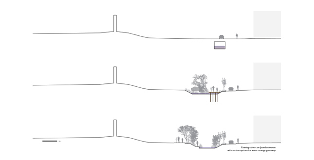
Existing culvert on Jourdan Avenue with section options for water storage greenway.
Download Hi-Res ImagePhoto: Delia Kulukundis
Photo 7 of 14
 Close Me!
Phase II. Neighborhood rebuilding along Claiborne, Caffin, and Tupelo Avenues. Water retention texture on rebuilt roads, with streetside swales that direct water into meadow reservoirs.
Download Hi-Res ImagePhoto: Delia Kulukundis
Photo 8 of 14
 Close Me!
All surfaces are expected to perform water management functions: evaporation, infiltration, storage, conveyance.
Download Hi-Res ImagePhoto: Delia Kulukundis
Photo 9 of 14
 Close Me!
Phase III. Developing neighborhood density.
Download Hi-Res ImagePhoto: Delia Kulukundis
Photo 10 of 14
 Close Me!
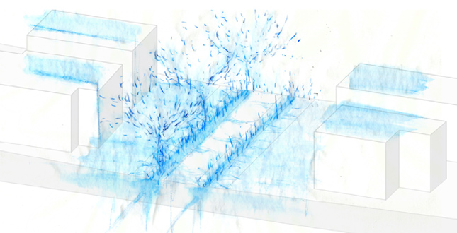
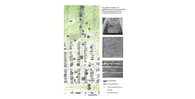
The meadow is linked to the neighborhood with the water-retaining textures that signal distance from crosswalks and pedestrian zones.
Download Hi-Res ImagePhoto: Delia Kulukundis
Photo 11 of 14
 Close Me!
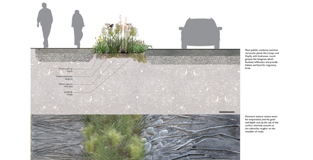
Top: Plant palette combines common vernacular plants like Liriope and Daylily with freshwater marsh grasses like Sawgrass, which facilitate infiltration and provide habitat and food for migratory birds. Bottom: Pavement texture retains water for evaporation, and the grain and depth vary by the use of the surface, relatively smooth on the sidewalks, rougher on the shoulder of roads.
Download Hi-Res ImagePhoto: Delia Kulukundis
Photo 12 of 14
Project Statement
Expanses of flat, vacant land make the Lower Ninth Ward look like a wet meadow. This project proposes a transformation of the landscape matrix that allows the Lower Ninth Ward to regain its vibrant neighborhood density while appreciating the water and plants as valuable resources. From sidewalks to ponds, the ground is demonstrated to perform as a sponge and a reservoir across multiple scales and materials, revealing the presence, movement, poetry, and productivity of water.
Project Narrative
A visit to the Lower Ninth Ward reveals a wet meadow occasionally punctuated by houses along a crumbling but still-present street grid, while the foundations of former houses and utility poles along the streets hint at the neighborhood's density before Hurricane Katrina. This project reimagines the wet meadow condition as the landscape matrix, performing as water management infrastructure and providing a recreational resource for the regenerating neighborhood.
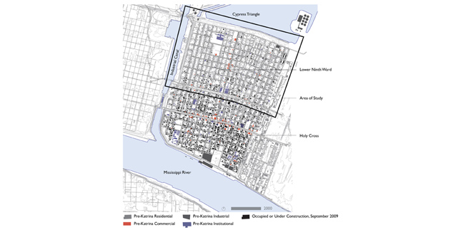
By June 2009, the Lower Ninth Ward had regained only 19% of its pre-Katrina population. Landbanking allows the Lower Ninth Ward to regain its former density and neighborhood fabric by concentrating future rebuilding efforts along Claiborne, Tupelo, and Caffin Avenues, which are currently the areas of highest population density. Areas of vacant land are reserved as a wet meadow, seeded with plants from Louisiana's freshwater marsh landscapes. Parcels on the edge between the meadow and the neighborhood are used for programs that serve the community, such as schools, community centers, and grocery stores. These places serve as entry points into the meadow landscape, and can use space in the meadow for outdoor recreational and educational programs, as well as for food production and fishing.
Louisiana's freshwater marshes have some of the most diverse bird life in the delta, but are experiencing some of the greatest reduction in acreage due to saltwater intrusion; plant communities from the freshwater marshes provide habitat for migratory waterbirds, and make the neighborhood an important birdwatching destination within the city. The meadow becomes a productive and recreational landscape for residents of the neighborhood, as well as the greater New Orleans community, which is connected by bike paths along the perimeter of the neighborhood.
New Orleans is overwhelmingly a flat landscape, but in the Lower Ninth Ward the street corridors are topographical low zones, and can be up to two feet lower than the surrounding blocks, which makes them natural areas for water storage. Major avenues are retrofitted with greenways that provide pedestrian and bicycle paths while storing and conveying stormwater. Large-scale water storage is performed in ponds along the former street corridors in the meadow areas. The New Orleans Sewerage and Water Board currently pumps water out of the city's neighborhoods every day in order to maintain dry conditions; by storing water in the landscape, there is a reduced need to pump water out of the Lower Ninth Ward under normal conditions and in the case of a 10-year storm.
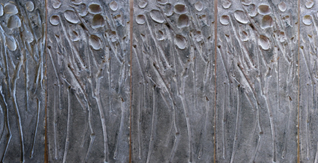
The meadow becomes part of the city fabric through textural changes in the areas that are rebuilt. Stormwater retention swales combine plants from the freshwater marsh with common vernacular plants. As streets are repaved, the concrete is given a textural imprint that retains a surface layer of water for later evaporation and brings the marsh texture into the paved space. The depth and density of the imprint are varied to allow the texture to serve traffic-directing and calming functions. Each level of ground surface retains stormwater for infiltration and evaporation, then conveys the excess to an area of higher capacity. The sidewalk and road surfaces retain a thin layer of water for evaporation and direct the excess into swales, which facilitate infiltration and convey the excess into the larger ponds in the meadows. At each scale the presence and movement of water is revealed, while the urban condition is remembered in the meadow with water tracing the former streets and utility poles continuing to serve as location markers and lights.
Additional Project Credits
The Dew Traveling Studio at the University of Virginia for the opportunity to visit New Orleans in October 2009
Guidance and feedback from Robin Dripps and Bill Sherman at the University of Virginia