

«previous pageANALYSIS & PLANNING CATEGORY
Honors Award
Rockefeller Park Strategic Master Plan, Cleveland, OH
Siteworks,
Charlottesville, VA
client: Parkworks, University Circle Incorporated, The Cleveland Foundation
Project Statement
This planning effort for Rockefeller Park introduces a layered system of design strategies that simultaneously address issues of regenerating ecological functionality, sustaining cultural health and re-establishing community vibrancy. Building upon a long history of unrealized analytical masterplans, the design strategies explored in this project were developed in a fashion aimed at incremental implementation over time, acknowledging the financial and political constraints faced by the city of Cleveland and looking for opportunities to form collaborative partnerships with a series of ongoing private, cultural and civic infrastructure efforts.
This project, in particular, seeks to merge these efforts and create interwoven relationships between ecological and cultural health. Approaches, both modular and systems-oriented, intend to create a meaningful and memorable experiential condition within the park and surrounding neighborhoods that re- knits the cultural and ecological fabric of the Doan Brook Watershed and the city of Cleveland.
Project Narrative
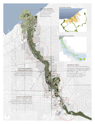
Rockefeller Park encompasses roughly 200 acres on the east side of Cleveland, Ohio extending from the banks of Lake Erie in the north, to Rudy Rogers Park in the south. The park is defined geographically by the linear drainage of the Doan Brook Watershed that connects the Shaker Lakes to Lake Erie and culturally by the diverse array of urban districts it knits together including the residential neighborhoods of Glenville, Hough, Heritage Lane, Upper Chester and Fairfax. Along with these, the precinct of University Circle forms cultural heart of the city, containing Wade Oval, The Museum of Natural History, The Cleveland Botanical Garden, The Cleveland Museum of Art and Fine Arts Garden, and the expanding campus of Case Western Reserve University among other civic and educational institutions. Donated by John D. and Laura Spelman Rockefeller in 1897, the park is integrally tied to Cleveland’s history.
A city with infrastructure for 1 million supported by a population of only 400,000, Cleveland’s history is a familiar story of urban decay in the rust belt of the upper midwest: depopulation, high unemployment, economic restructuring, crime and ‘desolate and unfriendly landscapes’. Like many rust belt cities, Cleveland has an antiquated combined storm and sanitary sewer system vulnerable to overflows and flooding during rainfall events. Pictures of Clevelanders scrambling from waterlogged cars frequently make the newspaper’s pages. The watershed of Doan Brook connects the Shaker Lakes, traversing steep sandstone cliffs and then descending through the lakefront plain to Lake Erie. Along its way significant portions of the brook are contained in a culvert as they pass through the city. The majority of the stream is channelized by original or replaced walls that contribute to flood and erosion issues during times of high water. Major impervious areas associated with human development contribute excessive runoff to the system due to direct delivery of water via stormwater utilities. A combined sanitary and storm sewer overflow creates problematic water quality during times of high runoff.
Previous planning efforts have been shelved due to high costs and lack of consensus. Both a master plan and a detailed stream restoration and mitigation study have been completed, but neither set a reasonable balance between the cultural and ecological concerns facing Rockefeller Park and the surrounding neighborhoods.
The genesis of the strategic masterplan for Rockefeller Park was to reimagine its heart, University Circle, as a new gateway for people into the park. The plan addresses aging physical park infrastructure, alteration of roadways, redevelopment projects of various scales, needs for improved lighting, better access, and desires to find culturally appropriate means to improve the health of Doan Brook. Mitigating flood problems and envisioning better approaches to regional stormwater management are core elements of the plan. The strategies illustrated here intend to fuse cultural and ecological needs and to take them beyond simple problem solving. Each design approach is developed to provide benefits at a variety of scales that serve both the park and the larger region.
- Improve the ecology of the park and environment of Cleveland
- Improve the health of the watershed by addressing flooding, stormwater
and stream restoration - Envision sustainable design strategies for the park & surrounding neighborhoods
- Improve connectivity within the park and the neighborhoods
- Improve the physical state and functionality of the park for a
contemporary community - Recognize that creating memorable, positive human experiences is key
to the success of the park
The Park is an interwoven set of ecological and human systems that extend far beyond the boundaries of the areas of investigation; at once an occupiable sculpture, an arboretum, the common edge of diverse neighborhoods. Building on the important heritage of the notable park structures and in particular of the Cultural Gardens, the park is a complex Public Garden that houses a vast array of uses and experiences for the people of Cleveland. The strategies described here primarily address the major edges and intersections of these complex natural and human systems. As gardens represent a purposeful fusion of the natural and the cultural we have chosen to refer to the strategies shown here as such.
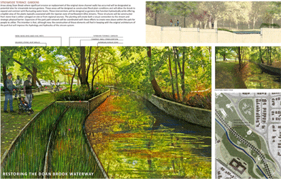
StreamsideTerrace Gardens
Areas along Doan Brook where significant erosion or replacement of the original stone channel walls has occurred will be designated as potential sites for streamside terrace gardens. These areas will be designed as constructed flood plain conditions and will allow the brook to expand and contract with fluctuating water levels. These interventions will be designed as gardens that function hydraulically while offering a legible view of the plants typically associated with the riparian zone of northeastern Ohio streams. These structures will be constructed from stone that is either salvaged on site or from regional sources. The planting will create both a visual connection to the stream and strategic physical barrier. Expansion of the park path network will be coordinated with these efforts to create new places within the park for people to utilize. The intention is that, although new, the construction of these elements will feel in keeping with the original architecture of the park but will improve the hydrology and hydraulics of the stream system.
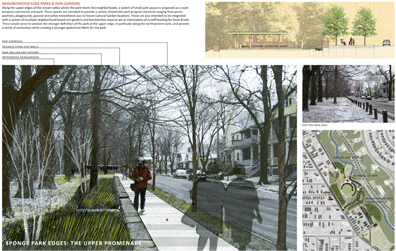
Neighborhood Edge Parks & Rain Gardens
Along the upper edges of the stream valley where the park meets the neighborhoods, a system of small park spaces is proposed as a seam between community and park. These spaces are intended to provide a variety of potential park program elements ranging from picnic pavilions, playgrounds, passive and active recreational uses to future Cultural Garden locations. These are also intended to be integrated with a system of localized neighborhood based rain gardens and bioretention areas to act as interceptors of runoff heading for Doan Brook. These would serve to catalyze the stronger definition of the park at the upper edge, in particular along the northwestern zone, and provide a sense of connection while creating a stronger pedestrian fabric for the park.
Infrastructure Garden Gateways
A series of garden and park spaces aimed at engaging the management of stormwater and the restoration of Doan Brook are proposed throughout the park. These elements vary in scale and form and are intended to optimize their programmatic relationships to the immediately adjacent neighborhoods. Certain areas are transformed as landform elements through the use of removed earthen material that will be generated by restoring Doan Brook. Other areas are developed in a spirit and form compatible with the Cultural Gardens as stormwater infiltration zones between upstream neighborhoods and the brook. In some cases these strategies are combined to form larger gathering spaces that can handle the temporary detention of either storm or flood water to help mitigate downstream flooding and reduce the instance of combined sanitary and storm system overflow. Several areas employ either detention or daylighting of culverted sections of Doan Brook. Other areas of the Park are defined by their relationship to human infrastructure, most notably transit and regional circulation networks. Major nodes are seen as important gateways into and through the park and are marked by a consistent design vocabulary utilized throughout the park.
Circulatory systems: the Braided and Sculptural Path and
the Riparian Forest
Interconnecting all areas of the park is a system of pathways, sidewalks and roadways that varies in surface and dimension in response to use expectations and relationship to the watershed. This circulatory system is conceptually reminiscent of the braided course of a healthy stream. The land that this system traverses becomes a ground for landform sculpting and use of variable surfaces that both improve functionality and provide memorable experiences of the park. Hard surfaces such as concrete are proposed for primary walkways, while alternative materials ranging from stabilized stone dust to resin based soil binders might be considered for secondary paths. Porous paving is proposed for roadway edges and are intended to be coordinated with a curbside stormwater garden system to reduce runoff velocity, promote infiltration and to filter water before it enters the stream. Drawing from regional examples of important earthworks such as the Great Serpent Mound, these new earth forms can create an exciting yet fitting new form within the park, provide low cost play areas and seating and create elements that draw people from the community to reintroduce themselves to the park. The entirety of these systems will be housed in a restored Native Riparian Forest defined by native plant communities and associations.
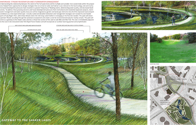
Watershed: Stream Restoration and Stormwater Management
Understanding the relationship between the extent of the full watershed and the multiple and variable micro-watersheds within the project area helped frame approaches to design strategies that are aimed at water and habitat issues relevant to the local ecology and community.
Increased development pressures have resulted in a greater frequency of flooding events, deteriorating water quality, and decreased biodiversity. To address these growing concerns and future development pressures from institutional and residential expansion projects, stormwater management and water quality measures will be integrated as garden and landscape elements into all of the improved road and park conditions as a new experiential layer. Civically scaled and detailed restoration and management strategies will include this stormwater park at Rudy Rogers Park, where Doan Brook enters the mile long culvert before re-emerging at the Fine Arts Garden. This park will detain upstream floods cascading through the sandstone escarpment and create a zone for environmental study for nearby schools. This park will serve as a gateway to the Shaker Lakes and be a critical new section of the Lake to Lake Bike and Hike Trail. This site is immediately adjacent to the soon to be renovated Cedar Hills Rapid Transit Station and will incorporate an outdoor learning pavilion and amphitheater.
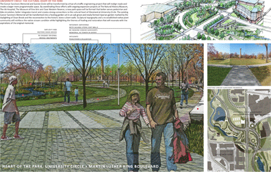
University Circle: The Cultural Heart of the Park
The Cancer Survivors Memorial and Suicide Circle will be transformed by virtue of a traffic engineering project that will realign roads and create a larger more programmable space. By coordinating these efforts with ongoing expansion projects at The Natural History Museum, The VA Hospital, The Museum of Fine Arts and Case Western Reserve, a new park space will be formed that better serves pedestrian and bike circulation, better integrates transit and creates strong connections to the cultural heart of Cleveland at University Circle. The existing Cancer Survivors Memorial will be transformed into a healing garden set in an oak grove and newly formed riparian garden marked by the daylighting of Doan Brook and the reconnection to the historic stone culvert walls. Sculptural topography and a re-established native plant community will reinforce the native stream condition while highlighting the themes of healing and restoration that will resonate with the aspirations of the original memorial.
Martin Luther King Boulevard and the Bridges of Rockefeller Park
The iconic image of Rockefeller Park is, undoubtedly, the series of rusticated stone bridges spanning the Doan Brook Valley and forming gateways from south to north between University Circle and Lake Erie. These grand structures are in a significant state of disrepair and warrant restoration. These bridges represent an important identifying condition of the park and functionally provide crucial connections between the East and West neighborhoods flanking the park. In this plan it is proposed to renovate these structures and more effectively use them as important landmarked points of entry into the park by providing pull-off parking zones along MLK Boulevard. These zones would serve as a traffic calming measure and as opportunities for redefining the nature of the roadway with planted medians, porous paving and site walls from the native sandstone. New lighting and electrical utilities will be coordinated to restore the original view shed condition of the park at these nodes. At least one new bridge is proposed to create a pedestrian connection between the Fine Arts Garden, Case Western Reserve and University Circle on the eastside to The Upper Chester neighborhood’s new Eco-village and Case Western’s West Quad Project on the westside.
Process and Production
The planning and design process was highly interdisciplinary and interactive. The project team stretched across a wide spectrum of design professionals including landscape architects, architects, planners, traffic engineers, and developers, and was complemented by a committed cadre of community and cultural representatives. Working from the client's core mission of community-based advocacy to 'promote and facilitate creative programs and convene civic partners around projects which enhance the economic strength and quality of life of the Cleveland community', a neighborhood liaison and facilitator was appointed to forge the critical link between the strategic planning and design process and the local community. A two-pronged approach of community engagement and facilitation was developed, where the client led larger-scale neighborhood meetings to communicate design and planning ideas and solicit public input, and the liaison, a former resident of the local community, literally walked door-to-door, engaging local residents in conversation about their hopes and desires for the park and their observations and opinions of the proposed design strategies.
The products of the strategic master plan were heavily weighted toward experiential perspective and sectional views in order for the community stakeholders to easily understand the intentions and implications of the design strategies. These were presented to the client and the community as discreet, small-scale neighborhood-based projects that can be implemented incrementally, over time, leveraging the coordination, energy and funding of private development, ongoing expansion of local cultural institutions and civic infrastructure projects. The incremental quality of these interventions is the key to the actual/real/real-world/true implementation of the master plan, and the distinguishing feature between it and the long history of shelved planning efforts that came before it. For this awards submittal, we are including only a small fraction of the imagery developed for the overall plan which included numerous nodes and moments along the length of the park which were developed to a similar extent, as well as plant, material and furnishing palettes to further flesh out the design.
Project Resources
Design Team
Lead Designers:
Siteworks
Pete OShea ASLA FAAR, principal
Din Botsford LEED AP
Galin Boyd, Associate ASLA
Jenny Cox ASLA
Alissa Diamond
John Meaney ASLA
Jordan Phemister ASLA
Anne Russell ASLA
Community Liaison and Facilitator
Austin Allen
Co-Designers
McKnight and Associates:
Jim McKnight, ASLA
Rob Morgan, ASLA
Jayme Schwartzberg, Associate ASLA
Traffic Engineers
HNTB

Park Master Plan (Image courtesy of Siteworks)

Park Layers Diagram (Image courtesy of Siteworks)

Martin Luther King Boulevard and the Bridges of Rockefeller Park (Image courtesy of Siteworks)

Circulatory Systems: The Braided and Sculptural Path and the Riparian Forest (Image courtesy of Siteworks)

Watershed: Stream Restoration and Stormwater Management (Image courtesy of Siteworks)
"This shows people how to dream on a larger scale. Very poetic and appropriate. Beautifully presented."
— 2009 Professional Awards Jury

University Circle: The Cultural Heart of the Park (Image courtesy of Siteworks)

Neighborhood Edge Parks & Rain Gardens ( Image courtesy of Siteworks)

Infrastructure Garden Gateways (Image courtesy of Siteworks)

Streamside Terrace Gardens (Image courtesy of Siteworks)