

«previous pageANAYSIS & PLANNING CATEGORY
Honor Award
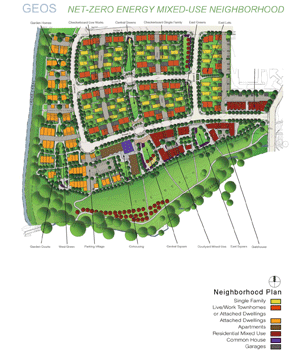
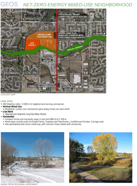
Geos Net Zero Energy Neighborhood, Arvada, CO
David Kahn Studio,
Eldorado Springs, CO
Michael Tavel Architects, Denver, Colorado
client: Norbert Klebl
Project Statement
Geos will be the largest net-zero energy, urban mixed-use neighborhood in the United States. Earth and sun power will completely sustain the community’s energy needs, and replace all fossil fuels. The neighborhood is intertwined with natural systems, stormwater fed landscapes, and civic places. Rain and snow melt feed street tree rain gardens, percolation parks, plazas, and community gardens. Geos received final development approval from the City of Arvada and will begin construction in Summer, 2009.
Project Narrative
Introduction
The Geos Neighborhood incorporates symbiotic relationships in site planning and architecture, at all scales. Urban density is optimized with passive solar access. Stormwater is integrated and omnipresent within the neighborhood layout. Energy is generated from ground source heat networks and photovoltaics on every rooftop. The architecture utilizes high performance building envelopes and super efficient mechanical systems. The overall town plan aims to foster bio-civic relationships with natural processes, neighborhood ecology, and environmental stewardship.
Project Data
Total Acreage:
25.2 acres
Number of Residential Units:
282
Net Density:
23.2 Dwelling Units/Acre
Commercial Square Footage:
12,000 sf — neighborhood service oriented
Civic Buildings:
CoHousing Community House on Central Square
Parks & Open Space:
8.5 acres – 34% of site includes:
Percolation Parks with fruit tree co-ops, gardens, play areas.
Town Squares with civic amenities, play grounds, event spaces. Mixed Use Meadow with native habitat, active & passive use areas, and agriculture.
Energy Systems:
1.3 Megawatt PV System; 5,000,000 BTU Geothermal System CARBON FREE — NO FOSSIL FUELS
Process:
2004–2007 Development Plan and Sustainable Mixed Use Design Code Completed.
2007 Planning Commission and City Council Approval
2008 Planning Staff Approval of Construction Documents
2009–2010 Phase 1 Construction.
2010–2012 Phase 2 and 3 Construction.
LEED Status:
Qualifies for LEED-ND (Neighborhood Design) at Silver Level.
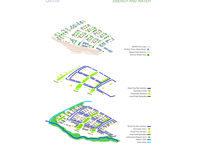
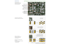
Net – Zero Energy Site Planning
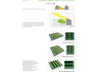
Net – Zero refers to energy production equal to the amount consumed. The key to creating a dense net-zero energy neighborhood in Colorado’s climate is to maximize passive solar access to all buildings and dwellings. This begins with the layout of streets, alleys, blocks, and parcels, followed by buildings and trees.
During the planning process many different street-block-parcel-building layouts were analyzed comparatively for their ability to both harvest and conserve energy. Each layout was evaluated using 3-D modeling of seasonal sun and shade patterns to discern the most efficient patterns. Energy modeling (with assistance from the National Renewable Energy Lab in Golden, Colorado) of each building and landscape design provided data on unit loads and production.
Key Strategies:
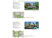
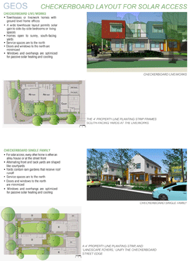
- Macro Layout – Parcels and buildings are stretched east-west for maximum solar access within an urban street grid with north-south alleys and greens.
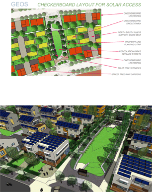
- Checkerboard Layout – Buildings are spaced and staggered for solar access.
- Geothermal Loop Fields integrated within open space and utility networks.
- Photovoltaics on every rooftop; Solar Thermal supplements Geothermal.
- Deciduous tree species, heights, and placement selected to assure both solar access to photovoltaics, and passive microclimate cooling.
- High performance passive solar buildings with air tight envelopes and heat recovery ventilation systems. Apertures to north are minimized, east and west apertures are controlled and shaded.
Civic Stormwater Planning
Stormwater is both precious and dangerous in Colorado’s arid climate. Conventional Colorado developments typically detain flash flood and monsoon runoff in large unusable detention basins, fenced off from the public realm. The key to integrating stormwater with public experience is to mimic predevelopment conditions by distributing runoff throughout the site. Decentralized detention allows for the design of a tributary system of site specific, multiple use environments.
During the design process many models of stormwater management were analyzed for the ability to detain the 100 year flood on site, and slowly release it in 24 hours. With assistance from the Denver Regional Urban Drainage & Flood Control District, and the Jefferson County Stormwater Quality Coordinator, each layout was evaluated for its capability to combine both stormwater and civic functions. The morphology of water quality, detention volumes, and reduced time of concentration would form the armature for the community’s pedestrian, park, and plaza network.
Key Strategies:
- Conceive of stormwater management holistically and at all scales.
- Permeable paving for water infiltration is used for all pedestrian ways and plazas.
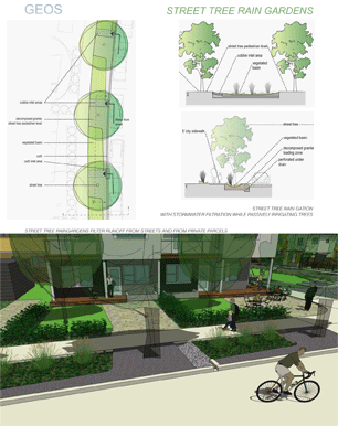
- Street Tree Rain Gardens receive, detain, and filter surface runoff from streets, alleys, and the surrounding environment, while irrigating streetscape plantings. They minimize directly connected impervious areas, reduce time of runoff concentration, while utilizing infiltration, evaporation, and evapotranspiration.
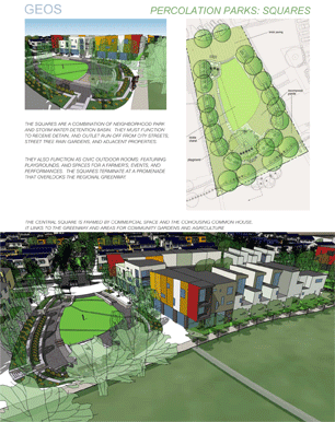
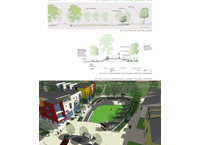
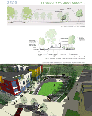
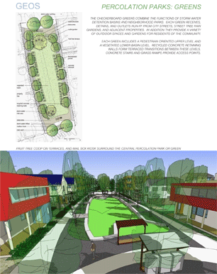
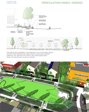
- Percolation Parks are stormwater detention basins designed as mixed-use parks and plazas. By mimicking predevelopment stormwater dispersal patterns they reduce the size and extent of the storm sewer system. Percolation Parks feature neighborhood amenities, urban agriculture, and wildlife habitat. They are placed prominently in the neighborhood and provide ease of access, human scale, and a diversity of uses.
- Localized Rain Gardens are integrated on every parcel through out the neighborhood, from mixed-use courtyards to residential yards. They receive runoff from paving and rooftops, providing an intimate experience of stormwater management.
- Level Outlet Spreaders slowly release outflows to the floodway, mimicking predevelopment sheet flow, and eliminating the need for riprap erosion control.
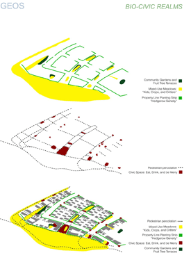
Planning for Urban Stewardship: Empowering Residents to
“Be the Resource”
The aims of Net-Zero Energy and Civic Stormwater serve a larger goal - to foster stewardship in the neighborhood, and enable residents to take active roles in managing their resources and environment. This can fold into participation in the social life and governance of the community.
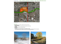
Planning for Goes involves many socially oriented features. A dense layout of varied housing options provides for diversity and affordability. A prolific pedestrian network of pathways, parks, and civic spaces is anchored by mail box kiosks, play areas, and gathering spaces for all occasions, large and small. All paths lead to the Ralston Creek Regional Greenway that connects to schools, recreation centers, and urban centers.
Processes of nature and agriculture are interwoven with civic and community life. Common greens are surrounded by fruit tree terraces, to be maintained and harvested by the adjacent homeowners. Community gardens and composting areas are dispersed throughout the site. All private yards receive great sunlight and are semi-enclosed like courtyards. Gutters and downspouts form tributaries to raingardens in each resident’s landscape.
Key Strategies:
- Integrate natural systems and processes within the fabric of everyday life. Mix stormwater management, food production, and biotic habitat with public pathways, parks, and civic spaces. Create complex mutually beneficial networks of unique ecosystems, each adapted for specific conditions.
- Give residents opportunities to play active roles in managing their resources, and caring for their environments.
- Provide agricultural opportunities through out the neighborhood, and at a diversity of scales; from pocket community gardens and orchards in each sub area, to larger Community Supported Agriculture.
- Fruit Tree Terraces, Property Line Planting Strips, and Landscape Foyers unite the pedestrian realm while enfranchising residents to personalize their environment.
- An Energy Systems Guide and Xeriscape Plant and Landscape Maintenance Manuals provide residents with detailed information on indoor and outdoor stewardship.
- Working with the local municipality and surrounding neighborhoods to identify and provide eco-amenities that serve the larger community.
Project Resources
City of Arvada Project Planner
Ben Thurston
City of Arvada Landscape Architect
Harry Johnson
Civil Engineer
Travis Nicholson, MB Consulting
City of
Arvada Engineering Dept.
Georgia Simpson
Jefferson Co. Stormwater Quality Coordinator
Michelle Delaria
Denver Regional Urban Drainage and Flood Control District
National Renewable Energy Lab, Golden, CO
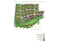
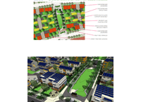
Neighborhood Plan (Photo: Geos Neighborhood)
Net-Zero Energy Mixed-Use Neighborhood (Photo: Geos Neighborhood)
Energy and Water (Photo: Geos Neighborhood)
Bio-Civic Realms (Photo: Geos Neighborhood)
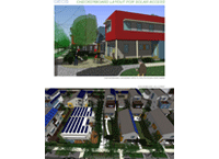
Optimize Density with Solar Access (Photo: Geos Neighborhood)
Optimize Density with Solar Access (Photo: Geos Neighborhood)
Checkerboard Layout for Solar Access (Photo: Geos Neighborhood)
Checkerboard Layout for Solar Access (Photo: Geos Neighborhood)
Checkerboard Layout for Solar Access (Photo: Geos Neighborhood)
"The first project that looks at solar in such a strong way and works with water collection. Great collaboration between the landscape architect and other designers. A model for planning and public presentation."
— 2009 Professional Awards Jury
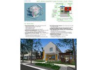
Net-Zero Energy and Fossil Fuel Free (Photo: Geos Neighborhood)
Stormwater Management and Civic Life (Photo: Geos Neighborhood)
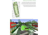
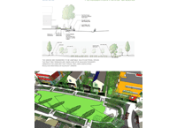
Street Tree Rain Gardens (Photo: Geos Neighborhood)
Percolation Parks: Squares (Photo: Geos Neighborhood)
Percolation Parks: Squares (Photo: Geos Neighborhood)
Percolation Parks: Greens (Photo: Geos Neighborhood)
Percolation Parks: Greens (Photo: Geos Neighborhood)